Tag Archives: Favorite Fotos

Ferrell’s Favorite Foto #20

Today’s foto has not been a favorite very long. Just this afternoon at the close of a wonderful day along the Dead Sea and the Jordan River. The story below.

Ewe and lamp grazing on the side of a cliff on Highway 1. Photo: ferrelljenkins.blog.

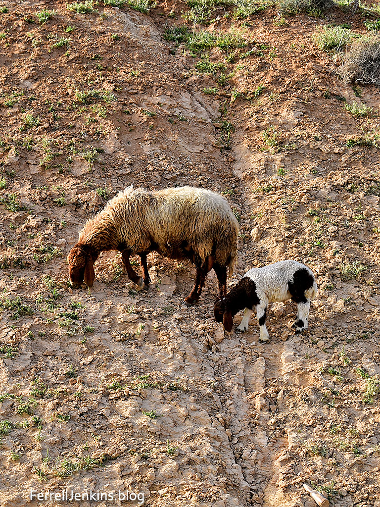
Ewe and lamb grazing along the side of Route 1 from the Dead Sea to Jerusalem and Tel Aviv. This area is just a few miles east of Jerusalem. Photo by Ferrell Jenkins.

I have been traveling privately on what I call a personal study tour. I have invited numerous people to join me from time to time. They are always knowledgeable, having traveled at least a few times before. This year I invited Luke Chandler to join me. Luke made his first trip to Israel on one of my tours. He is now an accomplished leader, and he has brought people to participate in excavations at various sites. We are neighbors. We both have a genuine interest in Israel as it pertains to the Bible. Luke left for home last Friday and I plan to leave Wednesday.

Now here is the story behind today’s photograph.

I spent much of the day traveling and stopping for fotos along the Dead Sea today. I visited the ancient synagogue at En Gedi, and then went to Kasser Al-Yahud, the traditional place where John baptized Jesus (Matthew 3). If we were  in Jordan, and we were only yards away, we would call it Bethany Beyond the Jordan (John 1:28).

On my way back to Jerusalem I noticed sheep along the STEEP hillside on the north side of Highway 1 that runs from the Dead Sea to Jerusalem and Tel Aviv. I was surprised to see a wide lane along the highway for cars with problems to park. There were long periods between groups of cars. I pulled over and made this photo from the car. Then I got out and made more of the flock.

So this foto is a favorite because of the subject and because of the unusual situation. Yes, the side of the road is close to a 90 degree angle.

I thought about parents and children. The lamb seems to have no fear of being on the hillside. The lesson we can learn is that children often learn fear or calmness from what they see in their parents.

Ferrell’s Favorite Fotos #19

Riblah served as a base of operation for the Egyptian Pharaoh Necho and the Babylonian King Nebuchadnezzar. The city is located on a broad plain about 50 miles south of Hamath (modern Hama in Syria), on the main road between Egypt and Mesopotamia. The Orontes River flows past the site on the west side. On a modern map you will locate Riblah in Syria immediately north of the border with Lebanon.

There is little more than a “country store” at the village today, but the name Riblah is preserved as Ribleh, Syria.

  • Pharaoh Necho imprisoned Jehoahaz, king of Judah, at Riblah. He later took him to Egypt where he died. The date was about 609 B.C. (2 Kings 23:31-34).
  • Zedekiah, puppet king of Judah, tried to escape capture by the Babylonians. He fled Jerusalem but was captured on the plains of Jericho and brought to Riblah. There Nebuchadnezzar passed sentence on him. His sons were slaughtered in his sight and he was bound with brass fetters and taken to Babylon. The date was 586 B.C. (2 Kings 25:5-7; see also Jeremiah 39:5-6; 52:9-10).
  • The officials of Zedekiah were taken to Riblah where they were put to death (2 Kings 25:19-21; see also Jeremiah 52:26-27).

In 2002 David McClister, a colleague at Florida College, and I spent several days visiting sites in Syria. Riblah was the most difficult to locate. Most folks, after seeing the site, would probably say, “What’s the big deal?”  Even though Riblah is mentioned only these few times in the Old Testament, it’s location makes it important in all movement between the south (Egypt and Israel) and Mesopotamia.

The ancient mount of Riblah, once headquarters of Babyonian king Nebuchadnezzar. FerrellJenkins.blog.

The ancient mount of Riblah, once headquarters of Babyonian king Nebuchadnezzar. Slide scan. Photo by Ferrell Jenkins in 2002.

This post is a repeat, but I thought the favorite photo needed more explanation than most of the images I am using.

Ferrell’s Favorite Fotos # 13

This view of Jerusalem is a favorite of many pilgrims and travelers. It is made from Mount Olivet with a view to the west across the Kidron Valley (John 18:1). It shows the full length of the eastern wall of the Old City. The area where you see the gold Dome of the Rock, now a Muslim shrine, is where the temples of Solomon and Herod once stood from about 966 B.C. to A.D. 70.

A view of Jerusalem from Mount Olivet. Photo: FerrellJenkins.blog.

A view of Jerusalem from Mount Olivet. Photo by Ferrell Jenkins.

The Israeli city of Jerusalem is partially visible beyond the Old City. One thing that makes this morning photo beautiful is that the sun is shining from the east on the Old City. In the background the heavy clouds float in from the Mediterranean  to bring the early and later rains at the appropriate season (Deuteronomy 11:14; James 5:7). Click on the photo for a larger image suitable for use in teaching.

Ferrell’s Favorite Fotos # 11

We have had the opportunity to see numerous fishermen demonstrate casting a net in the Sea of Galilee, but this was the best. Looking at this photo it is easy to recall Jesus’ selection of Peter and Andrew to become “fishers of men.”

Fisherman casting net on the Sea of Galilee. FerrellJenkins.blog.

This fisherman on one of the tourist boats is demonstrating casting a net near the warm waters near the Church of the Primacy on Galilee’s northern shore. Photo by Ferrell Jenkins.

 Passing alongside the Sea of Galilee, [Jesus] saw Simon and Andrew the brother of Simon casting a net into the sea, for they were fishermen. And Jesus said to them, “Follow me, and I will make you become fishers of men.” And immediately they left their nets and followed him. (Mark 1:16-18 ESV)

For more information about fishing and fishermen on the Sea of Galilee see these links: the ports; the fish; Tabgha (Heptapegon); and fishing the Sea of Galilee.

Ferrell’s Favorite Fotos # 8

Traveling in the Wadi Farah (or Faria) in 1982 with the late Jimmy Cravens of Tampa, Florida, we came upon a shepherd moving his sheep from one side of the road to the other. This scene calls to mind Psalm 23.

The LORD is my shepherd; I shall not want. He makes me lie down in green pastures. He leads me beside still waters. (23:1-2 ESV)

Sheep beside still water in Wadi Farah. FerrellJenkins.blog.

Sheep in green pastures, beside still water, in Wadi Farah. Scanned from slide made by Ferrell Jenkins in March, 1982.

This scene is located in a region often called the West Bank, part of the Palestinian Authority. The Wadi Farah leads from near Tirzah to the Jordan Valley.

Biblical characters such as Abraham and Jacob likely used this route to travel from the Jordan Valley to Shechem.

Ferrell’s Favorite Fotos #4

Of the places David McClister and I tried to locate in Syria in 2002, this was the most difficult.

The Syrian village of Ribleh. Site of the ancient town of Riblah where Nebuchadnezzar set up his headquarters, and where he killed the sons of Jechoniah in his presence, put out his eyes, bound him, and took him to Babylon. FerrellJenkins.blog.

The Syrian village of Ribleh. Site of the ancient town of Riblah where Nebuchadnezzar set up his headquarters, and where he killed the sons of Zedekiah in his presence, put out his eyes, bound him, and took him to Babylon. Scanned slide photo by Ferrell Jenkins.

See the Index of articles about Babylon, including a few references to Riblah, here.

Zedekiah, puppet king of Judah, tried to escape capture by the Babylonians. He fled Jerusalem but was captured on the plains of Jericho and brought to Riblah. There Nebuchadnezzar passed sentence on him. His sons were slaughtered in his sight and he was bound with brass fetters and taken to Babylon. The date was 586 B.C. (2 Kings 25:5-7; see also Jeremiah 39:5-6; 52:9-10).

Ferrell’s Favorite Fotos #3

It was quite a thrill when I first found and walked on this nice stretch of Roman Road near the Turkish village of Saglikli about 12 miles north of Tarsus of Cilicia. Tarsus served as one of the great crossroads of history. It was the home of Saul of Tarsus, later known as the Apostle Paul who described it as “no insignificant city” (Acts 21:39; 9:11; 22:3).

Roman road north of Tarsus in Cilicia. ferrelljenkins.blog.

Roman Road near the Turkish village of Saglikli, about 12 miles north of Tarsus in Cilicia. Home of Saul of Tarsus. Photo by Ferrell Jenkins.

This road that was constructed about A.D. 200 during the reign of the Emperor Septimius Severus. Did Paul and Silas follow this same route on an earlier road during the second journey?