Category Archives: Photography

Solomon’s Quarries discovered by American Medical Doctor J. T. Barclay

Dr. James Turner Barclay was sent to Jerusalem by the American Christian Missionary Society in 1851 as a medical and evangelistic missionary. During his first trip he stayed until 1854 and  returned for a second stint from 1858 to 1861. Barclay was active in medical work, treating more than 2,000 cases of malaria during his first year in the city.

Grave stone of James T. Barclay, and his wife Julia, in the Campbell Cemetery at Bethany, WVA. Photo by Ferrell Jenkins.

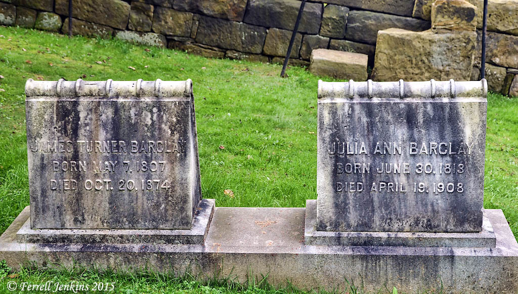
Grave stone of Dr. James T. Barclay, and his wife Julia, in the Campbell Cemetery at Bethany, West Virginia. Photo by Ferrell Jenkins.

Barclay wrote a book in 1858 about the city of Jerusalem under the title The City of the Great King; or, Jerusalem As It Was, As It Is, and As It Is To Be. In it he tells about some of his explorations in and around the Old City. In a section dealing with nether Jerusalem he discusses the discovery of what is commonly called Solomon’s Quarry. Dr. J. T. Barclay inserts an article written by Dr. R. G. Barclay, his oldest son, about the exploration and their conviction that this was the quarry from which stone for the temple was taken.

This, without doubt, is the very magazine from which much of the Temple rock was hewn—the pit from which was taken the material for the silent growth of the Temple (The City of the Great King; Or, Jerusalem as It Was, as It Is, and as It Is to Be. pp. 462-463).

One of my graduate professors, Dr. Jack P. Lewis, wrote a series of articles about nineteenth century explorers of the Bible Lands in the Biblical Archaeologist (and perhaps some other journals). His article about Dr. Barclay was published in 1988 (Vol. 51). The biographical portraits have been collected in Early Explorers of Bible Lands, published by Abilene Christian University Press in 2013.

Entrance to Solomon's Quarries on Sultan Suleiman St. about a block east of Damascus Gate. Photo by Ferrell Jenkins.

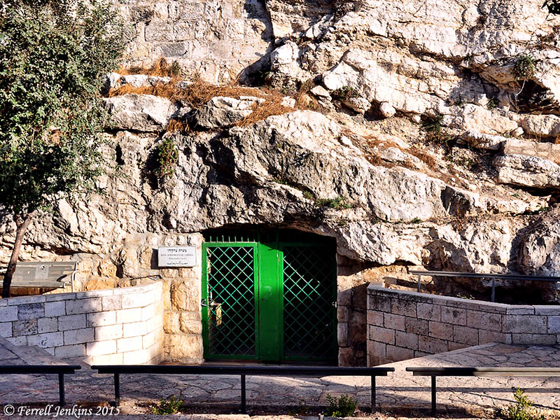
Entrance to Solomon’s Quarries on Sultan Suleiman Street about a block east of Damascus Gate. The sign to the left of the door identifies the place as King Solomon’s Quarries (Zedekiah’s Cave). Photo by Ferrell Jenkins.

Lewis provides a brief summary of Barclay’s discovery of Solomon’s Quarries (also called Zedekiah’s Cave).

Barclay claimed credit for discovering the cavern under the north wall of the city near the Damascus Gate. Popularly known as Solomon’s Quarries, this area is called Zedekiah’s Grotto by Israelis in honor of the last king of Judah. According to legend, Zedekiah is said to have fled Jerusalem through this cavern upon the Babylonian conquest of the city in 587 BCE J. J. Simons, who has identified the area as the Royal Caverns mentioned by Josephus (The Jewish War, book 5, chapter 4, paragraph 2; see Thackeray 1961: 245) estimated that 350,000 cubic meters of stone were quarried there (Simons 1952: 13).

When Barclay heard rumors of a cavern under the north wall, he tried to locate an entrance to it. He and his two sons conducted their search at night in order to avoid detection by Moslems, who would have opposed such an expedition.

The group made their way into the blocked cavern through a hole started by the Barclay dog when it was digging for bones. Once inside the cave they discovered Hebrew and Arabic inscriptions that were too effaced to be deciphered (Barclay 1858: 461–62; Johnson 1858: 98–100). They also found crosses carved into the walls, indicating the presence of Christian pilgrims from an earlier period.

The Barclays were disappointed that they found no outlet to the Haram or the Antonia fortress but they were impressed by the vast piles of blocks and chippings over which they had to clamber and were convinced they had discovered the quarries from which the stones for Solomon’s Temple were cut.

In a future post we will include some photos of the interior of the Quarries.

For more about Dr. James Turner Barclay and his work, see TheRestorationMovement website here.

Another look at Hippos (Sussita)

I think many Bible Land travelers pass En Gev on the eastern shore of the Sea of Galilee and never realize that the site of Hippos is visible about one and a half miles to the east. Perhaps that is because of the almost magnetic attraction of the Sea of Galilee.

View of Hippos/Sussita (Susita) with the Sea of Galilee. Photo by Ferrell Jenkins.

View of Hippos/Sussita (Susita) with the Sea of Galilee. Photo by Ferrell Jenkins.

Vassilios Tzaferis wrote about Hippos in Biblical Archaeology Review:

If you look at the site of Sussita/Hippos from an adjacent mountain, or, better yet, from the air, and follow the adjoining ridge, or saddle, to the east, the site looks like the head of a horse and the saddle, or ridge, looks like the long, outstretched neck of a horse. It is this configuration that gave the site its name for nearly a thousand years. The ancient Greeks, who apparently were the first to settle the site, must have been aware of this resemblance because they named the place Hippos (horse). When the Jews conquered the city, they translated the name to Sussita, “mare” in Aramaic. When the Arabs conquered it, they called it Qal’at el Husn, the “fortress of the horse.”

The summit of the mountain is a plateau of about 37 acres on which lie scattered the ruins of what was once a beautiful town overlooking the lake.

Our story begins—perhaps it will begin much earlier after the site is thoroughly excavated—about a century after Alexander the Great conquered and Hellenized much of the then-known world. After Alexander’s death in 331 B.C., his empire split in two—the Ptolemies in Egypt and the Seleucids in Syria shared this world. Over the centuries Palestine passed from one side to the other, occasionally winning its own independence. The first evidence we now have of organized habitation at Hippos indicates that it was founded by the Seleucids in the middle of the third century B.C., very probably as a frontier fortress against the threat of the Ptolemaic kingdom to the south. The settlement was located on a most strategic point, on the western approach to Gaulanitis (today’s Golan Heights). The site’s natural fortification and defense allowed it to serve equally as a fortress stronghold and as an effective frontier post, controlling any movement to the east, both in time of war and peace. In about 200 B.C., the boundaries of the Seleucid kingdom were pushed down to southern Palestine, so Hippos lost much of its strategic significance but it retained its importance as an urban cultural center, with a social and political organization in accord with the principles of a Greek polis.

When the town was formally recognized as an official constitutional polis, it was renamed Antiocha, in honor of the head of the Seleucid kingdom, Antiochus the Great (III), although the old name Hippos was also officially used.

Hippos had a port on the Sea of Galilee “to serve the commercial and navigational needs” of the city.

The progress of the city as a Hellenistic center was interrupted for a period of about 20 years during the first half of the first century B.C. Sometime between 83 and 80 B.C., the Judean king Alexander Jannaeus, who then ruled an independent fiefdom, conquered Hippos. According to the first-century A.D. historian Flavius Josephus (Antiquities of the Jews 14.75), Jannaeus forced Hippos’ heathen inhabitants to be circumcised and to accept Judaism. In 64 B.C., however, the Roman army entered the scene. The Roman general Pompey took the city from the Jews; it was then included in the League of the Ten Cities, the Decapolis, created by Pompey in the northern Jordan Valley and adjacent Transjordan. Each city in the Decapolis had jurisdiction over an extensive area. As a member of the Decapolis, Hippos enjoyed internal autonomy and could even mint its own coins. The population of Hippos welcomed Pompey with open arms.

About 35 years later, Hippos again became part of a Jewish realm. In 30 B.C. the Roman emperor Augustus gave Hippos to Herod the Great, who ruled it until his death 26 years later, in 4 B.C. After Herod’s death, Hippos was assigned by the Romans to the province of Syria.

During the First Jewish Revolt against Rome (66–70 A.D.), the Jews attacked Hippos and its Greek inhabitants, who retaliated by killing or imprisoning the Jews residing there. (Biblical Archaeology Review 16:05, Sep/Oct 1990).

Riesner says that Hippos “must be” the city of the Decapolis presupposed in Mark 5:1-20 (the account of casting demons into swine; Dictionary of Jesus and the Gospels 40). It might be. Hippos is the closest of the cities of the Decapolis to the area of Jesus’ ministry which was centered in Capernaum. It would make sense that Gentiles in this area might be growing pigs.

And he [the healed demon-possessed man]went away and began to proclaim in the Decapolis how much Jesus had done for him, and everyone marveled. (Mark 5:20 ESV)

And great crowds followed him [Jesus] from Galilee and the Decapolis, and from Jerusalem and Judea, and from beyond the Jordan. (Matthew 4:25 ESV)

Could Hippos Be the City Set on a Hill? Chris McKinney wrote an article for Seeking a Homeland in May, 2010 suggesting consideration of Hippos (Hippus) for the “city set on a hill” mentioned by Jesus in Matthew 5:14b). He uses Google Earth to show the location of various sites around the Sea of Galilee. There is also a nice photo allowing you to see how the site looks like the head of a horse. Read his article here. Certainly plausible.

Parts of this post are reposted from March 26, 2010. See here.

Pan mask uncovered at Decapolis city of Hippos-Sussita

Earlier today a press release was issued by The University of Haifa regarding a recent discovery at Hippos-Sussita, a town of the Decapolis located about 2 km. east of the Sea of Galilee. (For those who have been in the area, the mound is visible to the east of En Gev.)

A large bronze mask of the god Pan, the only of its kind, was uncovered at the University of Haifa’s excavation at Hippos-Sussita National Park. According to Dr. Michael Eisenberg, bronze masks of this size are extremely rare and usually do not depict Pan or any of the other Greek or Roman mythological images. “Most of the known bronze masks from the Hellenistic and Roman periods are miniature”.

Dr. Michael Eisenberg, University of Haifa, holding the Pan mask discovered at Hippos-Sussita.

Dr. Michael Eisenberg, University of Haifa, holding the Pan mask discovered at Hippos-Sussita.

It seems that in recent years, the mysteries of Hippos-Sussita have been revealing their secrets in an extraordinary way: first, a sculpture of Hercules was exposed by the winter rains of 2011, then, two years later, a basalt tombstone with a sculpture of the deceased’s bust was uncovered. Now there is a new surprise: the only finding of a bronze mask of unnatural size, in the form of the god Pan/Faunus.

Excavations at Hippos-Sussita are usually conducted in the summer. However, a series of intriguing structures on the ridge of the city, where the ancient road passed, led to a one-day dig in the winter. The dig focused on a basalt structure which the researchers assumed was a type of armoured hangar for the city’s projectile machines. The finding of a ballista ball made of limestone, a different material from the basalt that was customarily used at Hippos-Sussita to make balista balls, made them realize that it was an enemy’s projectile.

In light of this interesting find the researchers decided to search the structure for coins to help them date the the balls. It didn’t take long for the metal detector, operated by the capable hands of Dr. Alexander Iermolin, head of the conservation laboratory at the Institute of Archaeology at the University, to start beeping frantically. The archaeologists were not yet aware of what was in store for them: “After a few minutes we pulled out a big brown lump and realized it was a mask. We cleaned it, and started to make out the details: The first hints that helped us recognize it were the small horns on top of its head, slightly hidden by a forelock,” said Dr. Eisenberg.

Dr. Alexander Iermolin immediately after uncovering the Pan mask at Hippos-Sussita.

Dr. Alexander Iermolin immediately after uncovering the Pan mask at Hippos-Sussita.

Horns like the ones on the mask are usually associated with Pan, the half-man half-goat god of the shepherds, music and pleasure. A more thorough cleaning in the lab, revealed  strands of a goat beard, long pointed ears, and other characteristics that led Dr. Eisenberg to identify the mask as depicting a Pan/Faunus/Satyr. “The first thought that crossed my mind was, ‘Why here, beyond the city limits?’ After all, the mask is so heavy it could not have just rolled away. The mask was found nearby the remains of a basalt structure with thick walls and very solid masonry work, which suggested a large structure from the Roman period. A Pan altar on the main road to the city, beyond its limits, is quite likely. After all, Pan was worshiped not only in the city temples but also in caves and in nature. The ancient city of Paneas, north of Hippos-Sussita, had one of the most famous worshiping compounds to the god Pan inside a cave. Because they included drinking, sacrificing and ecstatic worship that sometimes included nudity and sex, rituals for rustic gods were often held outside of the city”, Dr. Eisenberg explained.

Archaeological team member cradles the mask of Pan.

Archaeological team member cradles the mask of Pan.

Now the archeologists have begun to uncover the basalt structure, in the hopes of finding more clues to its purpose. They assume that it was used for defensive purposes “Perhaps in a later period, during the Pax Romana, when the city fortifications were not required, the building turned into a place of worship to the god of shepherds, and maybe what we have here is a magnificent fountain-head or burial offerings of a nearby mausoleum,” Dr. Eisenberg suggests.

As mentioned, the researchers are unfamiliar with any similar bronze mask from the Roman or Hellenistic era of Pan or a Satyr. “Most of the masks are usually similar in size to theater masks, are made of stone or terracotta and are of ritual, apotropaic, decorative or symbolic significance. I contacted the curators of some of the world’s greatest museums, and even they said that they were not familiar with the type of bronze mask that we found at Hippos. Hippos-Sussita cannot compete in wealth with the ancient cultural centers of the Roman Empire and as such, a finding of this kind here, of all places, is amazing,” concluded Dr. Eisenberg.

The press release may be read in its entirety here.

Jesus visited the region of Decapolis during His public ministry (Mark 5:20; 7:31; Matthew 4:25).

We commonly think of Pan in association with the site of Panias (Banias=Caesrea Philippi), an area visited by Jesus (Matthew 16:13-20). See more info about the site here.

HT: Joseph I. Lauer

Thinking better of Mary Magdalene

A group of Christian women recently convened at the ancient site of Magdala on the western shore of the Sea of Galilee “to honor International Women’s Day and discuss women’s empowerment.”

Advocates spoke of the issue of legal prostitution in Israel and the struggles of the over 15,000 Israeli women who are drawn into the industry, often against their will. (The Jerusalem Post Newsletter, March 11, 2015).

The meeting at Magdala seemed to discuss some important issues, but the characterization of Mary Magdalene is inaccurate to say the least.

Each speaker related the issues of feminism and women empowerment to the lessons of Mary Magdalene, speaking about how the healing process for women who have suffered such abuse. Consecrated woman, Jennifer Ristine, spoke of how Mary Magdalene inspires hope and healing for victims of abuse.

“Through the transforming experience of love, Mary Magdalene’s dignity was affirmed and she becomes a leader among leaders, inspiring hope and  reconciliation,” Ristine said. “Do we have anything in common with this woman? When a woman is deeply convinced of the truth that she is unconditionally loved, she is set free to be what she is called to be for others. She becomes a catalyst for reconciliation.”

An entire “cult” has risen around Mary Magdalene over the years to the point that some have suggested that Mary Magdalene was the wife of Jesus, and that she “carried the royal bloodline of Jesus Christ” (The DaVinci Code, p. 244, 249).

Some writers assume that Mary Magdalene is to be identified with the sinful woman of Luke 7:36-50. The comments by William Hendriksen are helpful in correcting this misunderstanding.

First among the women here mentioned is Mary called Magdalene; that is, Mary of Magdala (meaning The Tower) located on the western shore of the Sea of Galilee and south of Capernaum. She figures very prominently in all the four Passion accounts. She was one of the women who later: (a) watched the crucifixion (Matt. 27:55, 56; Mark 15:40; John 19:25); (b) saw where Christ’s body was laid (Matt. 27:61; Mark 15:47; Luke 23:55); and (c) very early Sunday morning started out from their homes in order to anoint the body of the Lord (Matt. 28:1; Mark 16:1; Luke 24:10). Besides, she was going to be the first person to whom the Risen Christ would appear (John 20:1–18; see also Mark’s disputed ending, 16:9).

The item about the seven demons that had been expelled from Mary Magdalene has led to the wholly unjustifiable conclusion that she was at one time a very bad woman, a terribly immoral person. But there is not even an inkling of proof for the supposition that demon-possession and immorality go hand in hand. Weird and pitiable mental and/or physical behavior are, indeed, often associated with demon-possession (Luke 4:33, 34; 8:27–29; 9:37–43, and parallels), not immorality. (Hendriksen, Baker New Testament Commentary: Luke, comments on Luke 8:2-3)

Our aerial photo was made in 2011. The area of ancient Magdala is seen on the left 40% of the photo along the shore of the Sea of Galilee. On the right side you will see the Plain of Genessaret. Mount Arbel and the Via Maris are seen in the background. The mountains of Upper Galilee are visible in the distance. Click on the photo for an image suitable for use in presentations.

Aerial view of Magdala and the Plain of Genessaret. Photo by Ferrell Jenkins.

Aerial view of Magdala and the Plain of Genessaret. Photo by Ferrell Jenkins.

It is wonderful that any variety of sin can be forgiven, but let’s not turn Mary Magdalene into something she was not. The words of Paul, the apostle of Christ Jesus, are encouraging.

Or do you not know that the unrighteous will not inherit the kingdom of God? Do not be deceived: neither the sexually immoral, nor idolaters, nor adulterers, nor men who practice homosexuality, nor thieves, nor the greedy, nor drunkards, nor revilers, nor swindlers will inherit the kingdom of God. And such were some of you. But you were washed, you were sanctified, you were justified in the name of the Lord Jesus Christ and by the Spirit of our God. (1 Cor. 6:9-11 ESV)

Coins, silver and bronze objects from time of Alexander found in northern Galilee

The following report comes from the Israel Antiquities Authority. Rather than indent it, I am leaving it full width for ease of reading.

Thanks to alert spelunkers exploring a cave in the north of the country:

 A Cache of Rare Coins and Silver and Bronze Objects from 2,300 Years Ago was Exposed

According to Amir Ganor, director of the IAA Unit for the Prevention of Antiquities Robbery, “the reporting of the treasure by honest citizens will contribute to our understanding of the history of the Land of Israel”

A month after the discovery of the gold treasure by divers off the coast of Caesarea, another report has reached the Israel Antiquities Authority of a find involving a cache of rare coins and silver and bronze objects 2,300 years old, in a cave in northern Israel. Officials in the Israel Antiquities Authority believe this is one of the important discoveries to come to light in the north of the country in recent years, and will require much time to study in order to crack the secrets of the cave.

Two weeks ago Reuven Zakai, his son Hen Zakai and their friend Lior Halony, members of the Israeli Caving Club, set out to make preliminary preparations for a visit by the club in one of the largest and well-hidden stalactite caves in the north.

The three lowered themselves down in the ground, into the stalactite cave, and wriggled through a narrow passage in front of the cave. They wandered and crawled between the different parts of the cave for several hours.

The youngest member of the group, Hen, 21 years old, says he forced his way into one of the narrow niches when he suddenly caught sight of a shining object. There he discovered two ancient silver coins which it later turned out had been minted during the reign of Alexander the Great who conquered the Land of Israel at the beginning of the Hellenistic period (late fourth century BCE). Several pieces of silver jewelry were found alongside the coins, among them rings, bracelets and earrings, which were apparently concealed in the cave, together inside a cloth pouch some 2,300 years ago.

A coin of Alexander of Macedon that was part of the silver cache. Photographic credit: Shmuel Magal, courtesy of the Israel Antiquities Authority.

A coin of Alexander of Macedon that was part of the silver cache. Photographic credit: Shmuel Magal, courtesy of the Israel Antiquities Authority.

In the opinion of archaeologists at the Israel Antiquities Authority, “The valuables might have been hidden in the cave by local residents who fled there during the period of governmental unrest stemming from the death of Alexander, a time when the Wars of the Diadochi broke out in Israel between Alexander’s heirs following his death. Presumably the cache was hidden in the hope of better days, but today we know that whoever buried the treasure never returned to collect it”.

The spelunkers realized they found an important archaeological discovery and reported it to inspectors of the Unit for the Prevention of Antiquities Robbery in the Israel Antiquities Authority. This weekend officials of the Israel Antiquities Authority entered the cave together with members of the Israeli Caving Club. The IAA inspectors were excited to discover evidence of human habitation that occurred in the cave over extended periods.

A general picture of the cache of silver objects: two coins of Alexander of Macedon, three rings, four bracelets, two decorated earrings, three other earrings (probably made of silver) and a small stone weight. Photographic credit: Clara Amit, courtesy of the Israel Antiquities Authority.

A general picture of the cache of silver objects: two coins of Alexander of Macedon, three rings, four bracelets, two decorated earrings, three other earrings (probably made of silver) and a small stone weight. Photographic credit: Clara Amit, courtesy of the Israel Antiquities Authority.

At this point they believe they have found artifacts in the cave that first date to the Chalcolithic period c. 6,000 years ago; from the Early Bronze Age c. 5,000 years ago, the Biblical period 3,000 years ago and the Hellenistic period approximately 2,300 years ago. Numerous pottery vessels were also discovered in the cave. In some regions of the cave ancient pottery vessels were found on which stalagmites had developed. Some of the pottery vessels had bonded with the limestone sediments and cannot be separated. The Israel Antiquities Authority reports that the combination of a stalactite cave and archaeological finds is both fascinating and rare. The finds in the cave will allow the researchers – archaeologists and geologists alike – to accurately date both the archaeological finds and the process of stalactite development.

Amir Ganor, director of the Unit for the Prevention of Antiquities Robbery in the Israel Antiquities Authority wants to commend the three members of the caving club, “They understood the importance of the archaeological discovery and exhibited exemplary civic behavior by immediately bringing these impressive archaeological finds to the attention of the IAA. After the gold treasure from Caesarea, this is the second time in the past month that citizens have reported significant archeological finds and we welcome this important trend. Thanks to these citizens’ awareness, researchers at the Israel Antiquities Authority will be able to expand the existing archaeological knowledge about the development of society and culture in the Land of Israel in antiquity “.

The Israel Antiquities Authority wishes to emphasize that the Law of Antiquities states that all antiquities belong to the state, and that failure to report or removing antiquities from their location, or selling or trading them is an offense punishable by up to five years imprisonment. Officials in the Israel Antiquities Authority want the location of the cave to remain secret because of the many hazards inside it. Apart from the concern that the archaeological strata and stalactites might be damaged, there is a real danger to visitors to the cave because there are hidden and extremely deep underground cavities in it through which one might fall. In addition, the Israel Antiquities Authority wishes to stress that crawling in caves is dangerous and requires appropriate training and safety equipment.

You may locate a copy of this release, along with some other photos, here. More photos have been published in the Daily Mail here.

I have seen articles about this in several Israeli papers yesterday and today. Thanks to Joseph I. Lauer for the IAA press release.

Assyrian Nimrud (Calah) destroyed

The phrase “Assyrian Triangle” came to be used of three famous Assyrian cities of northern Mesopotamia: Nimrud, Khorsabad, and Nineveh. I think an understanding of this helps when we study Jonah 3:3.

Then the word of the LORD came to Jonah the second time, saying, 2 “Arise, go to Nineveh, that great city, and call out against it the message that I tell you.” 3 So Jonah arose and went to Nineveh, according to the word of the LORD. Now Nineveh was an exceedingly great city, three days’ journey in breadth. (Jonah 3:1-3 ESV)

Parrot says that the word Nineveh might have been understood by those living far away from Assyria by what we now call “‘the Assyrian triangle’ which stretches from Khorsabad in the north to Nimrud in the south, and with an almost unbroken string of settlements, covers a distance of some twenty six miles” (Nineveh and the Old Testament, 85-86).

As Alexander explains, this is,

“the region between the rivers Tigris, Zabu and Ghazir, extending from Dur-Sharrukin (Khorsabad) in the north to Calah (Nimrud) in the south” (Tyndale Old Testament Commentaries, Vol.26).

A few days back we learned of the wanton destruction of gates at Nineveh and various artifacts from the museum in Mosul. Friday we learned from various news outlets that Nimrud was bulldozed.

Nimrud is identified with the Calah of Genesis 10:11-12. When I made a short visit to the region in 1970, we stopped at Tell Nimrud for only a few photos. Here is one that has held up fairly well.

A Lamassu at one of the entries to Assyrian Nimrud. Photo by Ferrell Jenkins, 1970.

A Lamassu at one of the entries to Assyrian Nimrud. Photo by Ferrell Jenkins, 1970.

For examples of these winged bulls in better condition we must visit the British Museum or one of the other museums where a few good examples may be found.

The other photo I am sharing is of the ruins of the ancient ziggurat at Nimrud. Our guide, George, is seen talking with a man I recall as being a keeper at the site. Ziggurats are common in Iraq, but because many of them were were made of mud brick they often resemble a pile of dirt from a distance.

Ruins of the ziggurat at Nimrud. Photo by Ferrell Jenkins, 1970.

Ruins of the ziggurat at Nimrud. Photo by Ferrell Jenkins, 1970.

Christopher Jones continues his good updates on the Gates of Nineveh here. The Assyrian International News Agency (AINA) has a helpful report here.

If you like to follow this sort of thing, the National Geographic report is here. A friend on FB sent the TIME report here.

Eleanor Robson, Professor of Ancient Near Eastern History at the University College London, recommends Nimrud: Materialities of Assyrian Knowledge Production.

Tel ‘Eton is thought to be biblical Eglon

Tel ‘Eton (also Tel Eiton and Tel Aitun) is not the easiest archaeological site to locate. The site is situated on Israel’s border with the Palestinian West Bank. Palestine is on the east side of the mound and a military firing range is on the west side. When Leon Mauldin and I located the place we decided it would be best to stick to the gravel road without straying too far to the left or the right — sort of like Joshua.

“Be very firm, then, to keep and do all that is written in the book of the law of Moses, so that you may not turn aside from it to the right hand or to the left,  so that you will not associate with these nations, these which remain among you, or mention the name of their gods, or make anyone swear by them, or serve them, or bow down to them.  (Joshus 23:6-7 NAU)

Tel ‘Eton currently is equated with biblical Eglon by many scholars. Recent excavations have been conducted under the direction of Prof. Avi Faust of Bar Ilan University.

Here is a photo of the tel from the south and perhaps a little to the east.

Tel 'Eton (Tel Eiton; Tel Aitun) from the south (and east). Photo by

Tel ‘Eton (Tel Eiton; Tel Aitun) from the south (and east). Photo by Ferrell Jenkins.

Eglon is mentioned at least eight times in the Bible, all in the book of Joshua (10:3, 5, 23, 34, 36, 37; 12:12). The Scripture emphasizes that Israel defeated the king of Eglon. Notice the relationship between Lachish and Eglon.

And Joshua and all Israel with him passed on from Lachish to Eglon, and they camped by it and fought against it.  They captured it on that day and struck it with the edge of the sword; and he utterly destroyed that day every person who was in it, according to all that he had done to Lachish.  Then Joshua and all Israel with him went up from Eglon to Hebron, and they fought against it.  (Joshua 10:34-36 NAU)

The distance from Lachish to Eglon (on a straight line) is 7 miles. From Eglon to Hebron is 10½ miles.

A recent article in Popular Archaeology reports,

An archaeological team has uncovered remains of what may have been an administrative center during the period when Judahite kings ruled out of ancient Jerusalem.

Led by project director Avraham Faust, an archaeologist with Bar-Ilan University near Tel Aviv, Israel, excavations at the site of Tel ‘Eton located on the edge of the fertile Shephelah and the Hebron hill country to its east have revealed structures, artifacts, and fortifications that tell of an ancient city that historically straddled the eastern edge of the lowlands between the biblical kingdom of Judah and Jerusalem in the east and the cities of the Philistines on the Mediterranean coastal plains of the west.

Among the finds was a large, 240 sq.m. 8th century BCE house structure built following a four-room plan typical of ancient Israelite dwellings, featuring high-quality construction and, with its location at the highest point on the mound, commanding a strategic view of all areas below. The ancient building, along with its town context, was strategically located at the cross-roads of important north-south and east-west routes, set above fertile agricultural country.

“The structure was excavated, almost in its entirety, and was composed of a large courtyard with rooms on three sides,” stated Faust. “The building was nicely executed, including ashlar stones in the corners and openings. Hundreds of artifacts were unearthed within the debris, including a wide range of pottery vessels, loom weights, many metal objects, botanical remains, as well as many arrowheads, evidence of the battle which accompanied the conquest of the site by the Assyrians.”

The article also reports,

But the most abundant finds for the early periods were dated to the Late Bronze Age (ca. 1550-1200/1150 BCE).

That is the period of Joshua.

Here is a portion of the excavation from 2011.

Tel Eton excavation in 2011. Photo by Ferrell Jenkins.

Tel Eton excavation in 2011. Photo by Ferrell Jenkins.

The Tel ‘Eton Excavations website contains many small photos, plans, history, bibliography, etc.

HT: Joseph Lauer

Parrot: It is necessary to see in order to understand

When I began to learn of and appreciate the work of André Parrot, Curator-in-Chief of the French National Museums, Professor at the School of the Louvre, and Director of the Mari Archaeological Expedition, I purchased most of those masterful little books he wrote about Biblical cities. In connection with the recent post about Nineveh I took down my well-marked copy of Nineveh and the Old Testament (1955) and began to read again.

André Parrot writes of his April 1950 arrival at Mosul.

During the twenty years spent in Iraq or in Syria, we had never had an opportunity to cross the ‘Assyrian triangle’ Once again we realized how necessary it is to see in order to understand, and especially to hold in the memory. Knowledge gained from books is certainly not enough, for names which are not attached to any reality are nothing more than ghosts. Ghosts of cities, shadows of men, vague floating shapes, without solidity, though one tries to capture it with the aid of a drawing, a photograph or a vivid description. All students of archaeology know this by experience: nothing can replace actual contact with the object. That is why museums are so important; because there one can recognize the long chain of human history stretching out continuously from its beginning, but in which, instinctively we have a special interest in detecting and observing the first links. But the object is a prisoner in its glass case. Tom from its natural surroundings it has lost its true speech. Nevertheless it exerts a pull, it beckons one to take the road. It is impossible to contemplate the Assyrian reliefs in the Louvre or the British Museum without calling up the image of Nineveh.

Parrot points out that a visit to Nineveh can be disappointing “if one expects to see murals or palaces.” These things, he says, have been destroyed or crumbled away.

No kingdom endures forever, as the prophet Daniel reminded us long ago. Parrot says that he had only four days to visit the Assyrian Triangle (Nineveh, Nimrud, Khorsabad, and Asshur). In the evenings during his visit, he stayed with the Dominican Fathers. He says his memory of Nineveh,

is bound up with that of Mosul and the white cell in the monastery where, every evening of that short stay, we were able to meditate only a few yards from the Assyrian capital, on the vanity of empires and the fate which awaits all of them.

For the same reasons I have spent many years encouraging Bible students to visit the Bible lands.

The British Museum displays many reliefs from Nineveh. Information posted with the relief below says that it dates to about 700-692 BC. It comes from the SW Palace, Rm. 14, panels 13-15. After the capture of Alammu, a town of uncertain location, the prisoners are brough before the Assyrian king. Some carry heads of the dead. The king, Sennacherib, was shown in his chariot, but this part is now lost (WA 124786-7). Click on the photo for a larger image.

This Assyrian relief from Nineveh shows Prisoners from the town of Alammu. British Museum. Photo by Ferrell Jenkins.

This Assyrian relief from Nineveh shows Prisoners from the town of Alammu. British Museum. Photo by Ferrell Jenkins.


The Fall of Nineveh (again)

The ancient site of Nineveh is located about 300 miles north of Baghdad. The mound is one mile east of modern Mosul near the bank of the Tigris River.

Nineveh, the most renowned capital of the Assyrian Empire, is most prominent in the Bible during what we call the Neo-Assyrian Period (900-612 B.C.). Well known kings include Ashurnasirpal (885-860 B.C.), Shalmaneser III (859-824 B.C.), Tiglath-pileser (745-727 B.C.), Shalmaneser V (727-722 B.C.), and Sargon II (722-705 B.C.), Sennacherib (705-681 B.C.), Esarhaddon (681-669 B.C.), and Ashurbanipal (669-c. 627 B.C.). [List and dates from the revised ISBE article by Donald J. Wiseman.]

Nineveh fell in 612 B.C., and the Assyrian Empire came to an end at the battle of Carchemish in 605 B.C.

The LORD called it “that great city” (Jonah 1:2), but little remains of the grandeur and the beauty of ancient Nineveh. My only opportunity to visit Nineveh was on May 14, 1970. I would like to have better photos, but I wanted to share a few slides that I made of the gates.

The first photo shows some reconstruction around the Addad Gate. Ancient ruins can be seen at the entry. This is the gate we have seen continuously on various news programs since the first week we learned of the Islamic State (also ISIS and ISIL) in the area. (I have replaced the colorless sky with blue. Or, is it gold?)

Addad Gate of ancient Nineveh. Photo by Ferrell Jenkins, 1970.

Addad Gate of ancient Nineveh. Photo by Ferrell Jenkins, 1970.

The next gate is known as the Nergal Gate. In 1970 there was one complete winged bull and one partially destroyed bull within the reconstructed gate.

Reconstructed Nergal Gate at Nineveh. Photo by Ferrell Jenkins, 1970.

Reconstructed Nergal Gate at Nineveh. Photo by Ferrell Jenkins, 1970.

The only other gate I was able to photograph is the Shamash Gate.

Reconstructed Shamash Gate at Nineveh in 1970. Photo by Ferrell Jenkins.

Reconstructed Shamash Gate at Nineveh in 1970. Photo by Ferrell Jenkins.

The traditional tomb of Jonah is at Nebi Yunus.

Ancient Nineveh. Map by Fredarch, Wikimedia Commons.

Ancient Nineveh. Map by Fredarch, Wikimedia Commons.

Jonah the prophet was sent to preach in Nineveh. See the book of Jonah and the comment Jesus made on this in Matthew 12:38-41. You will notice Nebi Yunus on the sketch map. This designated the tomb of the Prophet Jonah according to Islamic tradition. Incidentally, Jonah is popular in the Muslim religion and there are several monuments to him. He is said to be buried at Nebi Yunus and at Mashad (Gath-hepher) in Israel. Some reports indicate that this tomb has been destroyed by IS.

At another time we may discuss some of the significant biblical events associated with Nineveh.

Yesterday I watched the 5+ minute video of the destruction of artifacts in the Mosul Museum. Later last evening I thought I would watch it again, but discovered that it had been taken down by YouTube. Excerpts are currently available at the BBC, the Daily Mail, and likely other news outlets.

We can be thankful that great collections from the ancient Assyrian Empire can be seen at the British Museum and the Louvre, with smaller collections scattered in other museums. To this thought Todd Bolen added, “where they are safe, for now.” Another friend wrote by Email, “If they [ISIS thugs] are not stopped, this could be coming to a museum or library near you!!”

I just came across a blog called Gates of Nineveh written by Christopher Jones, a Ph.D student in ancient Near Eastern history at Columbia University. Some of our readers might find this site helpful.

Update. Christopher Jones assesses the damage at the Mosul Museum. He identifies many of the pieces recently destroyed in a current post here. I have added this blog to my list of blogs I follow on the Scholarly Page of the Biblical Studies Info Page.

Pilate erected a Tiberium in Caesarea Maritima

An inscription bearing the name of Pontius Pilate was found at Caesarea Maritima June 15, 1961 during the excavation of the Roman theater. The stone on which the inscription is found had been reused in the theater. The photo below shows a replica of the inscription displayed in the building described by Murphy-O’Connor as the Palace of the Procurators. The original inscription is in the Israel Museum.

Pilate inscription displayed in the Palace area at Caesarea Maritima. Photo by Ferrell Jenkins.

Pilate inscription displayed in the Palace area at Caesarea. Photo by Ferrell Jenkins.

It is the inscription that has bearing on our current study relating to the Imperial Cult in Roman Palestine. Murphy-O’Connor gives the following translation:

Pontius Pilate, Prefect of Judaea, made and dedicated the Tibereieum to the Divine Emperor. (The Holy Land, Fifth Ed., p. 243)

The top line has the word for Tiberium. The second line has [Pon]tius Pilatus, and the third line seems to be the title of Pilate. Only one letter remains on the fourth line.

Joan Taylor, whose 2006 New Testament Studies article we have mentioned before, reads the inscription as follows:

  1. [_ _ _] S TIBERIÉUM
  2. [_ _ PO]NTIUS PILATUS
  3. [PRAEF]ECTUS IUDA[EA]E
  4. [_ _ _ _ _] É[_ _ _ _ _ _ _]

She translates the inscription as,

  1. [. . .] Tiberieum
  2. [.Po]ntius Pilate
  3. [Pref]ect of Judaea
  4. [. . .] e [. . .]

If you use Logos, you will be able to locate a suggested reconstruction of Pontius Pilate’s Inscription in the Faithlife StudyBible Infographics.

Taylor’s interpretation of the inscription is significant.

The word ‘Tiberieum’ is found nowhere else in the corpus of Latin inscriptions or literature and, given the relatively small size of the inscription and its terse quality, this Tiberieum should probably be understood as something of modest proportions. Possibly this small structure was attached to the theatre of Caesarea, located in the southern part of the city, which would explain its existence as a step in the remodelled theatre later on. (566)

Taylor describes the Tiberieum.

A dedicated structure in honour of the emperor Tiberius, a res sacra, would easily be called in Latin a ‘Tiberieum’. The most natural thing in terms of the Latin word would be to consider this to be not some secular lighthouse for the help of sailors or any other profane building, but an edifice or annex associated with the Roman imperial cult. (567)

Taylor’s excellent article covers Pilates coins, the shields he erected in Jerusalem, and the tiberium he built at Caesarea. This allows her to conclude that Pilate “does seem to have been purposively determined to maintain, if not advance, the Roman imperial cult in Judaea.” (582)

Once more, for those who wish to follow up on this subject, here is the bibliographic reference to Taylor’s article.

Taylor, Joan E. “Pontius Pilate and the Imperial Cult in Roman Judaea.” New Testament Studies 52. 2006: 555-582.

Other helpful materials include:

Bond, Helen K. “The Coins of Pontius Pilate: Part of An Attempt to Provoke the People or to Integrate Them into the Empire? Journal for the Study of Judaism XXVII 3. 1996: 241-262.

Carl Rasmussen has written about this topic on his Holy Land Photos’ Blog here. In a post here, Rasmussen emphasizes that Herod’s Imperial Cult Temples were “all less than 40 miles from Nazareth/Capernaum,” and that the temples “had been in existence for over 40 years!”

We may add that Pilate’s activities were closer to the time of the ministry of Jesus and the beginning of the church.

Note to Those Who Heard My Florida College Presentation. While I was working on this series of articles I noticed that I had misspelled the name of the Roman Emperor Tiberius throughout the presentation. I used the spelling of the town Tiberias. I am sure that all of my former students will agree that there should be no counting off for misspelled words. 🙂

I am also aware of the different spelling of the structure credited to Pilate. Tiberieum is the more typical British-type spelling; Tiberium is often used by American writers.

Emperor Worship in Asia Minor. I have been asked if I will discuss Emperor Worship as it relates to the book of Revelation. At this time the answer is no. Perhaps later on. I always presented material on this when I taught Revelation, and I have included a chapter on the subject in Studies in the Book of Revelation which is available at the Florida College Bookstore.