Category Archives: Photography

Models can be valuable teaching aids

Model reconstructions can be helpful in teaching when the original is not available. Such is true of the temple of biblical times. Herod’s temple was a magnificent building, according to the disciples of Jesus.

And as he came out of the temple, one of his disciples said to him, “Look, Teacher, what wonderful stones and what wonderful buildings!” (Mark 13:1 ESV)

Jesus left the temple and was going away, when his disciples came to point out to him the buildings of the temple. (Matthew 24:1 ESV)

Using the hints from the New Testament, Josephus, and other Jewish sources, some scholars have made a model of the Second Temple (Herod’s Temple). For many years this model was located on the grounds of the Holyland Hotel, but recently has been moved to the grounds of the Israel Museum. Click for a larger image.
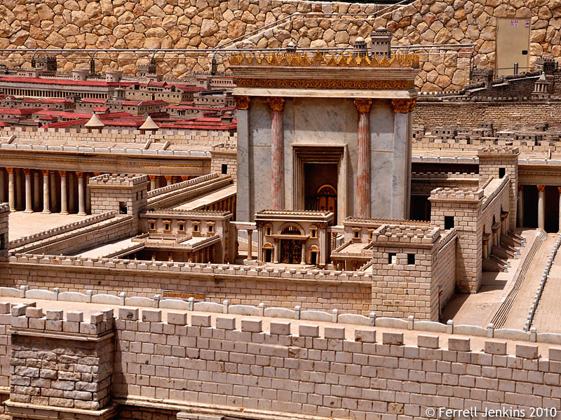
Second Temple Model at the Israel Museum. Photo by Ferrell Jenkins.

Second Temple Model at the Israel Museum. Photo by Ferrell Jenkins.

Watchtowers were used in vineyards (Isaiah 5:2; Luke 14:28; see here), and as lookout posts.

Then he who saw cried out: “Upon a watchtower I stand, O Lord, continually by day, and at my post I am stationed whole nights. (Isaiah 21:8 ESV)

The concept is used figuratively of the LORD’S care for His people.

for you have been my refuge, a strong tower against the enemy. (Psalm 61:3 ESV)

The name of the LORD is a strong tower; the righteous man runs into it and is safe. (Proverbs 18:10 ESV)

Yesterday afternoon we stopped by Yad Hashmona in the Judean Hills near Abu Ghosh (Kiriath-jearim) to visit the Biblical Village. Yad Hashmona operates a guest house and guiding center. Some readers will recognize it as the site of the campus of Master’s College IBEX program.

The Biblical Village provides a wonderful site for teaching, and photos of the reconstructions should be helpful too.
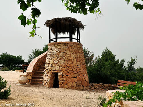
Watchtower, Biblical Garden, Yad Hashmona. Photo by Ferrell Jenkins.

Watchtower, Biblical Village, Yad Hashmona. Photo by Ferrell Jenkins.

Actually I wrote about this to provide Todd his regular fix of Israel while he is in exile in Texas. 🙂
Acco, Akko, Acre, Tell el Fukhar

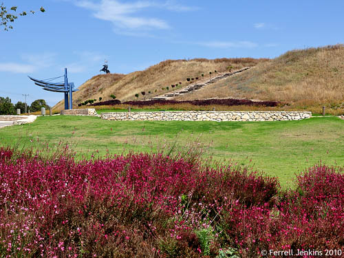
Saterday afternoon we drove from Tiberias to Akko. On my previous tour I failed to get any photos of the ancient tel of Acco (also spelled Akko and Acre). The mound is known as Tell el Fukhar (hill of clay pottery) in Arabic.

Excavations by Prof. Moshe Dothan between 1973-1985 demonstrated that the site was first inhabited in the Early Bronze Age (about 3000 B.C.).

Tel Akko (Acco, Acre). Photo by Ferrell Jenkins.

Tel Akko (Acco, Acre). Photo by Ferrell Jenkins.

Acco is mentioned only once in the Bible. The city is within the territory originally allotted to the tribe of Asher, but the tribe was unable to conquer it.

Asher did not drive out the inhabitants of Acco, or the inhabitants of Sidon or of Ahlab or of Achzib or of Helbah or of Aphik or of Rehob, (Judges 1:31 ESV)

After about 100 B.C. the coastal city was known as Ptolemais (Acts 21:7). Paul spent one day with the brethren here on the return from his third journey.

The Cove of the Sower

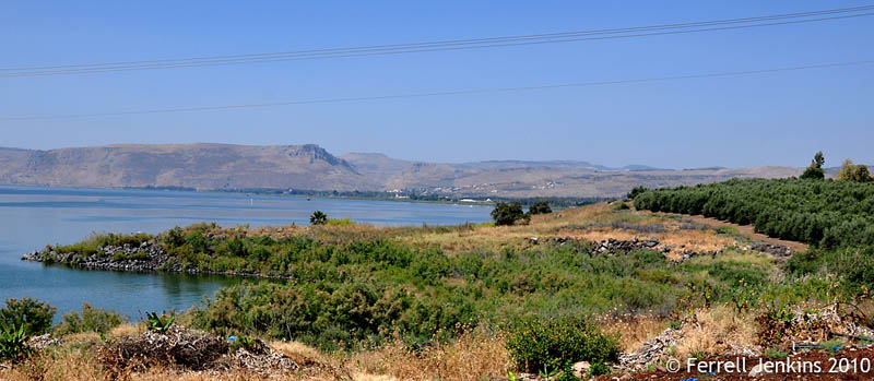
A few times before I have tried to get some good photos of the cove of the sower, and wrote about it in August, 2008. Saturday I put forth some extra effort to make a good photo at the spot on the north end of the Sea of Galilee called the Cove of the Sower. Some have suggested that this would have been the place where Jesus could speak to large numbers who assembled to hear Him.

Read the full account given by Mark in 4:1-20. Here is the way it begins:

He began to teach again by the sea. And such a very large crowd gathered to Him that He got into a boat in the sea and sat down; and the whole crowd was by the sea on the land.  And He was teaching them many things in parables, and was saying to them in His teaching,  “Listen to this! Behold, the sower went out to sow. (Mark 4:1-3)

Read the parallel accounts in Matthew 14:1-15 and Luke 8:4-10.

B. Cobbey Crisler conducted some experiments at places where the Bible records that large crowds gathered. The attempt was to see if the large number were able to hear a speaker without the aid of modern sound equipment. The places were Kadesh-barnea, Shiloh,  and The Cove of the Sower in Galilee. I suggest you read the entire article (“The Accoustics and Crowd Capacity of Natural Theaters in Palestine.” Biblical Archaeologist, 1976. Vol. 39. Num. 4.

The study indicated that the Cove of the Sower would allow between 5000 and 7000 people to hear.

Over the years different crops have been planted in the area, and this makes it difficult to compare older and more recent photos. The highway runs just above the level of the top of the olive trees. This photo is made looking west.

Cove of the Sower by Ferrell Jenkins

Cove of the Sower. Photo by Ferrell Jenkins

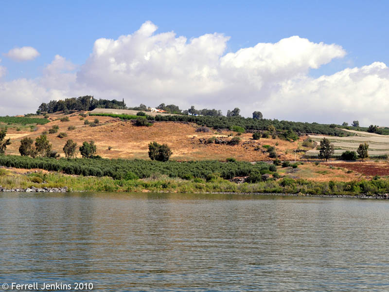
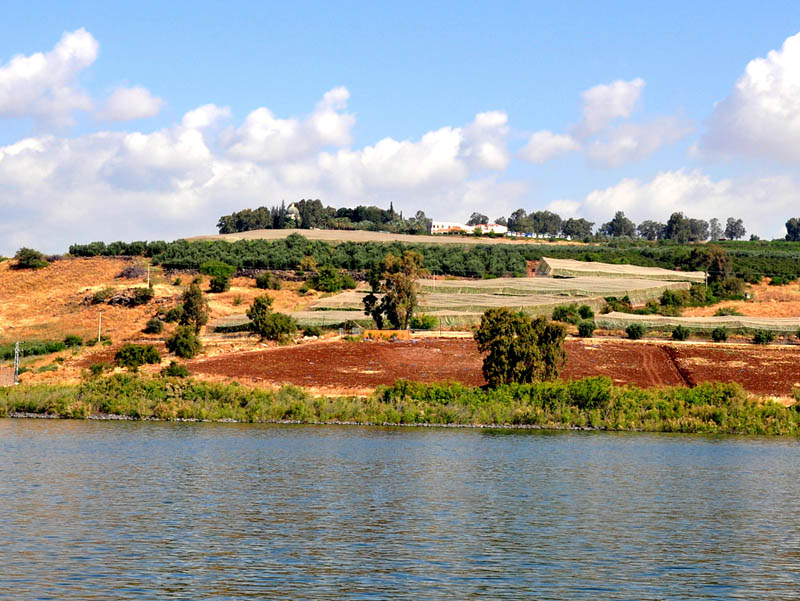
A couple of weeks ago I made the following photo from a boat a short distance south of the shore.

Cove of the Sower From the Sea of Galilee by Ferrell Jenkins.

Cove of the Sower From the Sea of Galilee. Photo by Ferrell Jenkins.

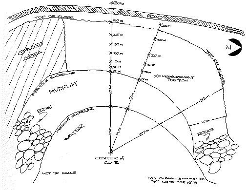
The following sketch from Crisler’s article in Biblical Archaeologist may help you to understand this better.

Cove of Sower sketch from Crisler's article in BA.

Cove of Sower sketch from Crisler's article in Biblical Archaeologist.

The terrain and the crops have changed since Crisler wrote.

Friday in lower Galilee

Today we drove from Tiberias past the Horns of Hattin, a site where the Crusaders thought Jesus spoke the beatitudes, through the Bet Netofa Valley to Sepphoris.

Sepphoris is an interesting site with a history dating from the Iron Age to modern times. The site has seen a considerable amount of archaeological excavation. Much of the work has been under the direction of my Temple Terrace neighbor, Dr. James Strange of the University of South Florida.

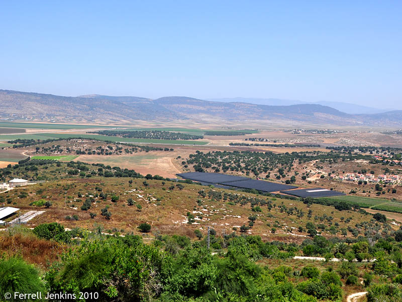
When I asked Elizabeth to select today’s photo, she picked the one I made of the Bet Netofa valley from atop the fortress at Sepphoris. This valley served as a main travel route from Nazareth, Sepphoris, Yodfat, and Cana to the cities around the Sea of Galilee. We think that Jesus must have used this route as he traveled from Nazareth to Capernaum.

And he went down to Capernaum, a city of Galilee.  (Luke 4:31a ESV)

Across the valley to the north is the location of Yodfat, the home of Josephus, and Khirbet Kanna, thought to be the site of Cana of Galilee (John 2). Click on the photo for a larger image.

View of the Bet Notofa Valley north of Zepphoris. Photo by Ferrell Jenkins.

View of the Bet Netofa Valley north of Zepphoris. Photo by Ferrell Jenkins.

We also visited Bethlehem of Galilee, a McDonald’s, and made some photos of Tel Megiddo before returning to our hotel on the shore of the Sea of Gailiee.

After dinner we sat for a while on the deck overlooking the sea. The Sea of Galilee is located in a rift nearly 700 feet below sea level. The heat can be oppressive during the day in this basin. In the evening a pleasant breeze flows in the area; it can even feel cool. I thought of the Biblical text that speaks of Jesus healing the sick and oppressed after sunset.

That evening at sundown they brought to him all who were sick or oppressed by demons. (Mark 1:32 ESV)

The Scriptures are amazing, aren’t they. The Book and the Land blend together to reveal a wonderful harmony and a magnificent Savior.

The acacia tree

Today we drove along the entire length of the Dead Sea on the western shore. Even places like the terrain of the wilderness of Judea and the Dead Sea have a beauty all their own.

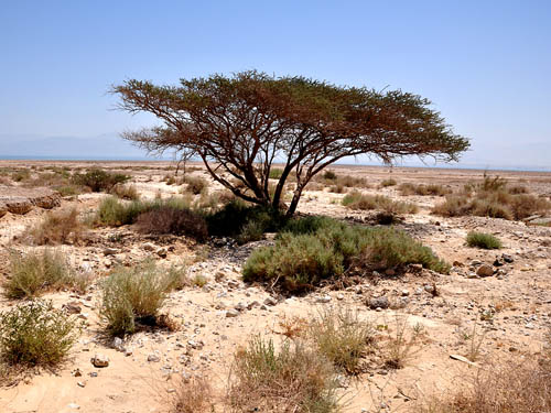
The acacia is one of the few trees seen along the shore of the Dead Sea and in the wilderness of Judea, and in the Sinai.

A lone acacia tree on the shore of the Dead Sea. Photo by Ferrell Jenkins.

A lone acacia tree on the shore of the Dead Sea. Photo by Ferrell Jenkins.

You doubtless recall that the tabernacle was constructed while Israel dwelt in the Sinai wilderness. Many of the pieces of furniture, including the ark of the covenant, were made of acacia wood.

Bezalel made the ark of acacia wood. Two cubits and a half was its length, a cubit and a half its breadth, and a cubit and a half its height. And he overlaid it with pure gold inside and outside, and made a molding of gold around it. (Exodus 37:1-2 ESV)

Tonight we are on the shore of the Sea of Galilee on the north side of Tiberias.

Our group heads for home

Our tour of Israel and Jordan came to an end this evening as the group went to the Ben Gurion International Airport for departure to the United States.

We visited a variety of sites today, but spent most of our time in the Shephelah (lowlands).  We are informed in 2 Chronicles about the activity of King Uzziah (792–740 B.C.) in the  Shephelah.

And he built towers in the wilderness and cut out many cisterns, for he had large herds, both in the Shephelah and in the plain, and he had farmers and vinedressers in the hills and in the fertile lands, for he loved the soil. (2 Chronicles 26:10 ESV)

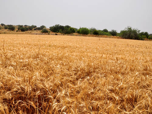
Wheat fields are in abundance in the Shephelah today.

A Wheat Field in the Shephelah. Photo by Ferrell Jenkins.

A Wheat Field in the Shephelah. Photo by Ferrell Jenkins.

Elizabeth and I said goodbye to our tour group and turned to Jerusalem. We plan to visit several more sites in Israel before returning home. By now the group should have begun their 13 hour flight home.

— ♦ —

Update: May 11. Last evening before going to bed I began tracking the flight of our friends returning home. When I checked it this morning I noticed that they have been routed north across Turkey, Eastern Europe, and north of Iceland. The flight continued across Greenland. Now they are headed south over Canada toward the Great Lakes area. The flight is delayed by 2 hours. This is because of the Iceland Volcano. A friend returning from Greece to the USA told me a similar story about his flight.

A beautiful backdrop for a photo

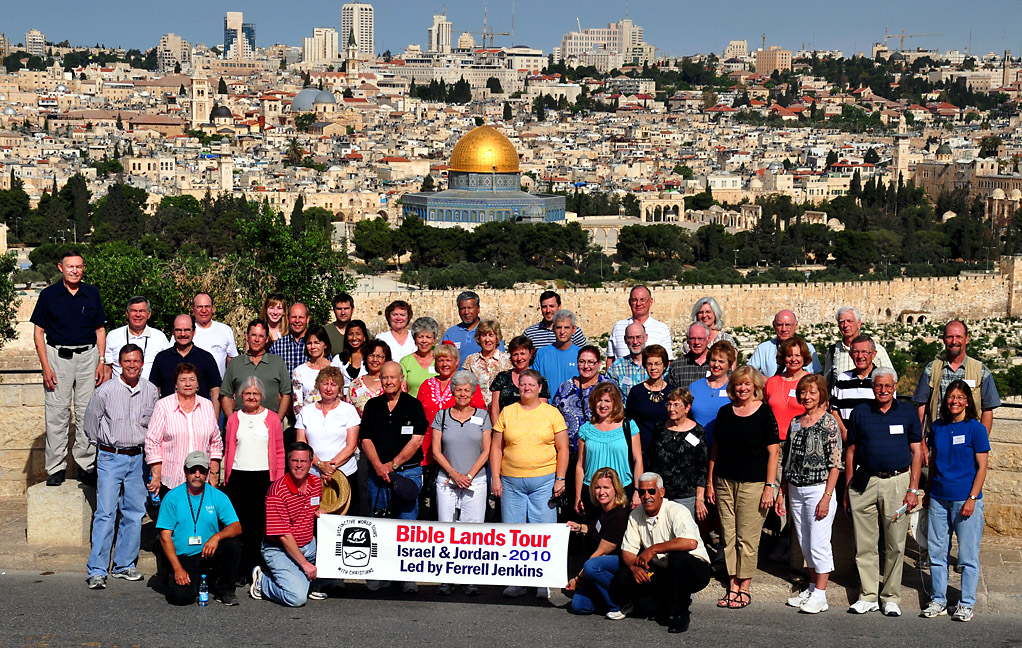
The city of Jerusalem provides a beautiful backdrop for a group photo. We almost always have a photo made of the group from the Mount of Olives with the city of Jerusalem in the background.

Bible Land Tour Group in Jerusalem - May 8, 2010.

Bible Land Tour Group in Jerusalem - May 8, 2010.

At this time of year there are no clouds to be seen, but the sky is clear. Click on the photo of our group of 46 travelers, plus our guide and driver, for a larger image. This will allow you to pick out any of the persons you may know. These folks are from numerous states ranging from the Northwest to Florida and Southern California to the Midwest.

We crossed out of Israel into the region controlled by the Palestinian Authority to visit Bethlehem. There we visited the Church of the Nativity and (one of) the Shepherd’s Fields. Tourists always enjoy shopping in Bethlehem. Specialties include olive wood carvings, mother of pearl, and jewelry. In the past I have enjoyed visiting a store operated by two brothers, but in the years of the Second Intifada they closed the store and moved to the USA where they had gained citizenship.

Today we visited a shop with some history — the Kando Store. One does not have to read very much about the early history of the Dead Sea Scrolls to encounter the name Kando. He was the shopkeeper who bought some of the original scrolls from the bedouin. In those years he operated a store directly across from the American Schools of Oriental Research (now the Albright Institute) in East Jerusalem (then in Jordan). I think it was 1969 (or 1970 or 1971) when Melvin Curry and I went to Kando’s antiquities shop and purchased about $1,000 worth of antiquities for Florida College. Those antiquities are now displayed in the Chatlos Library on the campus in Temple Terrace, FL.  They have been used in the Bible and Archaeology class many times. Today $1,000 would buy only about 4 good Herodian lamps, but we got a nice collection back then.

Kando was a Syrian Christian whose full name was Khalil Iskander Shahin. His name appears many times on the page describing the Dead Sea Scrolls in the Schøyen Collection. His family now operates the Kando Store in Bethlehem. All of the scrolls, and things pertaining to the scrolls, that came to the hands of Kando, have now been disposed of except for the original jar in which the Temple Scrolls was found.

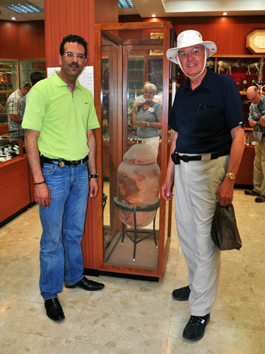
I was pleased to meet Shibly, the grandson of Kando, and have my photo made with him. You can see the original jar in the case between us.

Shibly, grandson of Kando, the Temple Scroll Jar, and Ferrell Jenkins.

Shibly, grandson of Kando, the Temple Scroll Jar, and Ferrell Jenkins.

It was 1956-57 when I began reading about the Dead Sea Scrolls. Being in the Kando Store today was an added excitement to any already great day of touring.

A full day in Jerusalem

Our visits today included the City of David excavations. What a tremendous work has been done here. After visiting the work done by Eilat Mazar, of what she thinks is the palace of David (many think this is an overstatement of the evidence), we visited the work done by Yigal Shiloh from 1978 to 1985, walked through the Canaanite water system, visited the Pool of Siloam, then left the area along steps leading up toward the Temple Mount. At some point along the way we were in the sewer of ancient Jerusalem until exiting on the street. We walked completely around the City of David.

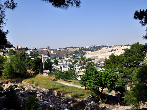
For a photo today I want to share a view of the Temple Mount area to the Mount of Olives. This photo was made from St. Peter in Gallicantu, the supposed house of Caiaphas and Annas.

View of theTemple Mount and Mount of Olives.

View of the Temple Mount and the Mount of Olives. Photo by Ferrell Jenkins.

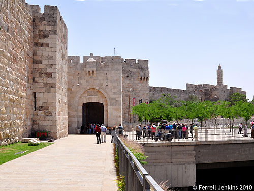
We also visited Jaffa Gate and saw the newly renovated gate.  Here is how it looks today. Nice, I think.

Jaffa Gate - Newly renovated 2010. Photo by Ferrell Jenkins.

Newly renovated Jaffa Gate, 2010. Photo by Ferrell Jenkins.

After visiting the Church of the Holy Sepulcher, the Pool of Bethesda, other sites along the way, and St. Peter in Gallicantu, we returned to the comfort of our hotel.

Back in Israel from Jordan

Yesterday we visited Petra and enjoyed the evening on the shores of the Dead Sea in Jordan. I did not have a good connection at the Dead Sea hotel, so I was unable to post anything.

This morning we crossed back into Israel. These crossings always take a bit of time. We left our hotel at 8 a.m. and arrived at the border before 9:00 a.m. It probably took an hour or more to complete the procedures.

We visited Masada, Qumran, and Jericho. I am sure that I will later want to tell you some things about Jericho, but it will have to wait. After I take care of some of the details of the tour with a group of 46 persons it doesn’t leave a lot of time or energy for blogging.

Everyone in our group is doing well. I don’t think there is anyone who is not enjoying this travel experience.

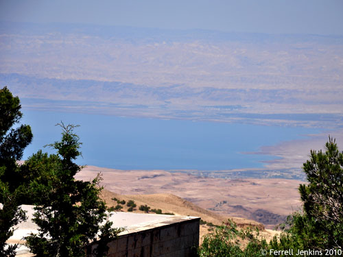
Tuesday we went to Mount Nebo. From there it is possible to see the northern end of the Dead Sea. I think the view was the clearest I have ever seen, and I have been there numerous times since 1967.

The Dead Sea as seen from Mount Nebo. Photo by Ferrell Jenkins.

The Dead Sea as seen from Mount Nebo. Photo by Ferrell Jenkins.

Mount Nebo is the place from which Moses viewed the land that the LORD had promised to Abraham’s seed (Deuteronomy 34:1-8).

Some of the other members of our group are posting interesting material. Scroll down to May 2 for a post containing the links.

A great day in Galilee

After breakfast our group walked to the dock in Tiberias and boarded a boat for a ride on the Sea of Galilee. At first it appeared that it might be a bit hazy on the sea. However, as we moved along the sky cleared and it turned out to be a wonderful day for photographs and teaching about the sites associated with the ministry of Jesus.

A few of the tour members have been to Israel before, but for most of them it is the first trip. It doesn’t matter how many times one comes here he/she always learns something new.

I had arranged earlier with our tour guide and tour company to have a demonstration of cast net fishing on the sea and to sail past the Cove of the Sower, the name given to the site where Jesus taught from a boat to people sitting on the shore.

Again he began to teach by the lake. Such a large crowd gathered around him that he got into a boat on the lake and sat there while the whole crowd was on the shore by the lake. (Mark 4:1 NET)

The view of the traditional Mount of Beatitudes (Matthew 6-7) was tremendous. The appearance of the hill has changed over the years. Trees have grown up around the church. A larger building, painted a light color, has made the site less aesthetically appealing. The hillside is filled with agricultural projects. Did Jesus really speak the Sermon on the Mount here? If it wasn’t here, it could not have been far away. The precise spot matters little.

The Mount of Beatitudes. Photo by Ferrell Jenkins.

The Mount of Beatitudes. Photo by Ferrell Jenkins.

Click on the photo for a larger image.

We turned west and sailed to Nof Ginosar in the land of Gennesaret (the English equivalent).

After they had crossed over, they came to land at Gennesaret and anchored there. (Mark 6:53 NET)

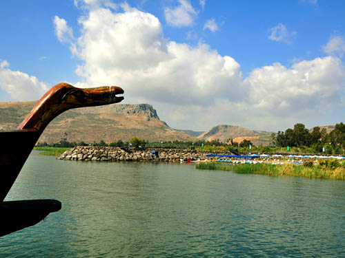
As we approached the shore I noticed one of the ships with an interesting figurehead of a bird, and captured this photo of the Via Maris, the road that leads from Migdal (Magdala) eastward.

The Via Maris from the Sea of Galilee at Nof Ginosar. Photo by Ferrell Jenkins.

The Via Maris from the Sea of Galilee at Nof Ginosar. Photo by Ferrell Jenkins.

The Sea of Galilee is extremely low. The area where you see the blue shade and cabanas now serves as a beach. A few years ago it was covered with water.

We did a lot more today, but that’s it for tonight. Everyone in the group appears to be in good health and enjoying the experience.