Category Archives: New Testament

Google Earth helps you see Biblical Sites

About a month ago Wayne Stiles posted an illustrated article about “Google Street View of 7 Biblical Sites.” There is some pretty neat stuff there, especially for those who have stood in these places and looked in all directions. Check all 7 views here.

Look at the photo below, and then see the same area in Google Earth.

The Western Wall, the Dome of the Rock, and the Mughrabi Gate are visible in this single photo. Photo by Ferrell Jenkins.

The Western Wall, the Dome of the Rock, and the Mughrabi Gate Bridge are visible in this single photo. Photo by Ferrell Jenkins.

Huge columns said to be 1900-years-old found buried at Laodicea

Hurriyet Daily News reported today the discovery of a large number of “1,900-year-old huge columns” at Laodicea.

Excavations in the Aegean province of Denizli’s ancient city of Laodicea have revealed 1,900-year-old huge columns seven meters underground. The columns were found in the area known as the northern agora, one of the oldest faith centers in Anatolia.

The head of the excavations, Professor Celal Şimşek, said the northern agora had been discovered last year and they were continuing restoration and conservation work there. He said the area was one of the largest agoras in Anatolia. “The columned galleries here are in a rectangular shape on an area of 35,000 square meters. We previously revived the columned galleries that we call the eastern porch. This year we found the extension of these columns seven meters underground. They were in the same condition as when an earthquake ruined them. The columns date back to 1,900 years ago. Dust erosion and residue have filled the earth here and preserved the columns.”

Şimşek said their goal was to finish the excavations by the end of the year and to revive the columns in the beginning of the next year. He said the ancient city of Laodicea had served as a religious center.

“When the columned galleries are completely unearthed, there will be a very nice touring area. Tourists will have the chance to see traces from the past up close.”

A nice gallery of photos illustrate the article. One is a drawing showing how the area may have looked before being destroyed by earthquake. We are given no hint how the age of the columns was determined and whether the earthquake that felled them was also about 1,900 years old. Mark Wilson says,

Because of earthquakes the city was rebuilt numerous times during its history. A devastating earthquake during the reign of Focas (AD 602-10) finally caused the site to be abandoned. The residents founded a new city called Ladik, now the Kaleiçi district of Denizli. — Biblical Turkey, 247.

Laodicea is mentioned only in Paul’s epistle to the Colossians (2:1; 4:13-16) and in the Book of Revelation (1:11; 3:14). Paul says that Epaphras worked diligently for the saints in Colossae, Laodicea, and Hierapolis. These were cities of the Lycus River valley.

We have visited Laodicea several times over the years and been delighted with the archaeological reconstruction underway. The city should be on everyone’s list of “must see” sites of Turkey. Turkey has approximately 1100 historical sites, and the country has made considerable progress in preparing some of them for visitors. Use the search box on this blog to locate previous entries about Laodicea.

Tourists on the Syrian Street at Laodicea. Colossae is located at the foot of Mount Cadmus, seen in the distance to the east. Photo by Ferrell Jenkins.

Tourists on the Syrian Street at Laodicea. Colossae is located at the foot of Mount Cadmus, seen in the distance to the east. Hierapolis is to the north (our left as we view the photo). Photo by Ferrell Jenkins.

HT: Joseph I. Lauer

The Sea of Galilee and Mount Arbel from the NW

This photograph of the Sea of Galilee and Mount Arbel was made from highway 807.

Sea of Galilee and Mount Arbel from the NW. Photo by Ferrell Jenkins.

The Sea of Galilee and Mount Arbel from the NW. Photo by Ferrell Jenkins.

From this point we can see the east side of the Sea of Galilee. Today we know it as the Golan Heights. In Old Testament times it was known as Bashan (Joshua 21:27). Golan was one of the cities of Refuge located in the area. In New Testament times this was the area of the Decapolis (Mark 7:31), and probably the country of the Gadarenes (Matthew 8:28).

Below Mount Arbel runs the Via Maris, the main road leading from the Turan Valley to Capernaum. This road allowed travel and commerce between Capernaum, Magdala, and Tiberias with the cities of Nazareth, Cana, Sepphoris, and Jotapata.

The Hermon (Banias) River and Falls

Names changes are fairly common in modern Israel. Scholars in the recent past have referred to the river that flows from Banias as the Nahr (River) Banias (Nelson Glueck, The River Jordan, 1945, p. 17).

The Nahr (River) Banias is the easternmost source of the River Jordan. The source of the Banias is located at a site we know as Caesarea Philippi in the New Testament. It is well known to those who study the ministry of Jesus (Matthew 16:13-19). The earlier Greeks carved the name of Pan on the rock and called the place Paneas. Glueck says,

The latter is the name that has endured to this day. The Arabs call it Banias, because every p becomes a b in their pronunciation.

Here is one of the photos I made during a clearing on a rainy day in mid-April.

The site of Caesarea Philippi. Photo by Ferrell Jenkins.

The site of Caesarea Philippi. Photo by Ferrell Jenkins.

The Israel Nature and Parks Authority now call this area the Hermon Stream Nature Reserve (Banias). At the point where the springs now emerges from the ground, this sign can be seen.

Sign at Banias denoting it as the Hermon River Springs. Photo by Ferrell Jenkins.

Sign at the source of the springs denoting them as the Hermon River Springs.

We shortly lose sight of the stream. About 2¼ miles southwest of the source, the stream emerges as the beautiful Banias (or Hermon) Waterfall.

The Banias (Hermon) Waterfall. Photo by Ferrell Jenkins.

The Banias (Hermon) Waterfall. Photo by Ferrell Jenkins.

As the river continues south, it soon merges with the other streams and becomes the famous Jordan River. I am rather certain in my mind that a decade or so ago this waterfall was identified as the Jordan River Fall. Technically, of course, it would still be the Banias or Hermon.

One can see why Israel would name the river the Hermon rather than call it by the Arab name Banias. But, it sometimes gets confusing — just like Bible translations of similar names.

The traditional site of Dalmanutha

Many tourists stop at Tabgha (Seven Springs, or Heptapegon) to see the mosaic of loaves and fish in the new Church of the Multiplication of the Loaves and Fishes. This church was built in 1982, but we know that a chapel was built at the site as early as the 4th century A.D. I will not engage in a discussion of whether this is the correct location for the feeding of the multitudes by Jesus.

Rarely does anyone have the opportunity to take the path from the church to the lake shore. This is private property. In the photo below, first notice that the water level is low. The green growth is covered when the water level is high. Notice also a path in the middle of the photos. This path leads from the church to the lake (when the water is high).

Traditional site of Dalmanutha (east of Tabgha). Photo by Ferrell Jenkins.

Traditional site of Dalmanutha (east of Tabgha). Photo by Ferrell Jenkins.

Only twice have I been able to reach the lake shore at this point. As one approaches the water there is a sign with the word Dalmanutha on it. I met Bargil Pixner in the book shop of the church in 1994 and have an inscribed copy of his with Jesus through Galilee according to the fifth Gospel. At least once in the book he mentions the Seven Springs as Ma-gadan, Tabgha (p. 37). The enlarged map in the back of the book marks the area as Ma-gadan (Dalmanutha).

Dalmanutha sign in 1994. Photo by Ferrell Jenkins.

Sign at traditional site of Dalmanutha in 1994. Photo by Ferrell Jenkins.

Sign at traditional site of Dalmanutha. Photo by Ferrell Jenkins.

Sign at traditional site of Dalmanutha in 2009. Photo by Ferrell Jenkins.

Here is the view from “Dalmanutha” toward Mount Arbel and the Horns of Hattin.

View from Dalmanutha toward Mount Arbel. Photo by Ferrell Jenkins 1994.

View from traditional Dalmanutha toward Mount Arbel. Photo by Ferrell Jenkins 1994.

I doubt that this identification is correct but thought it was significant enough to pass along.

We pointed out in a previous post here that Dalmanutha is mentioned only once in the Gospels.

And immediately he got into the boat with his disciples and went to the district of Dalmanutha. (Mark 8:10 ESV)

The parallel account in Matthew 15:32-39 says that Jesus came to the region of Magadan.

And after sending away the crowds, he got into the boat and went to the region of Magadan.  (Matthew 15:39 ESV)

In search of Dalmanutha

After the feeding of the four thousand, Jesus went to the district of Dalmanutha.

And immediately he got into the boat with his disciples and went to the district of Dalmanutha. (Mark 8:10 ESV)

This is the only Biblical reference to a place called Dalmanutha. Where was it? When we read the parallel account in Matthew 15:32-39, we learn that Jesus came to the region of Magadan.

And after sending away the crowds, he got into the boat and went to the region of Magadan.  (Matthew 15:39 ESV)

Todd Bolen, at Bible Places Blog, notes that some scholars equate Dalmanutha with Magadan/Magdala. He says,

Mendel Nun has proposed that Dalmanutha be identified with a small anchorage north of Magdala (Anchor Bible Dictionary 2:4). Dalmanutha may not be a proper name but simply the Aramaic word for harbor.

In an article on “Ancient Harbors Of The Sea Of Galilee,” Gordon Franz discusses the location of Magdala/Dalmanutha. Perhaps Dalmanutha “is a transliteration of the Syrian word for harbor.” Or, the term may derive from the harbor that existed here. Franz describes the harbor:

It consisted of two parts; an open dock for loading and unloading during the summer, and a basin, with a 70 m breakwater to protect the ships from the winter storms. (Bible and Spade (1991) Volume 4, 04. p. 120.)

This new discussion about Dalmanutha has been prompted by a recent lecture by Dr. Ken Dark at the Centre for the Study of Christian Origins in the School of Divinity, University of Edinburgh. Helen Bond reports here that Dark spoke of mapping the area around Nazareth and the Sea of Galilee. Notice the summary of Dark’s comments on Dalmanutha:

A new research project is synthesising existing data and using air- and satellite-photography to re-examine the area, combined with the first extensive archaeological survey of the Ginosar valley. The latter has identified a very large, but previously-unrecognised, Late Hellenistic, Roman-period, and later, settlement between the modern town of Migdal (on the western side of the valley) and the coast, just south of Kibbutz Ginosar.  It is hard to imagine that a Roman-period coastal community of this size is nowhere mentioned in textual sources, and the site might be identified with one of the unlocated toponyms known from the Bible, perhaps the Dalmanutha of Mark 8:10.

The aerial photo below shows the general area under consideration. Magdala is on the left of the photo. On the right you can see the museum at Nof Ginosaur where the Roman Boat is shown. Part of the building is hidden behind the wing strut of the airplane.

Aerial view of the Plain of Genessaret from Magdala on the south (left) to Nof Ginosaur on the north (right). Photo by Ferrell Jenkins.

Aerial view of the Plain of Genessaret from Magdala on the south (left) to Nof Ginosaur on the north (right). Photo by Ferrell Jenkins.

The green strip between the water and the land is covered by water this year. You see two places where the growth has been cleared away to make room for a beach.

So, we have several options for the location or meaning of Dalmanutha. In a post to follow I will show you the traditional site of Dalmanutha.

HT: Bible Places Blog; Larry Hurtado’s Blog

A synagogue on the island of Delos

In the previous post we mentioned that there were numerous synagogues used by Jews of the Diaspora. Paul visited synagogues in many of the cities where he preached.

During his Spring travels, Dr. Carl Rasmussen visited the Greek island of Delos. Delos is one of those places that can only be reached with much effort. Carl has graciously granted permission for me to use a couple of his photos here. The first one shows a view to the west, southwest, showing various rooms of the synagogue. Note the “Moses Seat” in the upper right of the photo. The entrance is visible in the lower left.

Delos synagogue. Photo by HolyLandPhotos.

Delos synagogue. Photo by Carl Rasmussen, HolyLandPhotos.

The second photo shows a close up of the “Moses Seat” and the marble seats on each side. You may click on the photos for larger images provided by Dr. Rasmussen at the HolyLandPhotos’ Blog.

Delos synagogue. Photo by Carl Rasmussen, HolyLandPhotos.

Delos synagogue. Photo by Carl Rasmussen, HolyLandPhotos.

This large synagogue dates to the mid-second century B.C. Two inscriptions found in 1979-80 indicate that the worshipers here (Israelites) were likely Samaritans who revered Argarizein (Mount Gerizim). (See Kraabel, “New Evidence of the Samaritan Diaspora has been Found on Delos.” BA 47:1; 1984).

The Moses Seat. We commonly identify a special seat like the one in this synagogue as the Seat of Moses. Jesus may have made reference to such a seat (Matthew 23:2-3). For more information about the “Moses Seat” see here. Michael White suggests at least the possibility that this seat may be a “Proedrion, either for the major donor (or patron) or for the leader of the group” (HTR 80:2 (1987). I don’t see that this changes the fact that a reader and teacher of the Law might sit here.

If you have any interest in the synagogues scattered over the Mediterranean world, you will want to visit the HolyLandPhotos’ Blog here.

Tradition has it that Delos is the birthplace of Apollo, the son of Zeus, and his twin sister Artemis.

Marble head of Apolls from Perga. Second century A.D. Photo by Ferrell Jenkins.

Marble head of Apolls from Perga. Second century A.D. Photo by Ferrell Jenkins in the Antalya Archaeological Museum.

An article by Gordon Franz a few years ago piqued my interest in Delos. He wrote on “The Synagogue On The Island Of Delos And The Epistle Of James” in Bible and Spade (18:3; 2005). Franz provides the history and geography of the island. He includes a photo of the “Samaritan inscription,” and then proceeds to use the synagogue of Delos to illustrate two passages from the Epistle of James. He discusses James 2:2-4 and selected verses from James 3.

For those who have an interest in visiting Delos, Prof. Rasmussen explains exactly how to reach the synagogue from the Delos Museum. Rasmussen is author of the Zondervan Atlas of the Bible, and provides nearly 4000 thousand photos at the Holy Land Photos archive.

The synagogue — a place of study and discussion

The origin of the synagogue is difficult to determine, but it is generally held that it arose during the time of the Babylonian exile. Synagogues did not become common until the intertestamental period. The term intertestamental is used by many writers to describe the period between the close of the Old Testament (about 425 B.C.) and the coming of John the Baptist in the early first century A.D. Others use the term interbiblical, or the longer phrase, between the testaments.

With the destruction of the Temple (586 B.C.), sacrifices ceased. Prayer and the study of the sacred Scriptures, however knew no geographical limitations. The Book of Ezekiel describes the elders of Israel gathering in the prophet’s house (8:1; 20:1-3) (Charles Pfeiffer, Between the Testaments, 59).

In the sixth year, in the sixth month, on the fifth day of the month, as I sat in my house, with the elders of Judah sitting before me, the hand of the Lord GOD fell upon me there. (Ezekiel 8:1 ESV)

In the seventh year, in the fifth month, on the tenth day of the month, certain of the elders of Israel came to inquire of the LORD, and sat before me. And the word of the LORD came to me: “Son of man, speak to the elders of Israel, and say to them, Thus says the Lord GOD, Is it to inquire of me that you come? As I live, declares the Lord GOD, I will not be inquired of by you. (Ezekiel 20:1-3 ESV)

The word synagogue is of Greek origin. It simply refers to a gathering of the people, or a congregation. “The Hebrew word for such a gathering is keneseth, the name used for the parliament in the modern state of Israel” (Pfeiffer, 59).
After the rebuilding of the Temple (520–516 B.C.), the synagogue continued to fill the spiritual needs of the Jews of the Diaspora. There were synagogues in many of the cities visited by Paul: Damascus (Acts 9:2); Salamis (13:5); Antioch of Pisidia (13:14); Thessalonica (17:1); Corinth (18:4); Ephesus (19:8), and others. Only ten families were needed to compose a synagogue.

In 1898 a partial inscription mentioning a “synagogue of the Hebrews” was found at Corinth. It was published by Benjamin Powell in 1903 and identified as having come from the synagogue where Paul preached. McRay says that further study showed that it should be dated considerably later than the time of Paul. (Archaeology and the New Testament, p. 319).

Synagogue Inscription displayed in Corinth Museum. Photo by Ferrell Jenkins.

Synagogue Inscription displayed in Corinth Museum. Photo by Ferrell Jenkins.

A small plaque mounted underneath the inscription at the Corinth Museum reads, “Inscription from a late Roman synagogue.”

One rabbinic tradition has it that there were 480 synagogues in Jerusalem alone. Even the small villages of Galilee had synagogues at the time of Jesus (Mt. 4:23; 9:35).

More about Ephraim

In the previous post we pointed out that Ephraim, where Jesus went a short time before His death (John 11:54), is identified with Taybeh on the edge of the wilderness.

Ephraim is included on the Madaba Map dating to about 560-565 A.D. Below is a photo of a portion of the Madaba Map. The large town with palm trees around it represents Jericho. Below Jericho the land color changes to black. The entry closest to Jericho, but a little to the right, is Ephraim.

According to the website dealing with The Madaba Map, provided by the Studium Biblicum Franciscanum – Jerusalem, the two lines of white lettering read,

Ephron also Ephraia, where went the Lord

Portion of the Madaba Map mentioning Ephron. Photo by Ferrell Jenkins.

Portion of the Madaba Map mentioning Ephron. Photo by Ferrell Jenkins.

Here is a larger cropped portion of the map identifying Ephron. If your Byzantine Greek is up to date, you can make out all of the words.

Closeup of Ephron reference in Madaba Map. Photo by Ferrell Jenkins.

Closeup of the Ephron reference in Madaba Map. Photo by Ferrell Jenkins.

The inscription is located close to the wilderness, but is too far south. Other similar mistakes are made on the map. One such example would be the location of Ebal and Gerizim (See Victor R. Gold. “The Mosaic Map of Madaba.” Biblical Archaeologist, Sept. 1958: 50-71).

Ruins of a Byzantine church remain at Taybeh. There are also Crusader ruins. The Madaba Map from Jordan reflects the traditions of the 6th century A.D. Add this to the biblical evidence we mentioned equating Ephron, Ophrah, and Ephraim, and we have strong evidence that Taybeh marks the site of Ephraim.

Barry Britnell pointed out that Google Maps spell the name of Taybeh as Taibe.

You may read more about the Madaba Map section on Ephron here. Click on Ancient Sources for quotations from Eusebius and Josephus. Also check the Discussion section for more explanation.

William F. Albright suggested, as early as 1924, that Ephraim was to be identified with En Samye (Ein Samiyeh), a few miles northeast of Taybeh. Well, that gives me another place to visit in the future.

Jesus withdrew to Ephraim

The raising of Lazarus of Bethany brought much attention to Jesus and His ministry (John 11). According to John’s account, beginning in verse 45, many who saw the sign believed on Him. This caused the chief priests and Pharisees to convene a council. They were concerned about what the Romans might do if Jesus continued His work. Caiaphas, the high priest that year, told the council that it would be better for one man to die than for the whole nation to perish. In fact, John says this was a prophecy that Jesus was going to die for the nation. The text says,

So from that day on they made plans to put him to death. (John 11:53 ESV)

Jesus had other plans. Jesus carefully orchestrated His death. From the beginning of His ministry He spoke of His hour. After the raising of Lazarus he withdrew to a place northwest of Jerusalem on the edge of the wilderness at Ephraim.

Jesus therefore no longer walked openly among the Jews, but went from there to the region near the wilderness, to a town called Ephraim, and there he stayed with the disciples. (John 11:54 ESV)

Jesus would offer Himself as the sacrificial lamb at the time of the Passover. This took intricate planning.

Where is this place called Ephraim?

The identity of this place is complicated, partly because of the obscurity of the place and because of the change of names in the various languages that have prevailed in the territory over the centuries. Let’s try to work through some of the details.

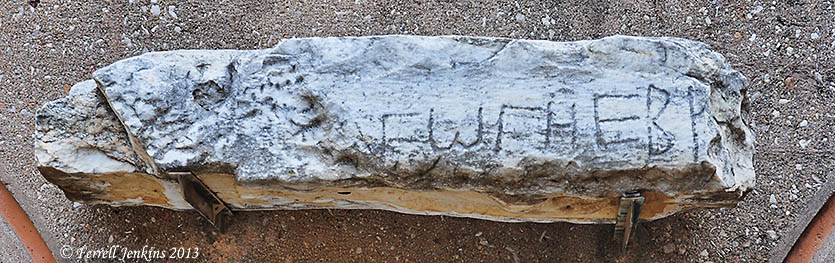
Baal-hazor, where Absalom had sheep shearers, is said to be near Ephraim (2 Samuel 13:23).

The Ephron of 2 Chronicles 13:19 is often identified with Ephraim and the Ophrah of Joshua 18:23. Ophrah was in the tribal territory of Benjamin and near Bethel. Ophrah, which we are equating with Taybeh (tie-BAY), is only 4 miles north-east of Bethel and about 15 miles from Jerusalem.

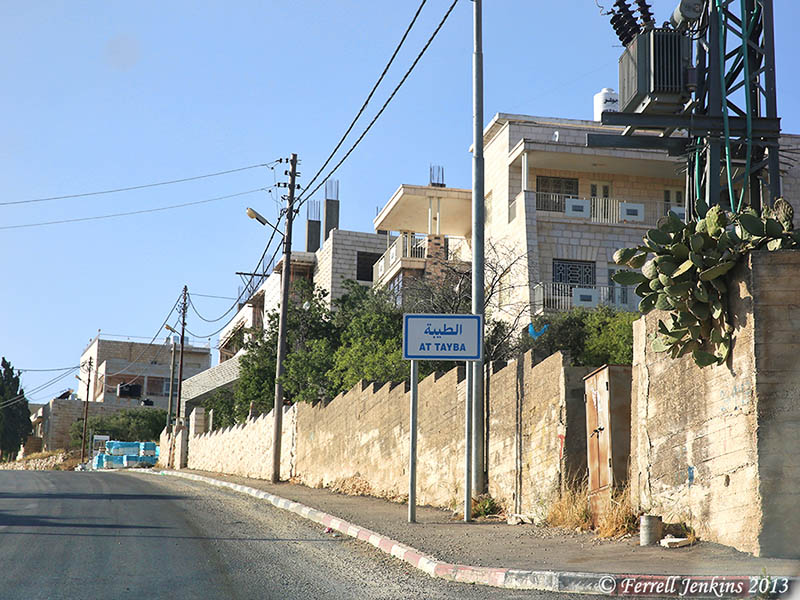
What is the name of Ephraim today? Ephraim is often identified with a Christian Arab town in the West Bank Palestinian territory known as At-Taybe. On Highway 60 a sign points to Taybeh, the spelling I am using. Carta’s Israel Touring Atlas spells it Et-Tayibeh.

Checking the Maps. Taybeh should be reached easily from Highway 60 by taking Highway 449 east at Ofra, and then a smaller road to the village. This is not possible. Ofra is an Israeli settlement, and the road is blocked for those wishing to go to Taybeh. Instead, it is necessary to take Highway 457 east, then 458 north. At the intersection with 449 (east), take the small road to the left to reach Taybeh. Highway 449 leads to the Jordan Valley and Jericho. The paved road is only wide enough for one vehicle at places and is in bad repair.

Entering the Christian village of At Taybe. Photo by Dan Kingsley.

Entering the Christian village of At Tayba. Photo by Dan Kingsley.

Gustaf Dalman says,

This et-Tayibeh, whose ancient name was, according to the villagers’ own recollections, ‘Afra’… (Sacred Sites and Ways, 1935, page 217).

Yoel Elitzur, says there is a surviving tradition that Taybeh was known in the past as Afra. He cites the work of Lydia Einsler from 1893, and then says that he,

…personally heard myself in the village, from speakers of various ages and levels of education. (Ancient Places Names in the Holy Land, 2004, page 268).

Note the similarity in the pronunciation of Oprah, Ephron, Afra, and Ephraim.

A book I have enjoyed for several decades is Eugene Hoade’s Guide to the Holy Land, published by the Franciscan Printing Press in Jerusalem. There is no date in the book, but I have owned it for several decades. Google books lists this book of 823 pages as having been published in 1984.

Hoade says that Taybeh is 869 meters in elevation. This equates to 2851 feet, about 400 feet higher than Jerusalem. He says that Taybeh is,

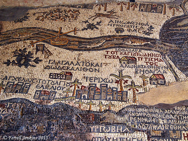
a Christian village, those inhabitants claim that they have been Christian from the very beginning. There is a flourishing Latin parish (1860): the Rosary Sisters have the Girl’ School since 1908: there is a Greek Orthodox Church, under which is a mosaic. The Greek Catholics built the new church of St. George in 1964, and the Latins are in the process of building a new church, which has a beautiful mosaic in the apse, representing the people meeting Jesus. (page 545)

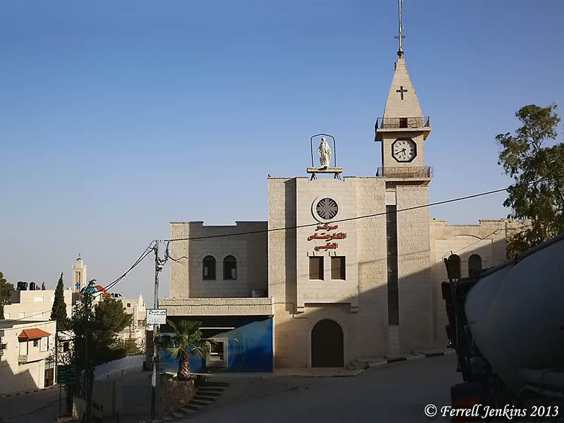
We drove to the top of the hill and the end of the village, turned around, and made a photo of what I think may be the Latin church and school.

The Latin Church at Taybeh. Photo by Dan Kingsley.

The Latin Church at Taybeh. Photo by Dan Kingsley.

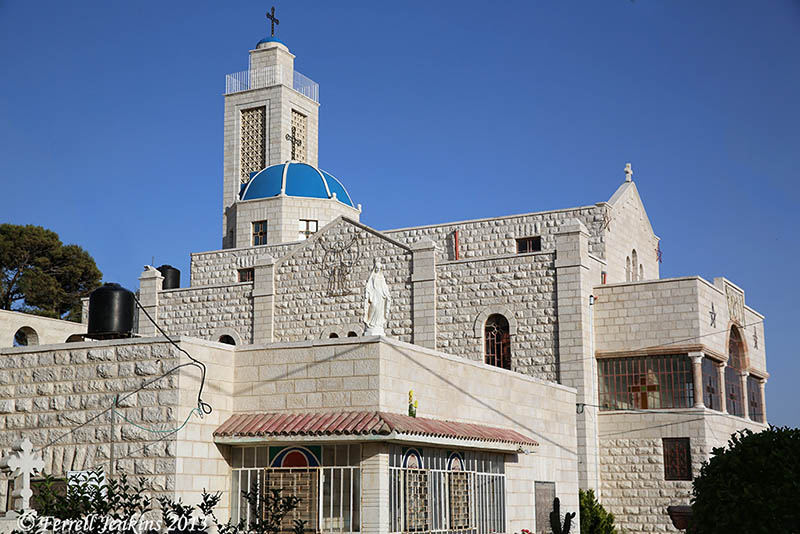
The Greek Catholic (Melkite) church of St. George was built in 1964. On the hill behind this church may be found the ruins of a Byzantine church.

Greek Orthodox church at Taybeh. Photo by Dan Kingsley.

Greek-Melkite church at Taybeh. Photo by Dan Kingsley.

From the ridge on which Taybeh is built, the wilderness can be seen to the east. This is similar to the view that many of you have seen from the Mount of Olives, or from the Herodium, when you look to the east. The photo below shows the view east of Taybeh.

Wilderness to the east of Taybeh. Photo by Dan Kingsley.

Wilderness to the east of Taybeh. Photo by Dan Kingsley.

In reading about Taybeh, I have learned that all of the churches keep the Western Christmas and the Eastern Easter.

I have credited all of the photos to my traveling companion Dan Kingsley. Because we had little time to linger, we agreed that Dan would make the photos, sometimes from the car window, and we would share them. I have cropped and enhanced them as needed.