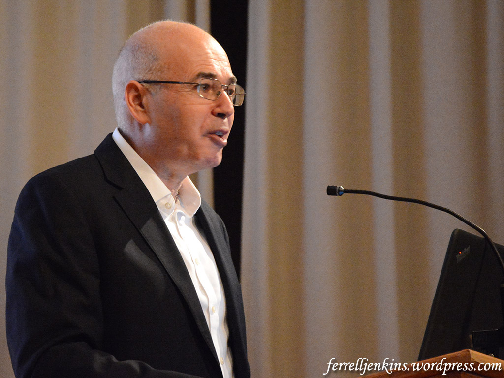
Prof. Yosef Garfinkel spoke last evening to an appreciative audience of about 200 students, faculty, and visitors at Florida College, Temple Terrace, Florida. Garfinkel is Yigael Yadin Chair in Archaeology of Israel at the Hebrew University of Jerusalem. His archaeological work has specialized in the Neolothic period, the Chalcolithic period, and the Biblical kingdom of Judah.
Prof. Yosef Garfinkel speaking at Florida College. Photo by Ferrell Jenkins.
This was Prof. Garfinkel’s second time to speak at Florida College. This came about as a result of the archaeological participation of Luke Chandler in two recent projects directed by Garfinkel, the work at Khirbet Qeiyafa and at Tel Lachish. Those of you who follow Chandler’s blog will have some insight into this work. Luke has taken several Florida College faculty members, students, and alumni, to participate in these digs.
Yossi, as he is known to many, spoke of the need for regional research, to examine when “the Kingdom of Judah spread into the Shephelah (south and west of Jerusalem.” Khirbet Qeiyafa, a brief study at Khirbet Arai, and the fourth expedition to Lachish are being used to answer this question.
The archaeologist told how he chose where to begin the fourth Lachish expedition. He chose the northeast corner because of access to water, fertile lands, and a road. He thought this would be an ideal location for a city gate. Indeed, a gate has been located in the area. Through the use of some excellent aerial photographs he showed the location of this recent work.
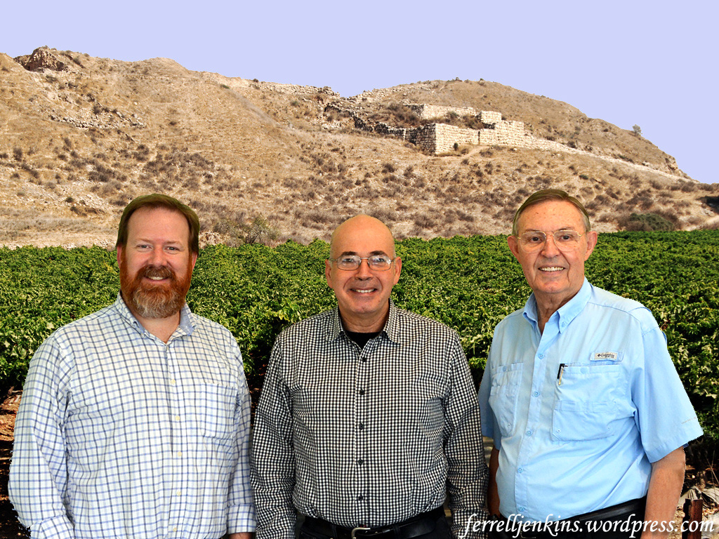
Earlier in the day Luke and I had lunch with Prof. Garfinkel at a nice local restaurant near Florida College.
Luke Chandler, Yosef Garfinkel, and Ferrell Jenkins with a backdrop of Tel Lachish.
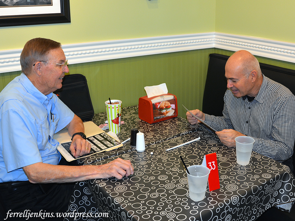
I took along some black and white photos and contact prints made at Tel Lachish during the third expedition to Tel Lachish in 1980 when four Florida College faculty members (Jenkins, Jim Hodges, Phil Roberts, and Harold Tabor) participated in the dig. That project was under the direction of David Ussishkin. I expected Yossi to say, “You haven’t aged much,” when he saw a photo of the four of us with Prof. Ussishkin, but instead he said, “Is that David?” 🙂
Looking over black and white photos from Lachish made in 1980. Photo by Luke Chandler.
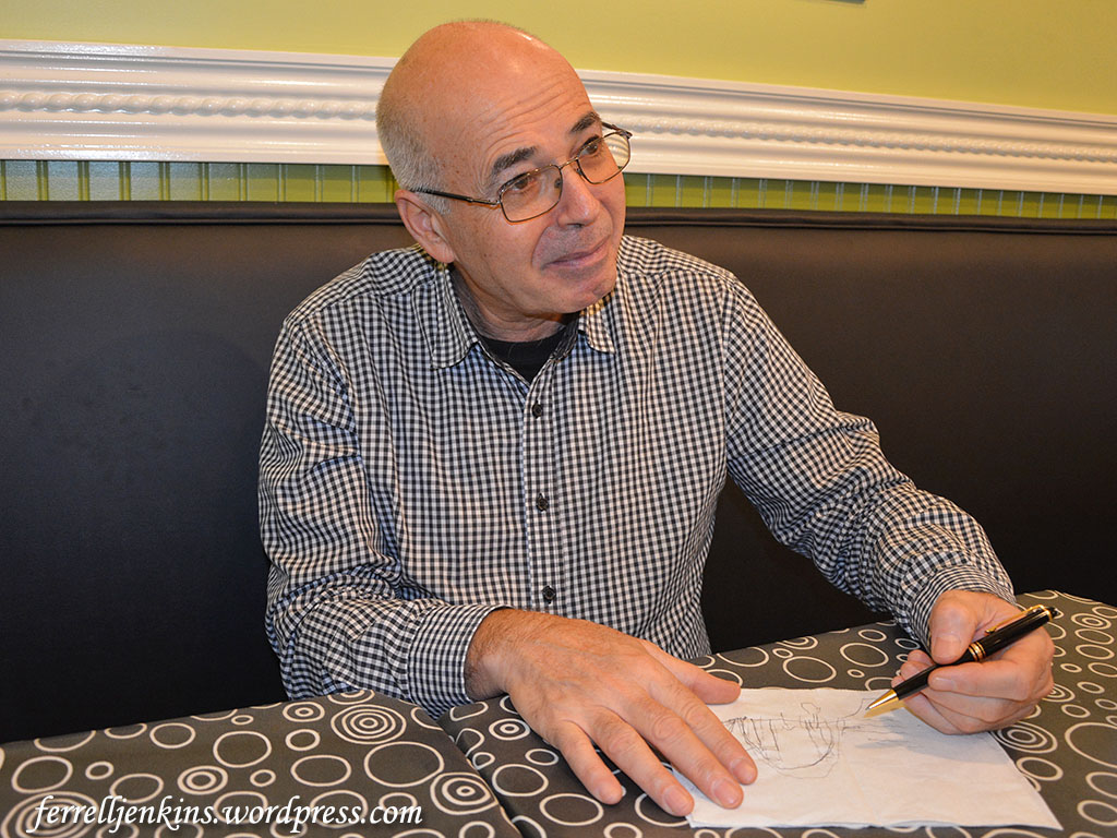
While we were waiting for our lunch we inquired about the progress on a water shaft or tunnel at Tel Lachish. Prof. Garfinkel took a napkin and drew a sketch of the area. We got our lunch but are still waiting patiently for a water system to be revealed at Lachish.
Prof. Garfinkel draws a sketch of the area where he thought a water shaft might be found at Tel Lachish. Photo by Ferrell Jenkins.
The Biblical Studies faculty shared a dinner with Prof. Garfinkel prior to his 7 p.m. lecture. I was pleased to be included, along with Luke and his family.
There are several posts on this blog about Lachish. Just use the search box to locate them.
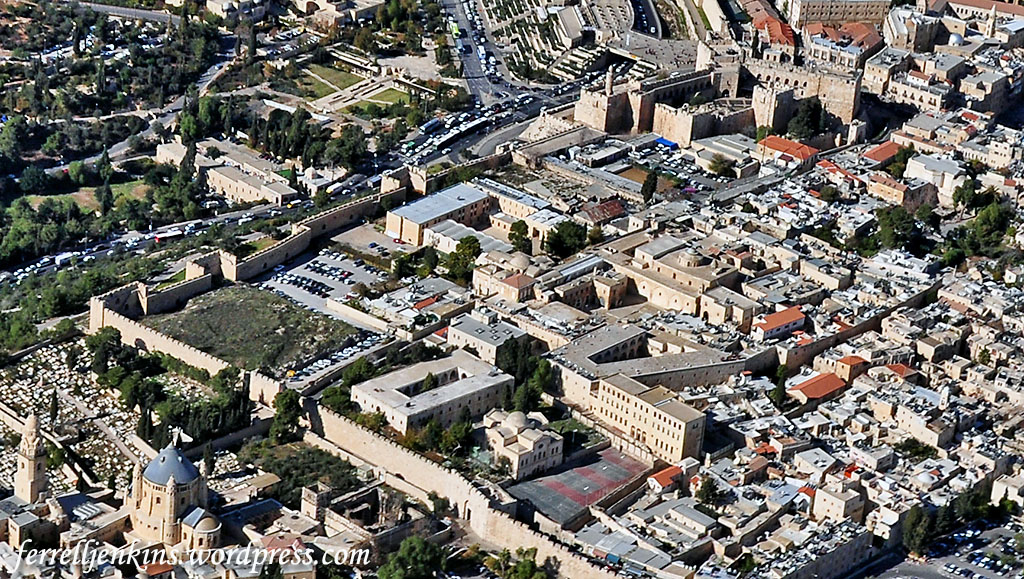
Read our first post about the Citadel of Jerusalem here.
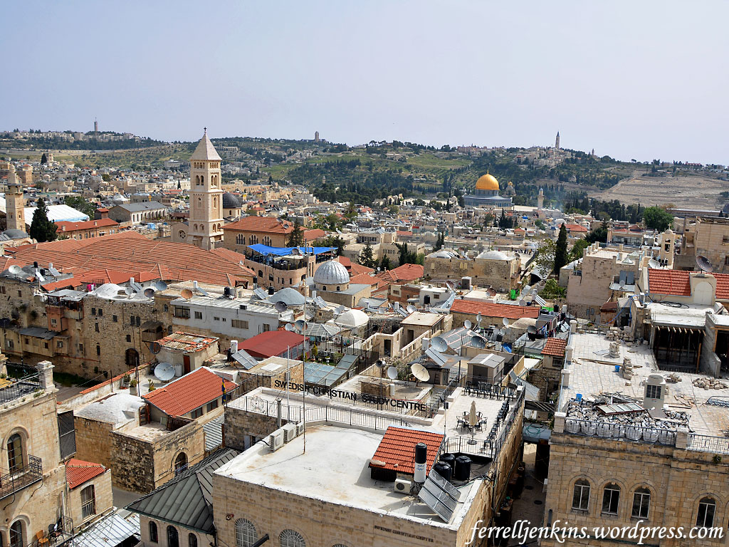
Our main reason for visiting the Citadel on the most recent trip was to visit the newly opened Kishle (Prison). As a part of the tour we took at the Citadel we went to the top of the Tower of David (sometimes called the Tower of Herod) for a view of the Old City of Jerusalem.
The first view looks east. The pyramidal tower in the left foreground belongs to the Christ the Redeemed Lutheran Church. A climb to the top of that tower also provides a wonderful view across the city. In the distance to the right of center is the easily recognizable Mosque of Omar, commonly known as the Dome of the Rock. This is where the Temples of Solomon and Herod stood in Bible times (see Ritmeyer, Jerusalem The Temple Mount, 16-17).
Notice the mountain range to the east. You already know that the Citadel, the highest part of the Old City is more than 2500 feet above sea level, but the mountain range to the east is more than 100 feet higher than the area of the Citadel. There are three towers on the mountain range. On the left (north) is Mount Scopus. To the south you will see the tower of the Augusta Victoria Hospital. Finally, further south is the Tower of the Church of Ascension on the Mount of Olives.
Beyond the Mount of Olives lies the Wilderness of Judea which stretches down to the Jordan Valley and Dead Sea.
This is a view east from the Tower of David. Photo by Ferrell Jenkins.
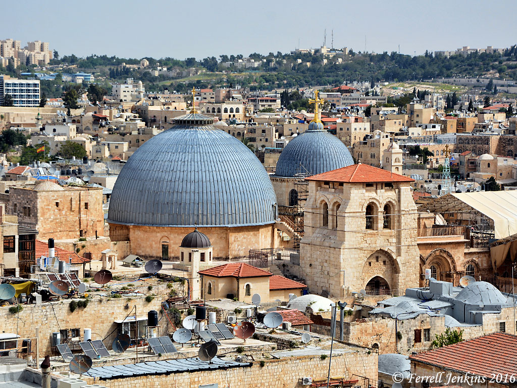
There are many wonderful views from the Citadel Tower. This view is slightly north and provides a look at the two domes of the Church of the Holy Sepulchre. The large dome covers the traditional tomb of Jesus and the smaller dome is nearer to the traditional site of Calvary.
The domes of the Holy Sepulcher from the Tower of David. Photo by Ferrell Jenkins.
In most of these views you may notice the mountains surrounding Jerusalem. This reminds us of the statement of the Psalmist.
As the mountains surround Jerusalem, so the LORD surrounds his people, from this time forth and forevermore. (Psalm 125:2 ESV)
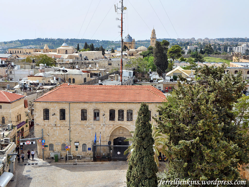
The prominent building in the photo below is the Kishle. This building was used by the Ottomans and the British as a prison. It now serves as the Police Station of the Old City. (Click on the photo for a larger image.)
Notice the small street to the left of the Police Station. That street runs through the heart of the Armenian Quarter of the Old City. In the distance, to the left of the street and photo there is a square building with a dome. That is the roof of the Armenian church, St. James Cathedral. Armenian tradition has it that James the brother of Jesus is buried there.
Notice the pole with several antennas on it. The building in the distance to the right of the pole is the Church of the Dormitian. It is outside the southern wall of the Old City.
Look now to the right side of the photo where you see a grassy knoll and a portion of the southern wall.
Remember that this photo is made from the Tower of David (or Herod) in the Citadel. The area stretching south from the citadel to the southern wall is now known as the Armenian Garden. It is thought by some archaeologist to be the area of Herod’s Palace and the military barracks. This, of course, would make it the area of the Praetorium and the place of Jesus trial. I suggest Shimon Gibson’s “The Trial of Jesus at the Jerusalem Praetorium: New Archaeological Evidence” in Craig A. Evans, Ed., The World of Jesus and the Early Church (Peabody: Hendrickson 2012). The volume on Jerusalem Revealed that we mentioned in the earlier post also has information on this subject.
View looking south from the Tower of David. The building in the foreground is the police station. Photo by Ferrell Jenkins.
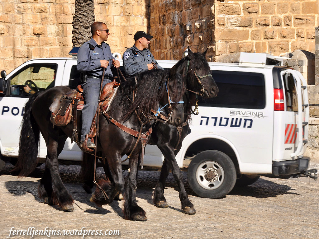
Some mounted police work out of this police station. If you have ever walked the narrow stepped streets of the Old City you know what this might be the best mode of transportation for the police officers.
Mounted police in front of the prison. Photo by Ferrell Jenkins.
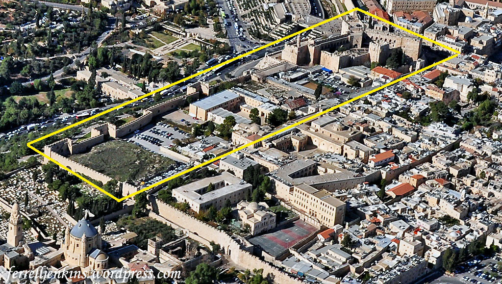
We will close with an aerial view of the Armenian Quarter of the Old City of Jerusalem. The Citadel can be seen in the upper right quarter of the photo.
Aerial view of the Armenian Quarter. The area marked in yellow is the area of Herod’s Palace. Photo by Ferrell Jenkins.
In the next photo I have marked the Citadel and the area south to the southern wall of the Old City. This view is from the southeast to the northwest.
Aerial view of the Armenian Quarter. The area marked in yellow is the area of Herod’s Palace. Photo by Ferrell
The area of Herod’s Palace is thought to have extended east of (right) the boundary I have drawn, but the buildings there make it impossible to carry out further excavations.
In the next post on the Citadel we plan to take you to see the Kishle excavations.
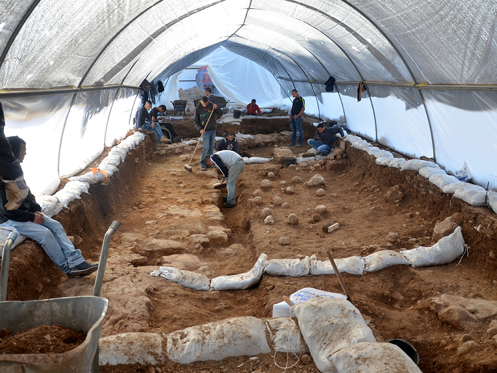
We have been awaiting the unveiling of this document for several days. A leaked account made it to the papers a couple of days ago, but I decided to wait until we had official word from the Israel Antiquities Authority. Today we have this information.
— “ —
In a complex enforcement operation, inspectors of the Israel Antiquities Authority seized a papyrus that includes the earliest reference to Jerusalem in an extra-biblical document, which is written in ancient Hebrew script and dates to the time of the Kingdom of Judah.
The find was revealed this morning (Wednesday) in a press [release] of the Israel Antiquities Authority
A rare and important find was exposed in an enforcement operation initiated by the IAA’s Unit for the Prevention of Antiquities Robbery: a document written on papyrus and dating to the time of the First Temple (seventh century BCE) in which the name of the city of Jerusalem is clearly indicated. This is the earliest extra-biblical source to mention Jerusalem in Hebrew writing.
The document, which was illicitly plundered from one of the Judean Desert caves by a band of antiquities robbers and was seized in a complex operation by the IAA’s Unit for the Prevention of Antiquities Robbery, was presented today (Wednesday) in a press [release] of the Israel Antiquities Authority.
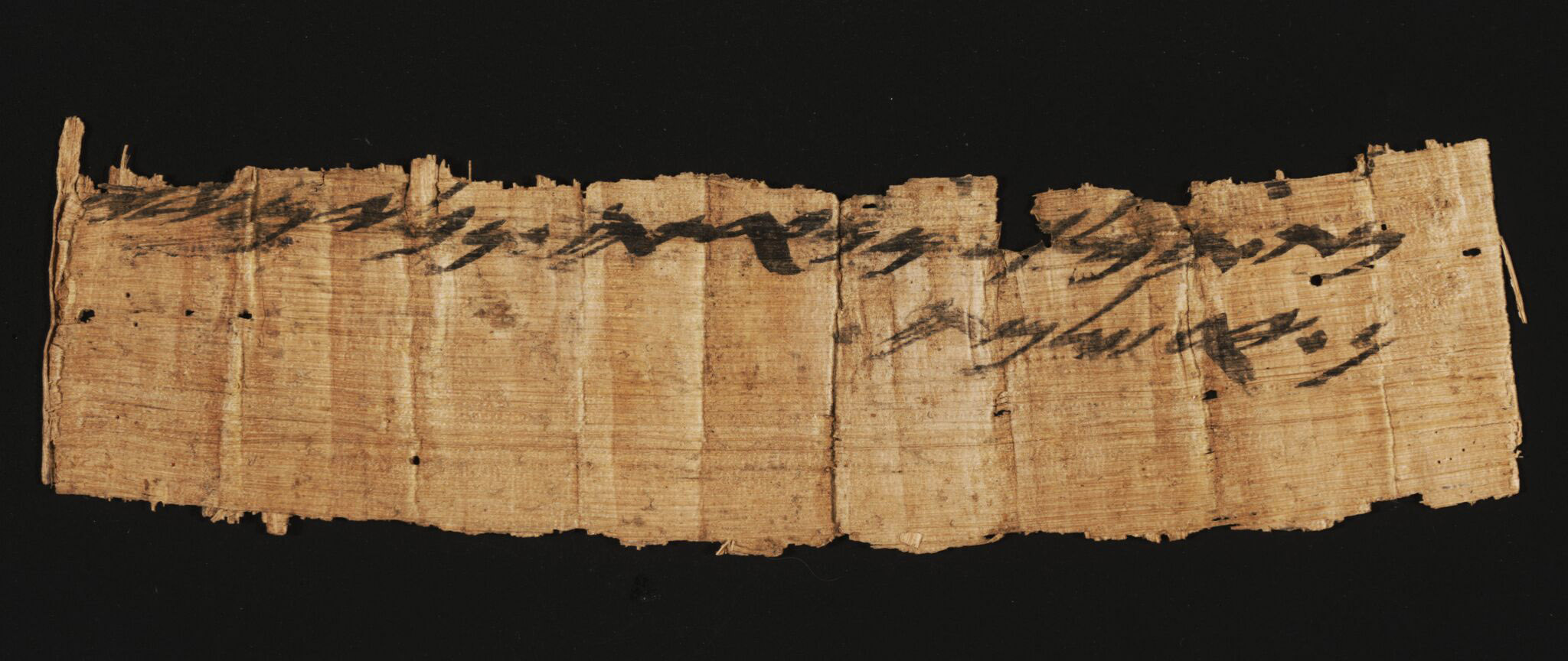
Rare 7th century B.C. Hebrew papyrus document bearing the name of Jerusalem. Photo Shai Halevi, Israel Antiquities Authority.
Two lines of ancient Hebrew script were preserved on the document that is made of papyrus (paper produced from the pith of the papyrus plant [Cyperus papyrus]). A paleographic examination of the letters and a C14 analysis determined that the artifact should be dated to the seventh century BCE – to the end of the First Temple period. Most of the letters are clearly legible, and the proposed reading of the text appears as follows:
From the king’s maidservant, from Naʽarat, jars of wine, to Jerusalem
This is a rare and original shipping document from the time of the First Temple, indicating the payment of taxes or transfer of goods to storehouses in Jerusalem, the capital city of the kingdom at this time. The document specifies the status of the sender of the shipment (the king’s maidservant), the name of the settlement from which the shipment was dispatched (Naʽarat), the contents of the vessels (wine), their number or amount (jars) and their destination (Jerusalem). Naʽartah, which is mentioned in the text, is the same Naʽarat that is referred to in the description of the border between Ephraim and Benjamin in Joshua 16:7: “And it went down from Janohah to Ataroth, and to Naʽarat, and came to Jericho, and went out at Jordan”.
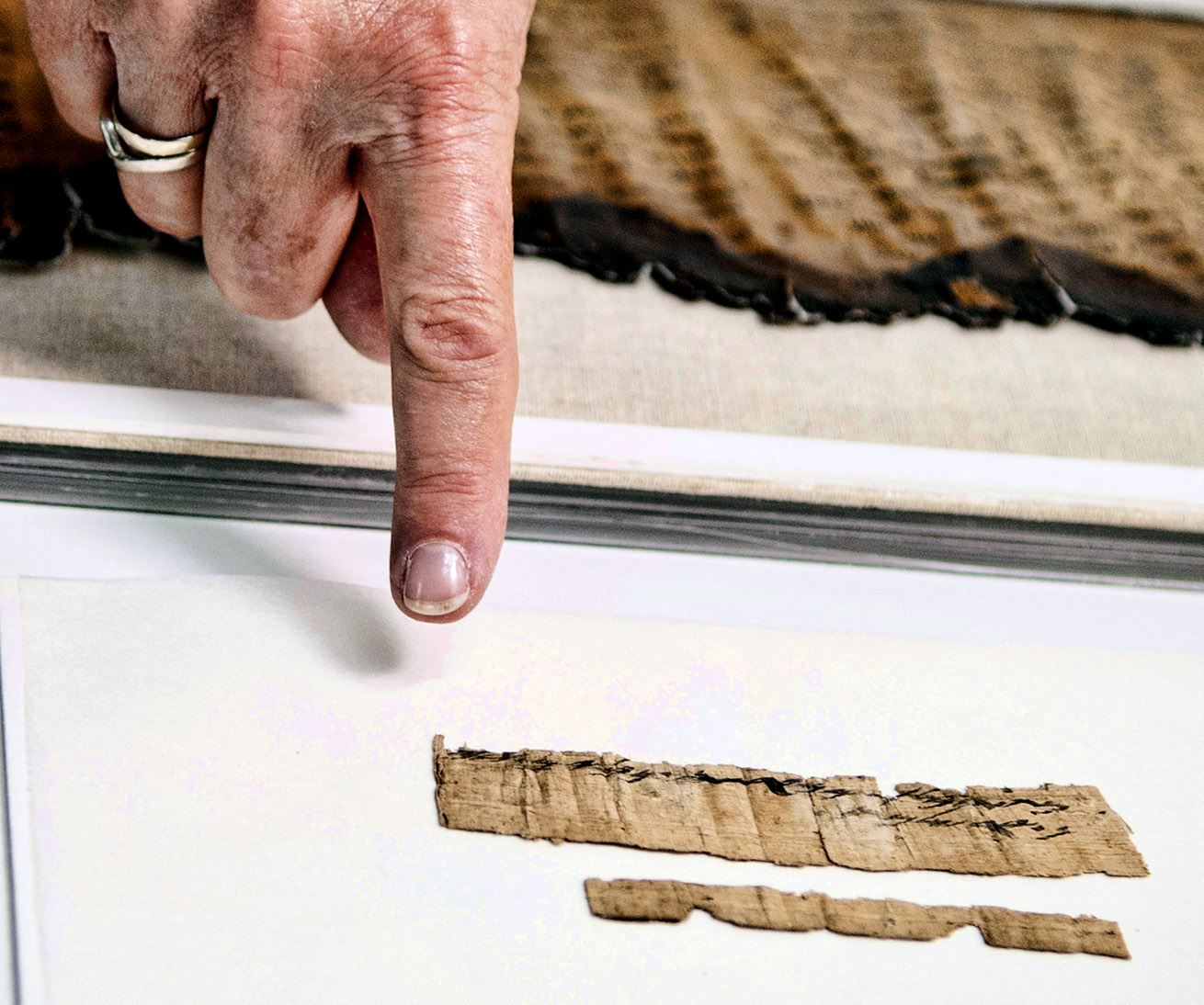
Hebrew papyrus document from 7th century B.C. preserved by the Israel Antiquities Authority. Photo by Shai Halevi.
According to Dr. Eitan Klein, deputy director of the IAA’s Unit for the Prevention of Antiquities Robbery, “The document represents extremely rare evidence of the existence of an organized administration in the Kingdom of Judah. It underscores the centrality of Jerusalem as the economic capital of the kingdom in the second half of the seventh century BCE. According to the Bible, the kings Menashe, Amon, or Josiah ruled in Jerusalem at this time; however, it is not possible to know for certain which of the kings of Jerusalem was the recipient of the shipment of wine”.
Israel Prize laureate and biblical scholar Prof. (Emeritus) Shmuel Ahituv attests to the scientific importance of the document, “It’s not just that this papyrus is the earliest extra-biblical source to mention Jerusalem in Hebrew writing; it is the fact that to date no other documents written on papyrus dating to the First Temple period have been discovered in Israel, except one from Wadi Murabbaʽat. Also outstanding in the document is the unusual status of a woman in the administration of the Kingdom of Judah in the seventh century BCE”.
According to Israel Hasson, director of the Israel Antiquities Authority, “The discovery of the papyrus shows that there are other artifacts of tremendous importance to our heritage that are waiting to be found in the Judean Desert caves. The world’s heritage assets are being plundered on a daily basis by antiquities robbers solely for greed. The state has to mobilize and allocate the necessary resources in order to embark upon a historic operation together with the public, and carry out systematic excavations in all of the Judean Desert caves.”
According to the Minister of Culture and Sport, MK Miri Regev, “The discovery of the papyrus on which the name of our capital Jerusalem is written is further tangible evidence that Jerusalem was and will remain the eternal capital of the Jewish people. It is our duty to take care of the plundering of antiquities that occurs in the Judean Desert, and no less important than this is exposing the deceit of false propaganda as is once again happening today in UNESCO. The Temple Mount, the very heart of Jerusalem and Israel, will remain the holiest place for the Jewish people, even if UNESCO ratifies the false and unfortunate decision another ten times”.
Amir Ganor, director of theIAA’s Unit for the Prevention of Antiquities Robberyexplained “Organic material, such as documents, particularly delicate paper like papyrus, perish over time due to their sensitivity to moisture. The dry climate of the desert is exceptional in that it facilitates the preservation of documents that provide invaluable information regarding the way of life in antiquity and the early development of religions. The rarity of the finds and their importance are the reasons why the antiquities robbers risk their lives coming to dig in the caves in the desert cliffs. I am glad that we were fortunate to have a role in saving the papyrus, which is an important and special find that bears witness to the historical relationship between the Land of Israel and Jerusalem, and the Jewish people”.
According to Pnina Shor, curator and director of the Dead Sea Scrolls project at the Israel Antiquities Authority, “This unique papyrus joins the thousands of scroll fragments for which the Israel Antiquities Authority established dedicated conservation and photographic laboratories where the scrolls are treated using highly sophisticated means and the most advanced documentation and photographic technology available today. With a state-of-the-art camera that was developed based on technology used by NASA which records the Dead Sea Scrolls at a level that replicates the original, it is even possible to see the texture of the plant, skin or parchment on which the ancient documents were written”.
Preliminary results of the research findings will be presented tomorrow (Thursday) at the conference “Innovations in the Archaeology of Jerusalem and its Region”, which will be held on the Mount Scopus campus of the Hebrew University of Jerusalem and be open to the public.
— ” —
Ten high resolution photos may be downloaded here. The 2:21 movie in English is available from the same source or on You Tube. [Note: The movie shows up on my preview, but not when I publish the blog. Sorry about that.]
Jim Davila, at PaleoJudaica.com raises the important question, “Is it genuine? Could it be a forgery?”
Is it genuine? Could it be a forgery? On general principles I would be tempted to file an unprovenanced 7th-8th century BCE Hebrew papyrus that happens to mention Jerusalem under “likely too good to be true.” But apparently it was seized by the IAA rather than, as originally reported, being bought from an antiquities dealer. (Or at least, it is not yet clear how the two reports fit together.) And the radiocarbon dating of the papyrus is important. It is not entirely impossible that a forger would be able to get hold of a blank papyrus fragment dating to the 7th-8th century BCE, but it seems very unlikely. And even then, how would the forger be sure enough of the date to make the script of the Hebrew match so well? So I think it is very probable that the papyrus and the inscription on it are genuine and that we should proceed with that as our preliminary conclusion, as the IAA is doing. Sometimes we are just lucky.
There is abundant evidence of the presence of the Romans in Jerusalem and the land they would later call Palestine. Now comes specific evidence of the place where Titus’ army breached the Third Wall of the city.
The excavation site in the Russian Compound. One can see the wall and sling stones on the floor, which are tangible evidence of the battle that was waged here 2,000 years ago. Photographic credit: Yoli Shwartz, courtesy of the Israel Antiquities Authority.
The Israel Antiquities Authority released this information earlier today.
— “ —
Impressive and fascinating evidence of the battlefield and the breaching of the Third Wall that surrounded Jerusalem at the end of the Second Temple period was uncovered last winter in the Russian Compound in the city center. The finds were discovered in an archaeological excavation the Israel Antiquities Authority conducted in the location where the new campus of the Bezalel Academy of Arts and Design is slated to be constructed. During the course of the excavation archaeologists discovered the remains of a tower jutting from the city wall. Opposite the tower’s western facade were scores of ballista and sling stones that the Romans had fired from catapults towards the Jewish guards defending the wall, who were stationed at the top of the tower.
Kfir Arbib, excavation director on behalf of the Israel Antiquities Authority, cleans one of the sling stones. Photographic credit: Yoli Shwartz, courtesy of the Israel Antiquities Authority.
According to Dr. Rina Avner and Kfir Arbib, excavation directors on behalf of the Israel Antiquities Authority, “This is a fascinating testimony of the intensive bombardment by the Roman army, led by Titus, on their way to conquering the city and destroying the Second Temple. The bombardment was intended to attack the sentries guarding the wall and provide cover for the Roman forces so they could approach the wall with battering rams and thereby breach the city’s defenses”. The historian Josephus, an eye witness to the war, provided many details about this wall. According to him, the wall was designed to protect the new quarter of the city that had developed outside its boundaries, north of the two existing city walls. This quarter was named Beit Zeita. The building of the Third Wall was begun by Agrippa I; however, he suspended its construction so as not to incur the wrath of Emperor Claudius and to dispel any doubts regarding his loyalty. The construction of the Third Wall was resumed some two decades later by the defenders of Jerusalem, as part of fortifying the city and the Jewish rebels’ preparations for the Great Revolt against Rome.
. Dr. Rina Avner, excavation director on behalf of the Israel Antiquities Authority. Photographic credit: Yoli Shwartz, courtesy of the Israel Antiquities Authority.
Josephus described in detail the route of the wall that began at Hippicus Tower, which is now identified with David’s Citadel. From there the wall continued north to the enormous Psephinus Tower, which defended the northwestern corner of the city wall. At that point the wall turned east and descended toward the Tomb of Queen Helena, which is identified with the place known as the Tombs of the Kings. [Jewish Wars 5:147]
One of the sling stones on the floor, tangible evidence of the battle that was waged here 2,000 years ago. Photographic credit: Yoli Shwartz, courtesy of the IAA.
An unresolved debate among researchers has been going from the early twentieth century up until the current excavation as to the identity of the Third Wall and the question concerning Jerusalem’s boundaries on the eve of the Roman onslaught led by Titus. It seems that the new discovery in the Russian Compound is proof of the wall’s existence in this area.
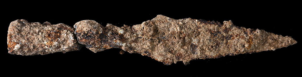
. A spearhead from the battle against Titus’ army. Photographic credit: Clara Amit, courtesy of the Israel Antiquities Authority.
— ” —
Christians see the A.D. 70 destruction of Jerusalem as a fulfillment of the prophecy of Jesus.
“But when you see Jerusalem surrounded by armies, then know that its desolation has come near.” (Luke 21:20 ESV; see also Matthew 24 and Mark 13)
Some of the photos can be enlarged by clicking on the image.
A reader sent an Email complimenting the blog and asking for help in answering a question.
“When lot and Abraham parted, lot went down to the dead Sea, while Abraham went up to Hebron. Do you know why he went to Hebron? It seems like such a key question I ought to know the answer to, but [so] far it has evaded me!”
Not sure that I will be able to satisfy the curiosity of the reader, but perhaps these comments will help.
Let’s begin with a survey of Abraham’s early time in the land of Canaan. (All of the references are to the book of Genesis unless otherwise indicated.) I suggest that you follow along in your Bible atlas.
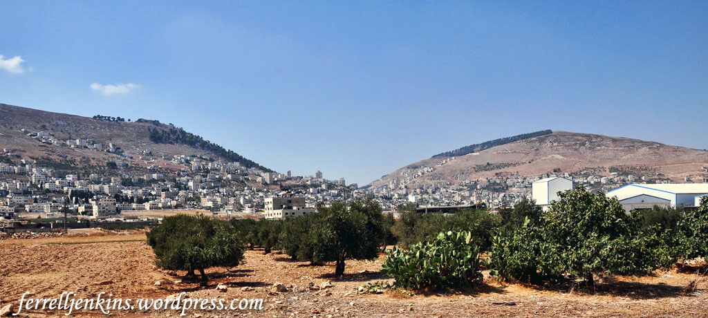
View west to the Shechem valley between Mount Gerizim (left) and Mount Ebal (right). Photo by Ferrell Jenkins.
First stop at Shechem (Genesis 12:6).
Later he settled between Bethel and Ai (12:8).
Took a trip to Egypt and then returned to the Negev before going back between Bethel and Ai (12:10; 13:1, 3). There was not available land to accommodate the herds of both Abraham and Lot (13:6).
Important fact. The Canaanite and Perizites were in the land. Abraham and Lot were strangers and had to move to empty spaces, or perhaps negotiate grazing rights. Lot chose to go to the well-watered Jordan Valley as far as Sodom (13:10).
The LORD spoke to Abraham. “The LORD said to Abram, after Lot had separated from him, ‘Lift up your eyes and look from the place where you are, northward and southward and eastward and westward, for all the land that you see I will give to you and to your offspring forever. I will make your offspring as the dust of the earth, so that if one can count the dust of the earth, your offspring also can be counted'” (13:14-16 ESV).
The LORD instructed Abraham: “Arise, walk through the length and the breadth of the land, for I will give it to you.” (13:17 ESV).
“So Abram moved his tent and came and settled by the oaks of Mamre, which are at Hebron, and there he built an altar to the LORD” (13:18 ESV).
Abram later rescued Lot at Dan, and continued to chase the eastern armies north of Damascus (14:14).
A statement of the extent of the promised land is given in 15:18.
Abram later lived in Beersheba (21:31).
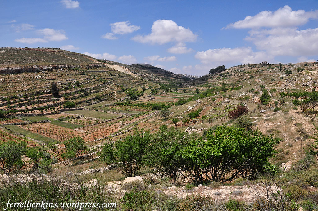
A beautiful, fertile valley along the central mountain range between Bethlehem and Hebron. Photo by Ferrell Jenkins.
Answer. The trip to Hebron was simply part of the overall plan to walk the land that the LORD was to give to Abraham’s descendants.
It is important to notice that the Canaanite towns visited by Abraham lie along the central mountain range. Rasmussen identifies this range,
The second major longitudinal zone is the central mountain range, which runs from Galilee in the north to the Negev Highlands in the south. (Rasmussen, Carl G. Zondervan Atlas of the Bible. Rev. Ed. Grand Rapids, MI: Zondervan, 2010. Print.)
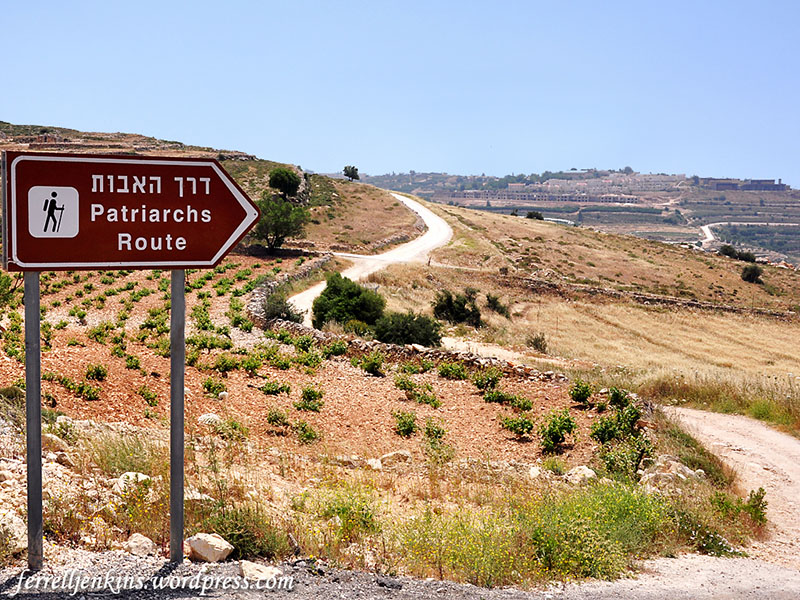
The central mountain range is sometimes identified today as the Patriarchs Way or Route.
Patriarchs Route between Bethlehem and Hebron. Photo by Ferrell Jenkins.
From time to time I have cited The IVP Bible Background Commentary: Old Testament because it provides succinct comments related to the cultural background of biblical events.
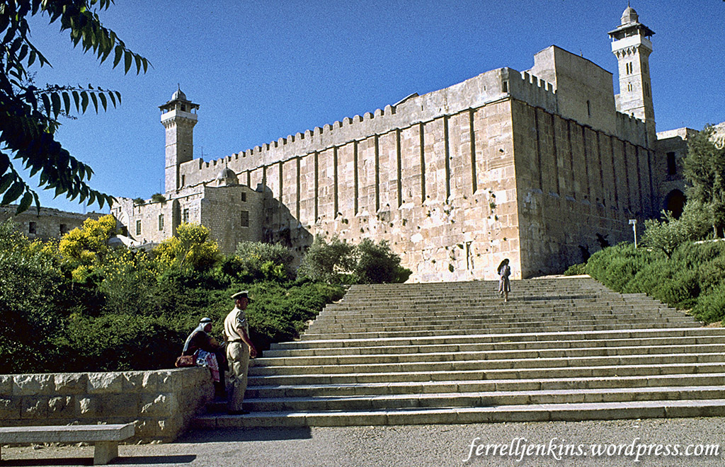
The city of Hebron is located in the Judean hill country (c. 3,300 feet above sea level) approximately nineteen miles southeast of Jerusalem and twenty-three miles east of Beersheba. Ancient roadways converge on this site coming east from Lachish and connecting with the road north to Jerusalem, indicating its importance and continuous settlement. Its springs and wells provide ample water for olive and grape production and would have supported a mixed agricultural-pastoral economy such as that described in Genesis 23. Hebron is said to have been founded “seven years before Zoan” (Avaris in Egypt), dating it to the seventeenth century B.C. (see comment on Num 13:22). The construction of an altar here, as at Bethel, transforms this into an important religious site, and its subsequent use as a burial place for the ancestors established its political importance (reflected in the Davidic narrative—2 Sam 2:1–7; 15:7–12). (Matthews, Victor Harold, Mark W. Chavalas, and John H. Walton. The IVP Bible Background Commentary: Old Testament. electronic ed. Downers Grove, IL: InterVarsity Press, 2000. Print.)
The cave of Machpelah, burial place of Abraham and Sarah, and others from the patriarchal period. Photo by Ferrell Jenkins.
Understanding the land helps one better understand the biblical text.
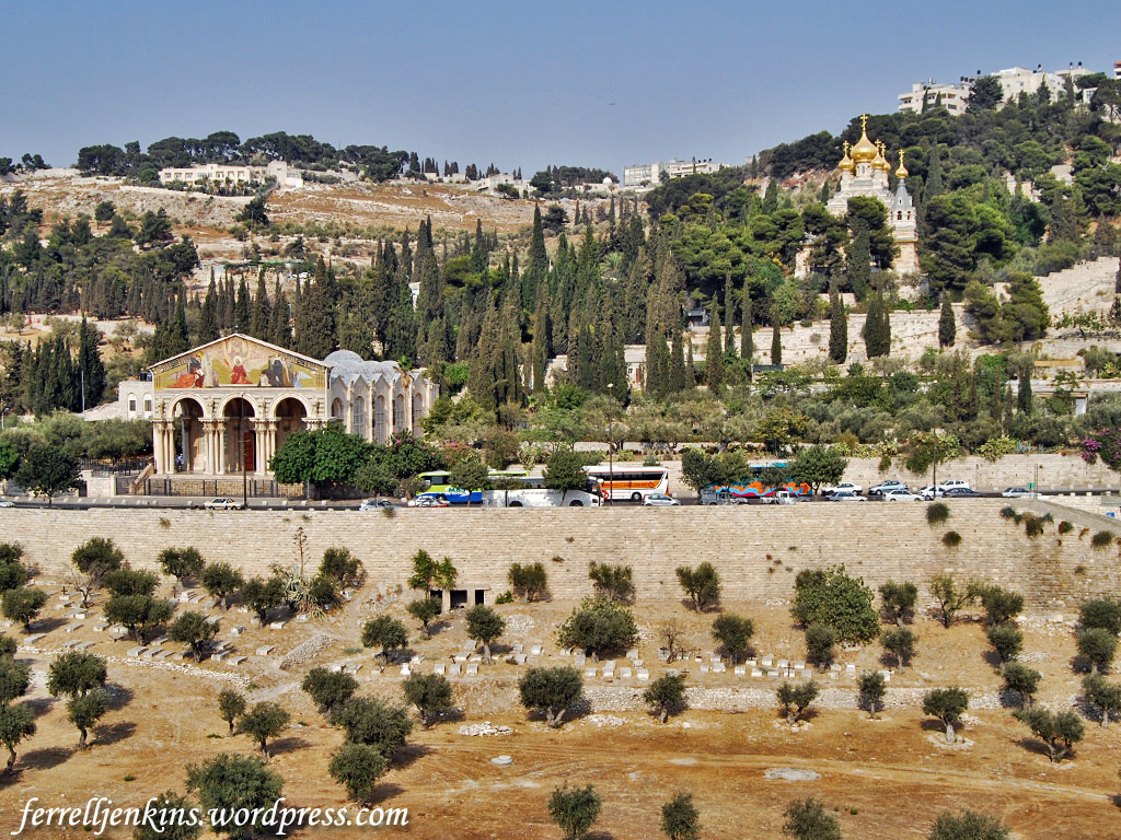
Frequently over the years I have had tour members ask me, “What is that building?” as they pointed to the building with golden onion tops. The simple answer is that this is the Russian Garden of Gethsemane. More specifically, the building is known as the Church of St. Mary Magdalene.
The Church of All Nations (left) and the Church of St. Mary Magdalene on the Mount of Olives. Photo by Ferrell Jenkins.
Many will recognize the Church of All Nations and its’ Garden of Gethsemane. Murphy-O’Connor says,
No one can be sure of the exact spot at which he prayed, but this limited area was certainly close to the natural route leading from the Temple to the summit of the Mount of Olives and the ridge leading to Bethany. (The Holy Land, 5th ed., p. 147).
The New Testament account explains that the disciples of Jesus went with him to the Mount of Olives (Matthew 26:30), to a placed called Gethsemane.
Then Jesus went with them to a place called Gethsemane, and he said to his disciples, “Sit here, while I go over there and pray.” (Matthew 26:36 ESV)
The Church of St. Mary Magdalene has received quite a bit of attention in the Israeli newspapers because Prince Charles, Prince of Wales, went there after attending the funeral of former Israeli President Shimon Peres. The paternal grandmother of Prince Charles, Princess Alice of Battenberg, died in 1969 but was transferred to the Mount of Olives according to her request in 1988. The Times of Israel explains,
Alice of Battenberg was recognized by Israel’s Yad Vashem Holocaust Memorial as a “Righteous Among the Nations” and by the British government as a “Hero of the Holocaust.”
Prince Phillip is said to have visited the Church in 1994.
Princess Andrew of Greece (Princess Alice of Battenberg), mother of the Duke of Edinburgh visited the church and stayed in the monastery in the 1930s. Her wish was to be buried near her Aunt ‘Ella’, the Grand-Duchess Elizabeth whose devotion to the church and to nursing and charitable service she strove to emulate. Princess Andrew died at Buckingham Palace in 1969. Her wish to be buried at the Convent of Saint Mary Magdalene in Gethsemane was finally realized in 1988 when her remains were transferred to her final resting place in a crypt below the church.
The church stands in the Garden of Gethsemane, the place where Jesus spent His last night on earth. Also found on the convent grounds are the remnants of a pre-Roman road, the biblical entry to Jerusalem. Not far from this road is a large stone on to which the Mother of God dropped her cincture to Apostle Thomas on the third day following her Dormition.
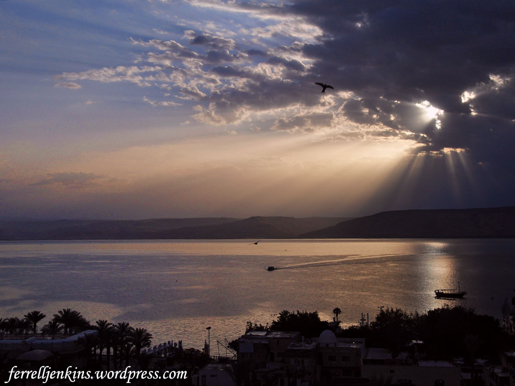
In looking through some photos from 2011, I noticed that the photos I made one morning were different from most sunrise photos I have taken. I thought some readers might enjoy seeing this. Click on the image for a larger photo.
Sunrise on the Sea of Galilee in 2011. Photo by Ferrell Jenkins.
We know that Jesus utilized the evening cool and the early morning in His ministry.
32 That evening at sundown they brought to him all who were sick or oppressed by demons.
33 And the whole city was gathered together at the door.
34 And he healed many who were sick with various diseases, and cast out many demons. And he would not permit the demons to speak, because they knew him.
35 And rising very early in the morning, while it was still dark, he departed and went out to a desolate place, and there he prayed. (Mark 1:32-35 ESV)
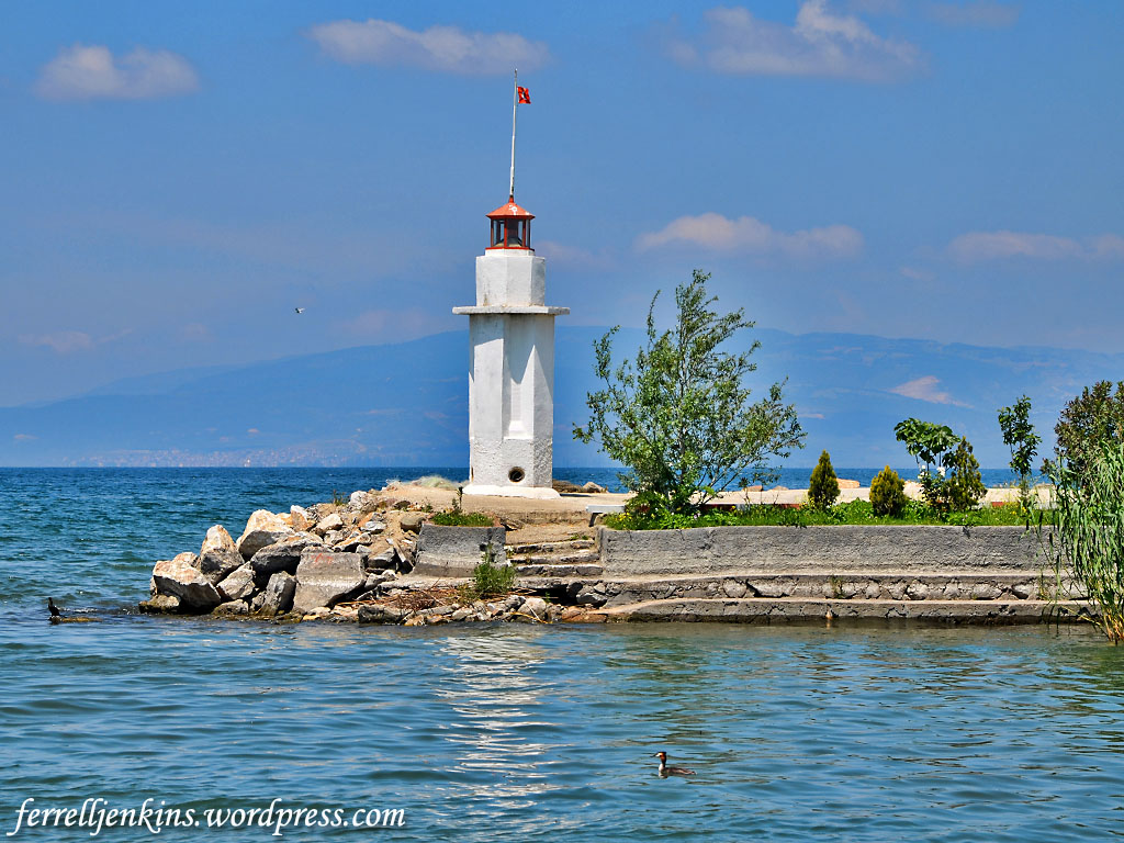
In an earlier article we posted photos of Lake Ascania (Iznik Gölü) at the place where the first Ecumenical Council met. Nearby there is a beautiful view of a small lighthouse with the mountains of Bithynia in the distance.
Lighthouse in Lake Ascania at Iznik. Photo by Ferrell Jenkins.
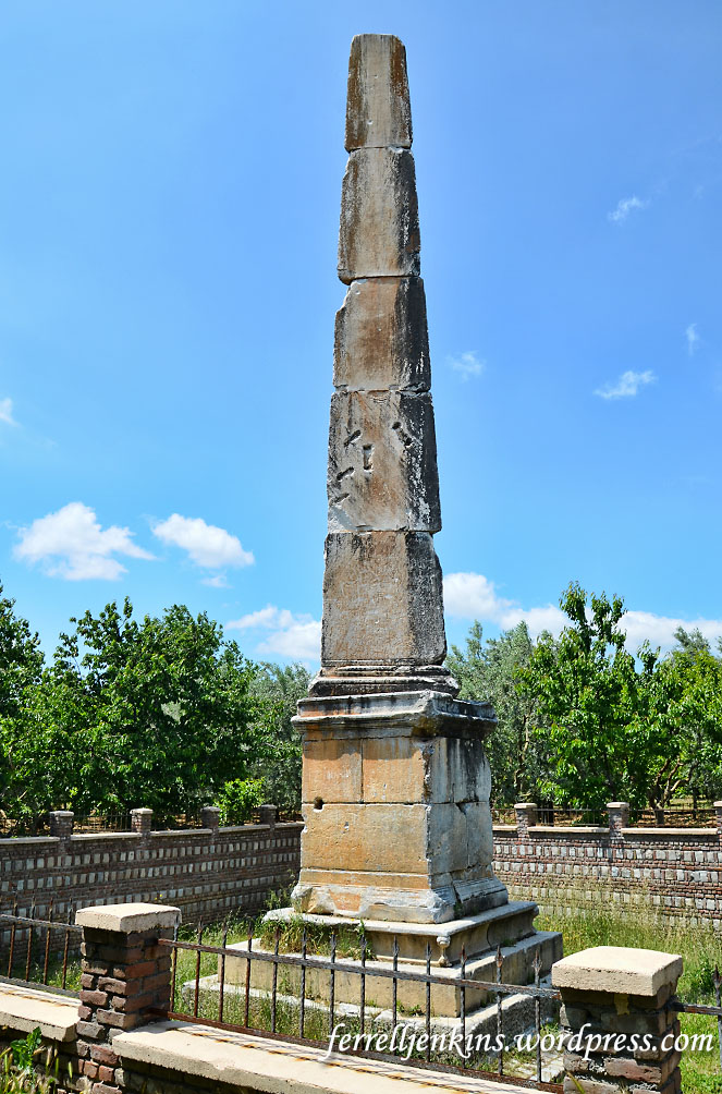
About 3 miles north of Iznik where the Roman road to Nicomedia once ran, in an orchard of olive and fruit trees, there is a stone obelisk from the early second century A.D. The Iznik promotional brochure says,
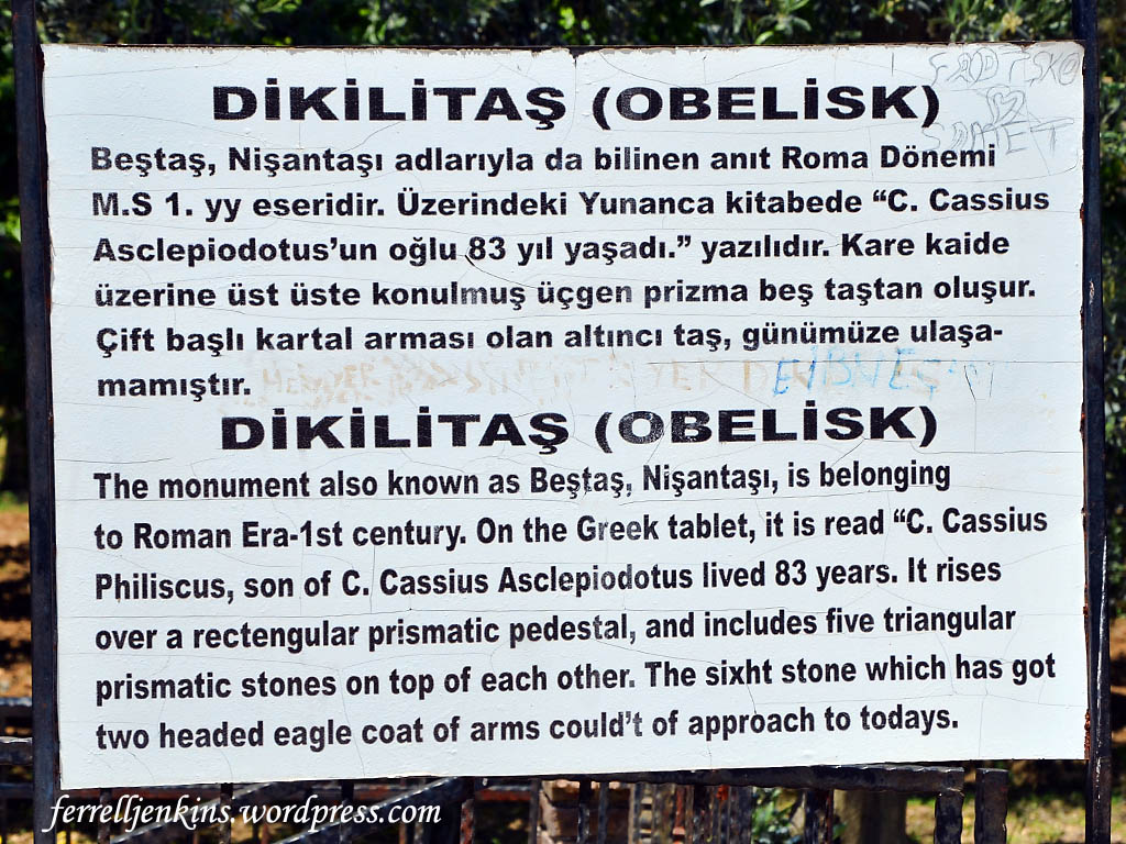
Its inscription in Greek reveals that the obelisk was built by C. Cassius Philiscus in the 1st century. It rises over a rectangular prismatic pedestal, and includes five triangular prismatic stones one over the other.
The inscription on the first of the triangular prismatic stones is in poor condition. The second stone indicates that something was once attached to the obelisk. Some suggest that it was a life-size human figure. Wilson says the obelisk is 39 feet tall.
The stone obelisk on the road from Nicea to Nicomedia. Photo by Ferrell Jenkins.
A sign at the site describes the monument in Turkish and English. I think you may agree with me that the last English sentence doesn’t make much sense.
The sign identifying the obelisk from the Roman period. Photo by Ferrell Jenkins.
Before closing this series I think a few words on the historical background of Iznik/Nicea are appropriate. We have frequently recommended Biblical Turkey by Mark Wilson as an excellent source for those who travel to Turkey. The following points are summarized from the second edition (pp. 371-2).
Antigonus founded the Hellenistic city of Antigonia here in 316 B.C.
Lysimachus captured the city in 301 B.C. and re-founded it, naming it after his first wife Nicea.
During the Roman period the city vied with Nicomedia for the distinction of being the principal city of Bithynia.
Augustus authorized a sanctuary of Roma and the deified Julius Caesar to be built at Nicea.
The bust of Lysimachus was photographed in the Ephesus Museum at Selçuk, Turkey, in 2008.
Bust of Lysimachus displayed in Ephesus Museum, Selcuk, Turkey.
Wilson is emphatic that Nicea would have been on the route of the messenger carrying the epistle of 1 Peter.
This is the final article in the series on Iznik/Nicea. Hopefully there will be some who will find it useful in the months to come. I think all of the photos are large enough for use in PowerPoint class presentations.
The museum of Iznik is noted for its collection of Blue Tiles for which the city is famous. In 2014 I found many of the museums in Turkey, or certain exhibits, closed for remodeling. Even with a polite request we were not allowed to visit the various monuments displayed in the yard of the museum.
The museum of Iznik was closed for remodeling in 2014. Photo by Ferrell Jenkins.
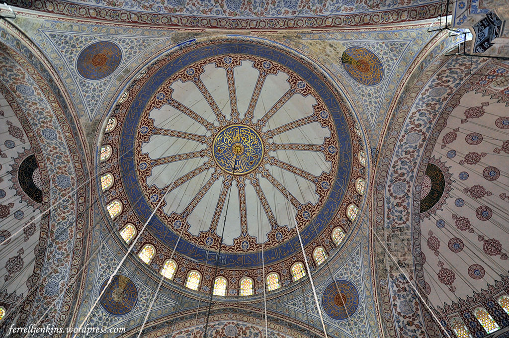
Missing the tile work for which the city is famous was not a great loss. Tile work from Iznik may be seen in the ceiling of the Blue Mosque, in the Topkapi Palace, and other buildings in Istanbul.
The ceiling of the Blue Mosque is a good example of the Iznik tile. Photo by F. Jenkins.
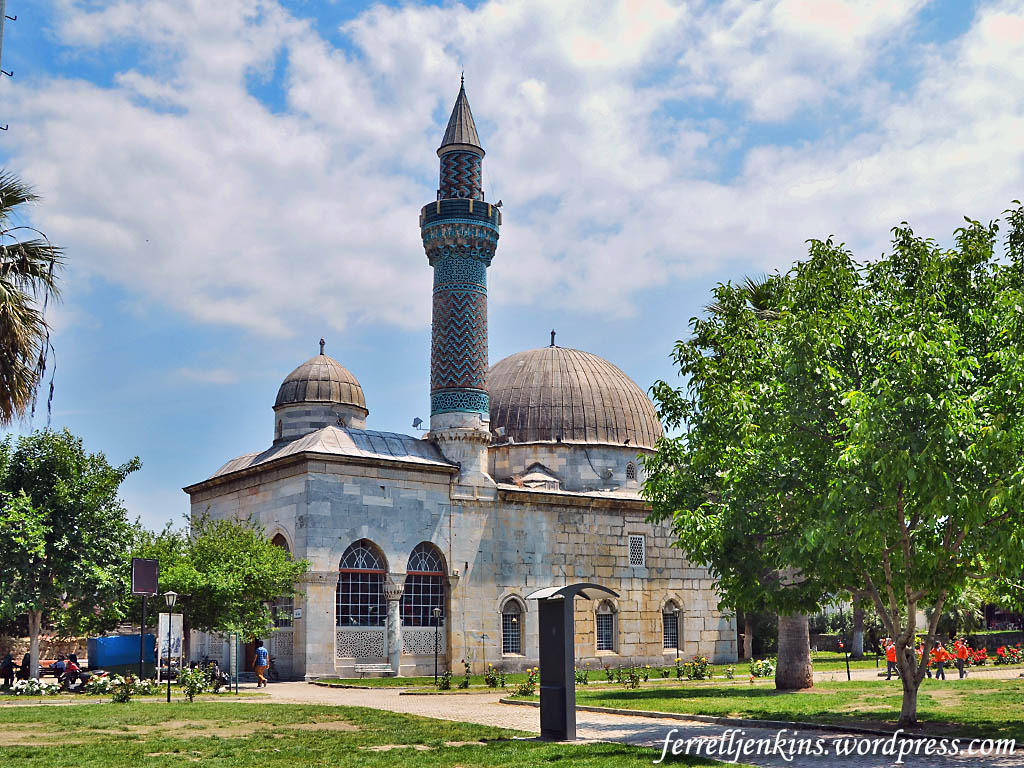
One expects to see mosques in any Turkish city. I am including this photo of the Yeşil (Green) Mosque. The promotional tourism information includes this information about the mosque.
Recognised as the symbol of İznik, the Yeşil Mosque takes its name from the turquoise coloured İznik tiles and bricks of its minaret which are a fine reflection
of Seljuk minaret style in Ottoman art. Built by the architect Hacı Musa between 1378 and 1392 upon the request of Halil Hayrettin Pasha, this mosque is
undoubtedly the most magnificent of the single domed mosques of the Ottoman Period. Its unique minaret is on the right corner of the mosque. While its niche displays rich stone work, its body is covered with blue and green coloured tiles in zigzag mosaic style.
The Green Mosque in Iznik. Photo by Ferrell Jenkins.
The Biblical Connection
The events we have described in this series on Iznik/Nicea are post apostolic, but the general area does have two connections to the New Testament.
On the outbound portion of Paul’s third journey he attempted to go into Bithynia, but was not permitted to do so.
And when they had come up to Mysia, they attempted to go into Bithynia, but the Spirit of Jesus did not allow them. (Acts 16:7 ESV)
We have already pointed out that the epistles of Peter were written to saints in various Roman provinces including Bithynia.
Peter, an apostle of Jesus Christ, To those who are elect exiles of the Dispersion in Pontus, Galatia, Cappadocia, Asia, and Bithynia, (1 Peter 1:1 ESV)
I plan to show you one more famous landmark on the outskirts of Iznik as the eighth in this series.
Nicea, now identified with Iznik, Turkey, was in the Roman province of Bythinia in Asia. A Roman lawyer named Pliny served as governor of Bithynia and Pontus (A.D. 111-113) and exchanged a series of letters with the Roman Emperor Trajan (A.D. 98-117).
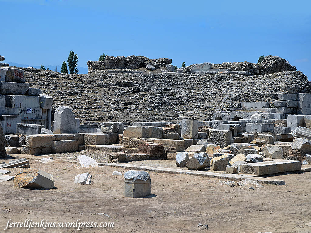
The theater at Nicea was constructed while Pliny was governor of Bithynia. According to the tourism publication on Iznik the theater,
… was converted into a mass graveyard in the 13th century. The graveyard was later replaced by the ceramic kilns. Only some part of the cavea (audience section) of the ancient theatre have survived to the present day. It appears that its stones were used as construction materials especially in the restoration of the city walls.
The theater is estimated to have seated 15,000 persons.
Ruins of the theater dating to the reign of the Emperor Trajan. Photo by Ferrell Jenkins.
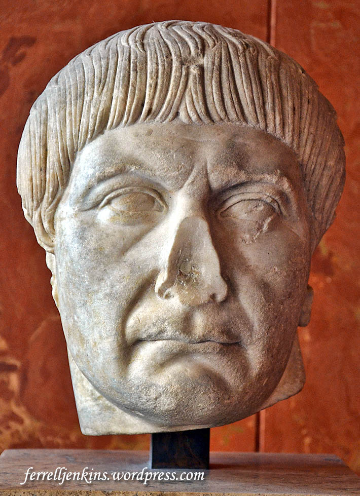
From the letters exchanged between Pliny and the Emperor Trajan we know that Christians were persecuted during his reign. (For more information see our post here.)
Emperor Trajan (A.D. 97-117). Louvre. Photo by Ferrell Jenkins.
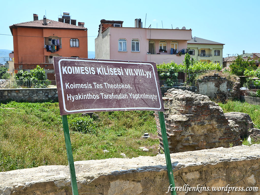
There are ruins of a few churches (meaning “meeting places”) in Iznik. No doubt many ruins are under the buildings of the modern city, but the area pictured below marks the site of the Dormitian of the Mother of God (Theotokos = God-bearer). At the Council of Ephesus in A.D. 431 “Theotokos was approved as a right title for the Virgin Mary” (Peter Toon, The New International Dictionary of the Christian Church, p. 344). Sources such as Philip Schaff provide much more detailed information for those interested.
Sign at site of Dormitian of the Theotokos, built by Hyakinthos. Photo by Ferrell Jenkins.
If you have traveled much in the Middle East you have likely seen several sites associated with the dormitian of Mary, the place where she went to sleep before being assumed into heaven, according to Catholic and Orthodox theology. Our guide for the day to Nicea/Iznik waits for us to make our photo before entering the few remaining ruins of the church.
Guide waiting to take us into ruins of the Dormitian church. Photo by Ferrell Jenkins.
This church was built by Bishop Hyakinthos in the 7th or 8th century. Only with flash and some work in Photoshop was I able to show this much of the structure. The Blue Guide Turkey “The Lascarid emperor, Theodore 1 (1204-22) was buried here.”
Dark remains of the Dormitian church of the Theotokos. Photo by Ferrell Jenkins.
In Part 7 we will move to a few of the modern buildings of Iznik.


You must be logged in to post a comment.