Category Archives: Bible Study

Enjoying the local customs

One of the joys of travel is learning about the customs of the local people. Of course, I have a special interest in finding customs that remind us of customs in Bible times. In many places the local entrepreneurs realize that tourist enjoy this so they make it possible for you to see and participate in the customs. This woman at a restaurant near Memphis, Egypt, is baking bread as it has been done for centuries in Egypt. Yes, the bread was delicious.

Perhaps you can recall the episode in Genesis 40 about “the cupbearer and the baker for the king of Egypt.”

Sunset at Lachish

This photo was made from inside the gate at Lachish looking west toward the Mediterranean Sea. The city faced two significant sunsets. It fell to the Babylonians in 587 B.C. The Lachish Letters were found immediately outside this gate in a room on the left. My friend and colleague, the late Phil Roberts, worked in the gate when we were at Lachish in 1980. Phil continued to work there each year until the excavation came to a close. When the prophet Jeremiah wrote, only Lachish and Azekah remained of the fortified cities of Judah (Jeremiah 34:7).

Lachish fell to the Assyrians more than a hundred years earlier in 701 B.C.The Bible records the events after the fall of Samaria this way,

Now in the fourteenth year of King Hezekiah, Sennacherib king of Assyria came up against all the fortified cities of Judah and seized them. Then Hezekiah king of Judah sent to the king of Assyria at Lachish, saying, “I have done wrong. Withdraw from me; whatever you impose on me I will bear.” So the king of Assyria required of Hezekiah king of Judah three hundred talents of silver and thirty talents of gold. Hezekiah gave him all the silver which was found in the house of the LORD, and in the treasuries of the king’s house. At that time Hezekiah cut off the gold from the doors of the temple of the LORD, and from the doorposts which Hezekiah king of Judah had overlaid, and gave it to the king of Assyria. Then the king of Assyria sent Tartan and Rab-saris and Rabshakeh from Lachish to King Hezekiah with a large army to Jerusalem. So they went up and came to Jerusalem. And when they went up, they came and stood by the conduit of the upper pool, which is on the highway of the fuller’s field. (2 Kings 18:13-17)

Sennacherib was unable to capture Jerusalem. I take it that the destruction of Lachish was his greatest achievement because he plastered the walls of his palace in Nineveh. This photo shows the king receiving the surrender of Lachish.

The cuneiform inscription reads as follows:

Sennacherib, king of the world, king of Assyria, sat upon a (nîmedu) -throne and passed in review the booty (taken) from Lachish (La-ki-su). (ANET 288).

Lachish on July 4th

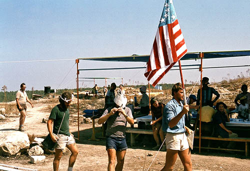
On July 4, 1980, I was participating in the excavation at Tel Lachish in Israel along with three of my colleagues from Florida College (James Hodges, Phil Roberts, and Harold Tabor). There were sizable numbers of participants from Israel, United States, Australia, South Africa, and Germany. In addition to the hard work out in the sun, we had some fun. On the morning of July 4th a few of the guys got an American flag and put together a drum and bugle corp and marched across the tel. Note especially the plastic bucket being used as a drum in this photo.

Lachish is identified with Tell ed-Duweir, located in the shephelah (lowlands) of Judah about 30 miles south west of Jerusalem. It is mentioned in Scripture during the period of the conquest (Joshua 10, 12, 15). Lachish served as one of the Judean store cities during the period of the kingdom Judah. Many of the LMLK jar handles have been found here. The city fell both to the Assyrians and the Babylonians.

Excavations were carried out by the British between 1932 and 1938 under the direction of J. L. Starkey. Starkey was murdered in 1938 while en route to the opening of the Palestine Archaeological Museum (later the Rockefeller Museum) in Jerusalem. Professor Yohanan Aharoni of Tel Aviv University excavated the “Solar Shrine” in 1966 and 1968. A new excavation was begun in 1973 under the auspices of The Institute of Archaeology of Tel Aviv University and The Israel Exploration Society. Dr. David Ussishkin served as the director until 1994.

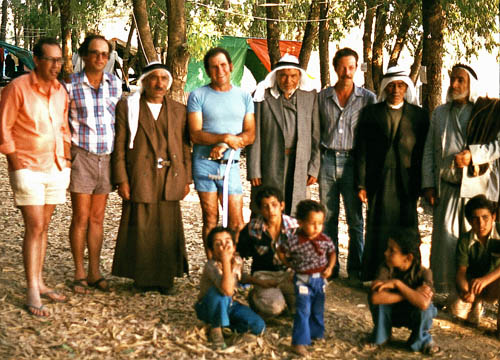
One afternoon while we were in our tented camp a short distance from the tel, a bus load of Arabs from Jordan arrived. They had once lived in the area, prior to the founding of the State of Israel. Some of the older men had worked with Starkey. This photo which I took shows four of the Arab men and three of the Israeli archaeologists, along with one American. See if you recognize Gabriel Barkay, Richard Whitaker, Adam Zertal, and David Ussishkin.

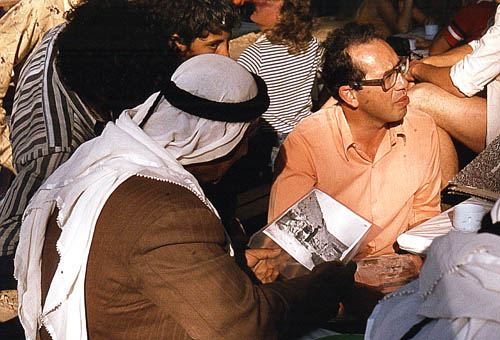
The Arab men enjoyed seeing the old photos from the Starkey excavations and pointing out themselves as much younger men. I think you will see Ussishkin’s head to the left of the Arab, and Barkay on the right.

I thought you might enjoy this little bit of recent history from 28 years ago.

Update (July 6, 2008). Todd Bolen, at BiblePlaces.com has commented on this blog under the title Reminiscences of Lachish. He says he heard Gabriel Barkay tell about this event, but he includes some additional information that I did not know, including the name of the village where the Arabs previously lived.

The town of Qubeibe was leveled by the Israeli military in the 1960s and the stones of the village, probably many taken from the ruins of Lachish, were sold to building contractors.  Who knows but some ancient inscription was unknowing transferred from Lachish to Qubeibe and is now part of a wall in the area?

I recall that Richard Whitaker was the one best able to converse in Arabic.

Assos temple to be restored

The current issue of Artifax reports that the temple of Athena at Assos in northwestern Turkey is to be restored. The temple was built originally about 540-530 BC. The project is expected to take about three years. Many pieces of the temple are scattered in museums (Istanbul Archaeological Museum, Louvre, Boston Museum of Fine Arts). The temple is built on a high cliff overlooking the sea. Here is the way the temple looks now.

The apostle Paul undoubtedly saw the temple of Apollo when he traveled the approximate 20 miles from Alexandria Troas to Assos by land. His companions had traveled by boat from Troas to Assos. The historical account reads this way:

But going ahead to the ship, we set sail for Assos, intending to take Paul aboard there, for so he had arranged, intending himself to go by land. And when he met us at Assos, we took him on board and went to Mitylene. (Acts 20:13-14 ESV)

The island across the strait is Lesbos. Further south is the town of Mitylene on Lesbos. Lesbos is now a Greek island in the Aegean.

Sunset over Edom

I ran across this beautiful sunset photo that I made from a hotel above Petra, Jordan, in 2006.

The oracle concerning Edom. One keeps calling to me from Seir, “Watchman, how far gone is the night? Watchman, how far gone is the night?” The watchman says, “Morning comes but also night. If you would inquire, inquire; Come back again.” (Isaiah 21:11-12)

There are some text critical issues with the term Edom in this verse, but I will leave that for you to work on. Keil and Delitzsch call attention to a comment by Luther that illustrates the certain judgment that would come upon ancient Edom, the descendants of Esau.

But what is the meaning? Luther seems to me to have hit upon it: “When the morning comes, it will still be night.”

The decline and fall of any nation ought to cause one to take a pause and think about it.

The Fascination of Egypt

Egypt has a grip on the imagination of each of us. We probably first learned something about it in our elementary school studies. We have seen it portrayed in movies and television programs.

Every Bible student has studied about Egypt in numerous contexts. Not only did the tribes of Israel grow into a nation while in Egyptian bondage, but we know of the following characters who visited Egypt: Abraham, Jacob, Joseph, Moses, Joshua, Jeremiah, Jesus, Mary and Joseph. The prophets spoke much about the land of Egypt. Egypt is mentioned more than 600 times in the Bible.

This is a panoramic photo I made of the Pyramids of Giza in 2005. The pyramids, from left to right, are Mycerinus, Chephren, and Cheops. These structures were built about 2500 B.C. Some people have the mistaken idea that the Israelites in Egyptian bondage built the pyramids. You can see from the date that these pyramids were built about 1000 years before the Israelites did their building (Exodus 1:11).

LMLK jar handles

During the time of the Divided Kingdom, pottery jars with handles bearing the Hebrew letters LMLK seem to have been in common use. T. C. Mitchell comments briefly on these handles:

These handles of pottery jars which had been stamped before baking, with seals show symbols, either a four-winged scarab or a two-winged disc, with lmlk, ‘belonging to the king’ written above it in Hebrew script and a place-name below it. Over eight hundred of these stamped handles have been found at over twenty excavated sites in Palestine, nearly all in the territory to which Judah was confined by about 700 BC. (The Bible in the British Museum, page 55).

Tourists who have an interest in archaeology often pick up shards of pottery as they walk across various tells. It is not uncommon to locate a jar handle or the rim of a bowl. Recently a college student found a LMLK handle at Ramat Rahel, a site between Jerusalem and Bethlehem. Several blogs have commented on it. Todd Bolen has a nice photo of the handle here. A newspaper article about the chance find is here.The LMLK web site has a report here.

This is a photo of a LMLK jar handle that I made in the British Museum. The handle was found at Lachish. The LMLK handles have the phrase LMLK (“belonging to the king”) and the name of one of the cities that served as a distribution center: HBRN (Hebron), ZP (Ziph), SWKH (Socoh), or MMST. This one has SWKH.

King Hezekiah built “storehouses…for the produce of grain, wine and oil” (2 Chronicles 32:28). Mitchell says that the LMLK vessels “would have been suitable for any of the three staples derived from the land, grain, wine or oil.”

A New, Smaller Bible Atlas

Carta's New Century Handbook and Atlas of the Bible

Carta’s New Century Handbook and Atlas of the Bible
Abridgment of The Sacred Bridge

by Anson F. Rainey and R. Steven Notley
Carta, Jerusalem, 2007
280 pages + full color illustrations and maps, English. Cloth, 9 x 12 inches
ISBN: 9789652207036
List Price: $50.00. Your Price: $45.00

Several times we have mentioned the important of the Bible student having a good atlas. Check here. Two years ago Carta brought out The Sacred Bridge, by Rainey and Notley. The book is large, and the content is more than most students want or need. And the price was $100. In response to a request from many professors, the same authors have prepared Carta’s New Century Handbook and Atlas of the Bible. I have not seen this book, but I have been using the larger atlas, and I plan to get a copy of the abridged edition. Fortunately I was able to get The Sacred Bridge autographed by Rainey and Notley.

Eisenbrauns is the US distributor of Carta books and maps. A click on the title at the top will take you to their web page.

Ramoth in Gilead

Ramoth in Gilead (or Ramoth-gilead) was a town in Gilead that was included in the territory of the Israelite tribe of Gad in Transjordan (Joshua 20:8). It was one of the Levitical cities of refuge for the Israelites (Joshua 21:38). The most memorable associated with Ramoth-gilead recorded in the Bible is the battle with Aram (Syria) in which Ahab was killed (1 Kings 22). Elijah sent one of the sons of the prophets to Ramoth-gilead to anoint Jehu as king of Israel (2 Kings 9:1).

The identity of Ramoth-gilead is uncertain. Two sites are frequently mentioned by scholars: Tall ar-Rumeith and Ar-Ramtha.

Burton MacDonald, in East of the Jordan, says,

There is also archaeological support for choosing Tall ar-Rumeith, situated in the fertile plain area just to the southeast of the junction of the ‘Amman-Damascus and Irbid-Mafraq highways, as the location for Ramothgilead. (page 200)

Paul Lapp excavated at Tall ar-Rumeith in 1967. Little archaeological work has been done at Ar-Ramtha. I have not gone into the Jordanian city of Ramtha, but understand that the mound is covered by the town, thus making it difficult to conduct an excavation.

Here is a photo I made at Tall ar-Rumeith in 2002. It is not surprising to see camels here because the desert is near (to the east). From the top of the tell there is a great view looking north across a fertile plain to the border with Syria.

Earlier this year I went back to the site, but found that some modern housing has been built adjacent to the east side of the tell. It appears to be serving as housing for Indian students. I speculate that they attend a nearby university.

This photo shows a modern trench made to make a road to part of the construction site.

We found some pottery in the road, but can not be certain that it came from the damage to the tell. I did not see any shards along the edge of the cut.

This illustrates a real problem associated with ancient sites in isolated places. In a place like Jordan there are so many sites that it is impossible to excavate, preserve, and guard all of them.

A note on spelling. You may note different spellings of the word describing an archaeological mound. In Israel the term Tel is used. Earlier the term Tell was used throughout the Middle East. In Jordan the term Tall has come into common use.

There is also much variation in the spelling of some of the compound biblical names in scholarly sources, and even in English translation of the Bible. This is illustrated in this post and the previous one on Bethshan.

Bethshan – Bet She’an

Bethshan is mentioned only a few times in the Old Testament. The New American Standard Bible uses the following spellings for this town: Beth-shean; Beth-shan; Bethshan. Today the modern town and ancient site go by the name Bet-She’an. The site was important because of its location at a major junction of two valleys, the Jordan valley with the Jezreel valley. The tell, called Tell el-Husn or Tel Bet She’an, commands an impressive view of the area, including a great view of the land of Gilead.

Today I am preparing a class dealing with the account of the eastern tribes building an altar “in the region of the Jordan which is in the land of Canaan” (Joshua 22:10). While looking for some photos to illustrate this episode in the history of Israel I thought of the view from the tell of Bethshan. We do not know the exact location, but this view provides a wonderful view of the land of Gilead (now in Jordan) which was given to Gad and Manasseh. You will observe trees below the tell. This is the where the River Harod flows, continuing down to the Jordan. You will notice ruins of a bridge that once crossed the river.