
Leaving Bethany Beyond the Jordan in the Jordan Valley we drove northeast on highway 437 toward Salt. We wanted to bypass Amman on our way to Jerash, the second largest city of the Decapolis after Damascus. This road took us through Wadi Shu’ayb.
Does Wadi Shu’ayb have anything to do with the Bible? Maybe so.
Shu’ayb is the Arabic name for Jethro, the father-in-law of Moses (Exodus 3:1). It you have traveled around the Sea of Galilee in Israel you have doubtless seen the Horns of Hattin. You can see our photo-filled post about it here. Below Hattin, on the edge of the Arbel Pass, there is a building believed by the Druze to be the burial site of Nebi Shu’ayb (or Shu’eib). The Druze gather at the site every spring for a festival.
Back to Jordan and the Wadi Shu’ayb or Valley of Jethro. The Moslem belief in the area is that Shu’ayb (or Jethro) is buried here. I have observed that it is not uncommon in the Moslem world to find multiple burial sites for various Old Testament greats. Our aim was to get to Jerash in time for the morning Roman Army and Chariot Experience so we only took time to make a few photos in the valley.
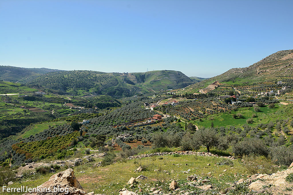
The first photo looks back toward the Jordan Valley. It is interesting to note the barrenness on the west side of the valley and the vegetation on the east side. I have read in a few sources that the water runs perpetually, but I don’t think that is the case now. I enlarged some of the original photos and found places where the stream bed is dry. There were some dark areas where I can not rule out a few pools of water. In many cases the water that once flowed in these streams is now diverted for use by the burgeoning population for their agriculture.

A view of Wadi Shu’ayb looking toward the Jordan Valley.
Photo by Ferrell Jenkins.
As we continued to drive northeasterly we stopped for another photo of the hillsides with nice houses and orchards.
Continuing in Wadi Shu’ayb we saw nice houses and orchards.
Photo by Ferrell Jenkins.
Is the legend about Jethro the only connection between Wadi Shu’ayb and the Bible? Definitely not.
Two sources that I have enjoyed studying in preparation for this post remind us that Jazer was one of the towns allotted to the Gaddites, and associated with the territory of Gilead. Burton MacDonald finds the site of Jazer, one of the Levitical cities, in this area.
Jazer (Num 21.32; 32.3, 35; Josh 13.25; 21.39; 2 Sam 24.5; 1 Chr 6.81; 26.31; Isa 16.8, 9; Jer 48.32; 1 Macc 5.8): According to Num 21.32, Jazer was a possession of the Amorites that the Israelites captured, while Num 32.3 identifies it as a place the Reubenites and Gadites desired. Jazer was among the towns that Moses is said to have allotted to the Gadites, who rebuilt it (Num 32.35). It is listed as Gadite territory (Josh 13.25) and as a Levitical city (Josh 21.39; 1 Chr 6.81); and it is cited as one of the
places where Joab took the census in Transjordan (2 Sam 24.5). David found men of great ability in Jazer in Gilead (1 Chr 26.31), thus associating the site with the district of Gilead (see Chapter 10). Jazer appears in the oracles of both Isaiah (16.8, 9) and Jeremiah (48.32) against Moab, and so it would appear to be a Moabite possession. Finally, Judas Maccabeus is said to have crossed the Jordan and taken Jazer and its villages (1 Macc 5.8). (“East of the Jordan,” p. 106)
MacDonald concludes,
Based on the available evidence, there seems to be little doubt that Khirbat Jazzir is the best candidate for the site of biblical Jazer. It matches the biblical and extra-biblical literary information, it is toponymically viable, and there is archaeological evidence of settlement during the Iron Age. (108).
David Z. Moster, in a 2017 Ph.D. Thesis at Bar-Illan University, discusses Wadi Shu’ayb as it relates to the land of Gilead. He thinks that the land of Gilead was divided so that we may think of the two “halves” of Gilead, something already mentioned by Moses in Deuteronomy 3:12-13, and Joshua 12:2, 5; 13:31. The two “halves” are divided along the Jabbok River (Joshua 12:2).
The northern portion roughly corresponds to what is today called the Ajloun (Arab. عجلون ) and the southern portion roughly corresponds to what is today called the Balqa (Arab. البلقاء ). There were two “lands” within this general territory that were not considered Gilead proper, namely the land of Jazer (Num 32:1; Josh 13:25; cf. 1 Chr 26:31), which was probably located along Wadi Shu’ayb until es-Salt (perhaps at Khirbet Jazzir), and the land of Ammon (e.g., Deut 3:16; Josh 12:2; 13:25; Judg 11:29), which was located along the Zarqa River until Ammon itself, contemporary Amman. (Moster, David Z. The Tribe of Manasseh and the Jordan River: Geography, Society, History, and Biblical Memory. Diss. Bar Illan U. 2017.) p. 169.
Traveling in the Bible lands and studying the geography of those lands provides the background for understanding what we read in the Bible. I trust that this little article will help you better understand this area when you read about it in the Bible.

Ferrell: Thanks for a very interesting post. Your explanation that the first photo is looking southwest makes perfect sense, and helps explain the contrasting slopes. It’s the same phenomenon one sees in the Judean Desert on the way down to the Dead Sea in the springtime: The north-facing slopes receive less direct sunlight and thus retain more of their winter moisture.
TOM POWERS / Waynesville, NC
John, that is an excellent point. I was thinking about a person who really wanted to see a place like this using a Jordanian road map with a guide book or such and looking at the Jordan Valley (Bethany Beyond the Jordan), and Salt, and highway 437. and being able to know the directions. The first photo looking toward the Jordan Valley would be southwesterly. The wadi bed is immediately below. In the second photo we are looking northeasterly, and the Wadi Shu’ayb is mostly behind us. The mountains we see here begin to be part of the Transjordanian plateau. Trust this will help a bit, and I will try to do better in the future. Thanks for following the blog.
Thank you for these posts – I really appreciate them. I do have a request: would you be willing, for someone like me who is a rookie at Holy Land geography, to state which direction you are facing when you post a picture? I can sometimes interpret it, like when you state there is vegetation on the east side of a valley, and it’s on the left of the picture, that I must be facing south, etc., but sometimes I fear I get turned around and I’m not really sure what direction I am facing. Thanks!