Category Archives: Jordan

Roman army photos

A large number of visitors to this blog have looked at the post on the Roman soldiers and chariot races at Jerash, Jordan. Photos of Roman soldiers can be helpful in illustrating Bible class lessons and sermons. Think of a few of the texts.

  • The Centurion at Capernaum (Matthew 8:5).
  • Cornelius, the first Gentile convert to Christ (Acts 10:1).
  • “Whoever forces you to go one mile, go with him two” (Matthew 5:41).
  • Soldiers who mocked Jesus (Luke 23:36).
  • Soldiers and centurions who rescued Paul from the mob (Acts 21:32).
  • Paul’s figurative reference to fellow-workers in the Kingdom as soldiers (2 Timothy 2:4; Philemon 1:2).
  • The praetorian guard (Philippians 1:13).
  • The full armor of God (Ephesians 6:10).

David Padfield has prepared 15 photos from the RACE (Roman Army and Chariot Experience) program at Jerash, Jordan, under the title Bible Times: Roman Army Enactment. All of these photos are prepared in 1024 x 768 size, suitable for PowerPoint presentations. Here is a small photo from the collection.

Roman Army in Battle Gear. Photo by David Padfield.

Roman Army in Battle Gear. Photo by David Padfield.

Take a look at all of the photos here. From this page you can locate other sets of photos that David has prepared for use in teaching the Word.

Where are the copper mines?

Eilat, on the north shore of the Gulf of Eilat (or Aqaba), has been our base for a couple of days. This area is significant in biblical history.

  • Israel camped at Ezion-geber. They journeyed from Ezion-geber and camped in the wilderness of  Zin at Kadesh (Numbers 33:35-36).
  • Ezion-geber and Elath (or Eloth) are linked together in some references (Deuteronomy 2:8; 1 Kings 9:26).
  • King Solomon built a fleet of ships in Ezion-geber. The Bible says it is near Eloth on the shore of the Red Sea, in the land of Edom. (1 Kings9:26)

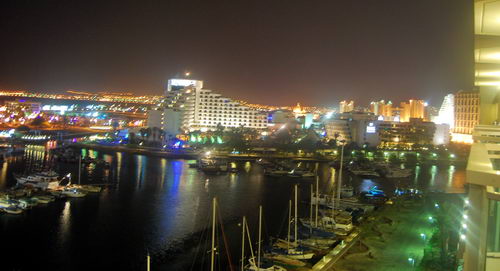
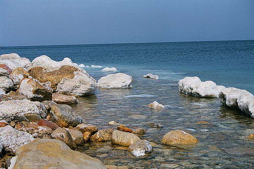
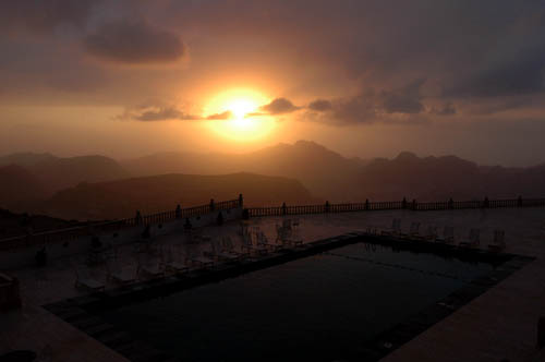
Last evening I made this photo looking east from my hotel balcony. We face the marina; the gulf is to the right (south) of this photo. The lights, behind the large hotels, are in Jordan.

East view from Eilat to Aqaba. Photo by Ferrell Jenkins.

East view from Eilat to Aqaba. Photo by Ferrell Jenkins.

The “promised land” was described to the Israelites as “a land whose stones are iron, and out of whose hills you can dig copper” (Deuteronomy 8:9). Copper was mined in the Negev (called the south in older English translations) as far back as the time of Solomon. Copper is still mined at Timna about 17 miles north of Eilat. Some years ago Belgian engineers made a survey proving the presence of 100,000 tons of metallic copper. Iron ore has been found in the Negev and in eastern Upper Galilee (Vilnay, The Israel Guide, 17).

The Bible does not say that Solomon had copper mines at Ezion-geber, but the presence of mining facilities dating to the time before Solomon indicates that this may have been one of the reasons why the King built a port and had a navy stationed there (1 Kings 9:26-28). Ezion-geber was more than 220 miles from Jerusalem. The copper provided a good medium of exchange for gold, spices, and other items that Israel needed.

In 1938, Nelson Glueck, reported that he had found a copper-refining plant at Tell el-Kheleifeh, which he identified as Ezion-geber, on the north shore of the Gulf of Aqaba (the Israelis call it the Gulf of Eilat).  The hotel in which we are staying in Eilat, Israel, is very near the border. Glueck identified Tell el-Kheleifeh as King Solomon’s copper mines, and explained that the apertures in the buildings served as flueholes. Through them, he thought, “the strong winds from the north-northwest entered into the furnace rooms of this structure,” which he called a “smelter, to furnish a natural draft to fan the flames.”

There is no question that copper smelting was done in the Negev in the time of Solomon, but Glueck later changed his mind about the building he had formerly identified as the refining plant. He later stated that the apertures in the building “resulted from the decay and or burning of wooden beams laid across the width of the walls for bonding or anchoring purposes.”

This does not affect any statement of the word of God, but it does mean that the old argument about the copper refining plant found in the Arabah is no longer valid. Glueck’s identification of Tell el-Kheleifeh with Ezion-geber is no longer accepted.

The tendency now is to identify Tell el-Kheleifeh with Elath (Eloth). Pharaoh’s Island (Jezirat Faraun) or Coral Island is suggested as the location of Ezion-geber. This island is located about 8 miles south of Eilat. It is now in Egyptian control so I was unable to see it on this trip, but I saw it a few
years ago.

It may be that our comfortable hotel is located on a spot where Israelites once camped.

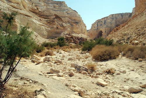
This morning we visited Timna Park which is located 17 miles north of Eilat. The Egyptians mined and smelted copper here in the 13th-12th centuries B.C. We saw the excavations conducted by Beno Rothenberg that provided evidence of the copper smelting. I don’t have enough time tonight to give a full explanation, and I have already written a lot for one day.

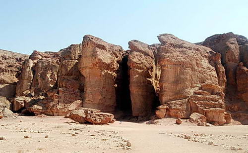
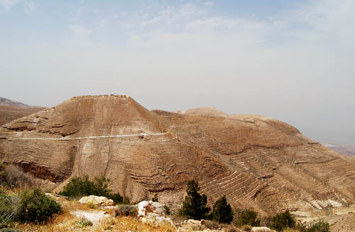
Timna Park is filled with beautiful, colorful, desert landscapes. One of the formations is known as Solomon’s Pillars. Of course, it has nothing to do with Solomon, but the name is nice.

The so-called Solomon's Pillars at Timna. Photo by Ferrell Jenkins.

The so-called Solomon's Pillars at Timna. Photo by Ferrell Jenkins.

The wilderness – Zin and Paran

Yesterday we drove from Beersheba to Eilat. The whole region is inhospitable and uninviting. Here is a photo of a section of the Wadi Zin. The wadi is dry now, but when there is rain it will become a river in the desert.

Wadi Zin. Photo by Ferrell Jenkins.

Wadi Zin. Photo by Ferrell Jenkins.

In Wadi Zin there are some small springs and a cool water pool. We did not take time to hike to the pool, but stopped by a small spring to watch the Ibex. Here is a young Ibex drinking water that reminds me of Psalm 42:1.

As a deer pants for flowing streams, so pants my soul for you, O God. (Psalm 42:1)

A young Ibex in Wadi Zin. Photo by Ferrell Jenkins.

A young Ibex in Wadi Zin. Photo by Ferrell Jenkins.

When the time came for Moses to die, the Lord told him that he would not be allowed to enter the promised land,

because you broke faith with me in the midst of the people of Israel at the waters of Meribah-kadesh, in the wilderness of Zin, and because you did not treat me as holy in the midst of the people of Israel. (Deuteronomy 32:51)

Today we visited the Yotvata Hai-Bar Nature Reserve, located about 20 miles north of Eilat in the Arabah. I made photos of many of the animals in the reserve.

A Somalia Wild Donkey at the Yotvata Hai-Bar Reserve. Photo by Ferrell Jenkins.

A Somalia Wild Donkey at the Yotvata Hai-Bar Reserve. Photo by Ferrell Jenkins.

Ishmael is described in these terms:

He shall be a wild donkey of a man, his hand against everyone and everyone’s hand against him, and he shall dwell over against all his kinsmen.” (Genesis 16:12)

Sometimes the LORD used simple facts to illustrate His wisdom. He asked Job,

“Who has let the wild donkey go free? Who has loosed the bonds of the swift donkey, (Job 39:5)

We are located less than a mile from the border with Jordan. In the afternoon we drove down to the Taba border crossing with Egypt. We also saw some of the beautiful coral and colorful fishes in the Red Sea.

The temperature today was 45 degrees celcius. Go figure! (For those of you who are metrically challenged, that is 113 degrees farenheit. It was really hot. We were expecting it to be 105!)

Was John the Baptist a member of the Dead Sea Sect?

Identifying the Dead Sea Sect. We are speaking of the Jewish group responsible for preparing and hiding the scrolls that were discovered in and around Qumran on the shores of the Dead Sea beginning in 1947. The sect living here was likely the Essenes. I am aware of the numerous controversies about Qumran, but have not been impressed by the alternative views.

Was John the Baptist an Essene? It has been popular among some scholars to claim that John was an Essene. A suggestion is made that John’s parents died while he was yet a child. The Essenes were known to have cared for orphan children. So, they cared for John. Some comparisons may be drawn concerning John and the Essenes.

  1. John was in the deserts (Luke 1:80). The Essenes were in the desert.
  2. Both John and the Essenes used Isaiah 40:3 to describe themselves as the voice in the wilderness.
  3. The baptism (or washing) practiced by John and the Essenes required a change of heart.

There are significant differences between John and the Essenes.

  1. The Essenes hid themselves away from society in the wilderness. John was a very public figure.
  2. John had a much more strict diet (Luke 7:33) than did the Essenes.
  3. John preached Jesus as the Messiah. The Essenes did not recognize Jesus as Messiah, but they thought that the Teacher of Righteousness would arise from within their group.
  4. There was a strong organization among the Essenes that is missing among John’s disciples.

In the early days of my study about the Dead Sea Scrolls I found the book by F. F. Bruce, Second Thoughts on the Dead Sea Scrolls. I am pleased to inform you that you may download this book free of charge here.

Here is a photo of Cave 4 at Qumran. Many of the important scrolls were located here.

Cave 4 at Qumran. Photo by Ferrell Jenkins.

Cave 4 at Qumran. Photo by Ferrell Jenkins.

John the Baptist at Machaerus

All four of the Gospels make some reference to the imprisonment of John the Baptist (Matthew 14:3,10; Mark 6:17; Luke 3:20; John 3:24). This must have been a significant and traumatic event for both the disciples of John and the disciples of Jesus.

Mark, the shortest gospel,  gives the most complete account of why Herod Antipas arrested and executed John. See Mark 6:17-32.

Josephus, the late first century Jewish historian, includes a long section about John in Antiquities 18:116-119. Perhaps another time we will take a closer look at all of it. For now, I am concerned with the place of execution.

Accordingly he was sent as prisoner, out of Herod’s suspicious temper, to Machaerus [or spell it Macherus], the citadel I before mentioned, and was there put to death. Now the Jews had an opinion that the destruction of this army was sent as a punishment upon Herod, and a mark of God’s displeasure to him. (Antiquities 18:119)

Josephus also records that Herod’s wife, the daughter of Aretas IV, king of Petra (the Nabateans), learned of his plan to divorce her and marry Herodias. Without telling Antipas that she knew, she asked for permission to be sent to Machaerus.I suspect that Herod was glad to get her out of town. She was no dummy. She had made arrangements for her father’s army to bring her safely [from Machaerus] to Arabia [perhaps Petra]. This event led to a war between the armies of Aretas and Herod Antipas. Herod’s army was destroyed. See Antiquities 18:109-115 for the full story.

Here is a brief summary about Machaerus.

  • Built by Alexander Jannaeus (102-75 B.C.).
  • Rebuilt by Herod the Great. This fortress is the eastern parallel to Masada.
  • Assigned to Herod Antipas at the death of Herod the Great (4 B.C.).
  • Destroyed by the Romans (A.D. 57).
  • Occupied by Jewish rebels (A.D. 66).
  • Captured by the Romans (A.D. 71).

Machaerus has an impressive location overlooking the Dead Sea from the east. There was so much haze (eastern sand) in the air the day we visited last April that it was not possible to see the Dead Sea below. This photo gives some idea of the terrain. The citadel is located about 2300 feet above sea level. This would make it about 3600 feet above the Dead Sea. The hill to the east, where I stood, is about 60 feet higher than the citadel.

Here is a view of some of the reconstructed ruins at the top.

Where was John buried? Mark tells us that his disciples “came and took away his body and laid it in a tomb” (6:29). Did they bury him at Machaerus? At Samaria? Neither the Bible nor Josephus inform us.

If you could use some nice photos of Machaerus to illustrate Bible lessons, I suggest you check out those by David Padfield here.

Pella of the Decapolis

The Jerusalem Post recently published an article about Pella under the title “Head for the hills.” The article is interesting, but is mostly speculation over whether Christians from Jerusalem found refuge in the Pella area at the time of the Roman destruction of Jerusalem (A.D. 70). It is not uncommon to find serious mistakes in articles of this type. They seem to be done hurriedly to meet a deadline. The article leaves the impression that Christ instructed the disciples “to reside for a while at Pella.” Here is the quotation:

“Christ having instructed them to leave Jerusalem and retire from it on account of the impending siege… to reside for a while at Pella.”

In fact, Eusebius says that the disciples were warned in advance, and that they fled to Pella. I have no stock in Eusebius, but see no reason to doubt what he says about this. Here is the statement from Eusebius:

The whole body, however, of the church at Jerusalem, having been commanded by a divine revelation, given to men of approved piety there before the war, removed from the city, and dwelt at a certain town beyond the Jordan, called Pella.

Anyway, if you would like to read the JP article, click here.

A few months back I prepared a short article for Biblical Insights about Pella, and thought I would share it with you here.

————

Pella was one of the cities of the Decapolis (Mt. 4:25; Mk. 5:20; 7:31). Pella is not mentioned in the Bible by name, but the location on the eastern side of the Jordan (Perea; “beyond the Jordan”) makes it likely that Jesus visited the area (Mt. 19:1; Mk. 10:1).

The term Decapolis was used to describe a group of ten cities established by the Greeks. Many of them claimed to have been founded by Alexander the Great. The number of cities may have been ten at some time, but the exact number varies from list to list. The cities include Abila [Lysanias was tetrarch of Abilene, Lk. 3:1], Gadara [Umm Qeis], Gerasa [Jerash], Hippos, Philadelphia [Amman], Scythopolis [Beth-shan], Pella, et al. These cities are located mostly south of the Sea of Galilee, and all except Scythopolis are east of the Jordan River. Damascus is included in some lists. In the first century A.D. they were part of the Roman province of Syria.

The cities of the Decapolis reflected the Hellenistic culture that had dominated the area since the days of Alexander. Jesus’ ministry took him “beyond the Jordan [east]” to “Galilee of the Gentiles” (Mt. 4:15; Isa. 9:1). It is here that we find a sizable number of swine (Mt. 8:28-34).

When Paul left Damascus to go away into Arabia, he would have traveled through the Decapolis area. And again on the return (Gal. 1:17).

Eusebius, the fourth century church historian of Caesarea Maritima, says that the church at Jerusalem, having been previously commanded by a divine revelation, left the city before the Romans destroyed it in A.D. 70. He says they fled to Pella (HE 3.5.5). This would have been in response to the teaching of Jesus recorded in Matthew 24, Mark 13, and Luke 21.

From a rest house above the mound one has a wonderful view of the tell and of the area to the west. From that point one can see (in the haze) Mount Gilboa, the Jezreel Valley (to the far right in our photo), and the city of Beth-shan across the Jordan Valley. The valley on the south side of Pella may have been the valley through which the Midianites fled from Gideon (Jud. 7). Surely the inhabitants of Jabesh-gilead would have come through this valley to take the body of Saul and his sons from the wall of Beth-Shan (1 Sam. 31:11-12).

The Dead Sea is dying!

Not exactly current news, but ABC News, Saturday, July 12, 2008, had a report about this. Read the story, and find a link to the video here. In a word, the Dead Sea is drying up because of a lack of water. Water that once flowed into the Dead Sea from the Jordan River is now being diverted primarily by Israel, and Jordan for domestic and agricultural use. The Jordan River no longer experiences the annual flooding that was known even fifty years ago. I have seen a tremendous change in the 41 years that I have been traveling in the area.

The Dead Sea is called the Salt Sea in the Bible (Genesis 14:3; Numbers 34:3, 12). Josephus knew the Dead Sea at Lake Asphaltites in Roman times (Antiquities 1.174; 15:168).

Many old sources have listed the Dead Sea as being 1,292 feet below sea level. According to a study in 2005, the sea was 1,368 feet below sea level. That number would be greater now. The lowest point in the United States is 282 feet below sea level, at Death Valley in California.

This photo shows encrustations of salt that build up on the rocks along the shore of the Dead Sea.

Here is a photo of a sign, a bit defaced, in Jordan at sea level showing a cross-section topography of the Dead Sea.

Lachish on July 4th

On July 4, 1980, I was participating in the excavation at Tel Lachish in Israel along with three of my colleagues from Florida College (James Hodges, Phil Roberts, and Harold Tabor). There were sizable numbers of participants from Israel, United States, Australia, South Africa, and Germany. In addition to the hard work out in the sun, we had some fun. On the morning of July 4th a few of the guys got an American flag and put together a drum and bugle corp and marched across the tel. Note especially the plastic bucket being used as a drum in this photo.

Lachish is identified with Tell ed-Duweir, located in the shephelah (lowlands) of Judah about 30 miles south west of Jerusalem. It is mentioned in Scripture during the period of the conquest (Joshua 10, 12, 15). Lachish served as one of the Judean store cities during the period of the kingdom Judah. Many of the LMLK jar handles have been found here. The city fell both to the Assyrians and the Babylonians.

Excavations were carried out by the British between 1932 and 1938 under the direction of J. L. Starkey. Starkey was murdered in 1938 while en route to the opening of the Palestine Archaeological Museum (later the Rockefeller Museum) in Jerusalem. Professor Yohanan Aharoni of Tel Aviv University excavated the “Solar Shrine” in 1966 and 1968. A new excavation was begun in 1973 under the auspices of The Institute of Archaeology of Tel Aviv University and The Israel Exploration Society. Dr. David Ussishkin served as the director until 1994.

One afternoon while we were in our tented camp a short distance from the tel, a bus load of Arabs from Jordan arrived. They had once lived in the area, prior to the founding of the State of Israel. Some of the older men had worked with Starkey. This photo which I took shows four of the Arab men and three of the Israeli archaeologists, along with one American. See if you recognize Gabriel Barkay, Richard Whitaker, Adam Zertal, and David Ussishkin.

The Arab men enjoyed seeing the old photos from the Starkey excavations and pointing out themselves as much younger men. I think you will see Ussishkin’s head to the left of the Arab, and Barkay on the right.

I thought you might enjoy this little bit of recent history from 28 years ago.

Update (July 6, 2008). Todd Bolen, at BiblePlaces.com has commented on this blog under the title Reminiscences of Lachish. He says he heard Gabriel Barkay tell about this event, but he includes some additional information that I did not know, including the name of the village where the Arabs previously lived.

The town of Qubeibe was leveled by the Israeli military in the 1960s and the stones of the village, probably many taken from the ruins of Lachish, were sold to building contractors.  Who knows but some ancient inscription was unknowing transferred from Lachish to Qubeibe and is now part of a wall in the area?

I recall that Richard Whitaker was the one best able to converse in Arabic.

Sunset over Edom

I ran across this beautiful sunset photo that I made from a hotel above Petra, Jordan, in 2006.

The oracle concerning Edom. One keeps calling to me from Seir, “Watchman, how far gone is the night? Watchman, how far gone is the night?” The watchman says, “Morning comes but also night. If you would inquire, inquire; Come back again.” (Isaiah 21:11-12)

There are some text critical issues with the term Edom in this verse, but I will leave that for you to work on. Keil and Delitzsch call attention to a comment by Luther that illustrates the certain judgment that would come upon ancient Edom, the descendants of Esau.

But what is the meaning? Luther seems to me to have hit upon it: “When the morning comes, it will still be night.”

The decline and fall of any nation ought to cause one to take a pause and think about it.

Ramoth in Gilead

Ramoth in Gilead (or Ramoth-gilead) was a town in Gilead that was included in the territory of the Israelite tribe of Gad in Transjordan (Joshua 20:8). It was one of the Levitical cities of refuge for the Israelites (Joshua 21:38). The most memorable associated with Ramoth-gilead recorded in the Bible is the battle with Aram (Syria) in which Ahab was killed (1 Kings 22). Elijah sent one of the sons of the prophets to Ramoth-gilead to anoint Jehu as king of Israel (2 Kings 9:1).

The identity of Ramoth-gilead is uncertain. Two sites are frequently mentioned by scholars: Tall ar-Rumeith and Ar-Ramtha.

Burton MacDonald, in East of the Jordan, says,

There is also archaeological support for choosing Tall ar-Rumeith, situated in the fertile plain area just to the southeast of the junction of the ‘Amman-Damascus and Irbid-Mafraq highways, as the location for Ramothgilead. (page 200)

Paul Lapp excavated at Tall ar-Rumeith in 1967. Little archaeological work has been done at Ar-Ramtha. I have not gone into the Jordanian city of Ramtha, but understand that the mound is covered by the town, thus making it difficult to conduct an excavation.

Here is a photo I made at Tall ar-Rumeith in 2002. It is not surprising to see camels here because the desert is near (to the east). From the top of the tell there is a great view looking north across a fertile plain to the border with Syria.

Earlier this year I went back to the site, but found that some modern housing has been built adjacent to the east side of the tell. It appears to be serving as housing for Indian students. I speculate that they attend a nearby university.

This photo shows a modern trench made to make a road to part of the construction site.

We found some pottery in the road, but can not be certain that it came from the damage to the tell. I did not see any shards along the edge of the cut.

This illustrates a real problem associated with ancient sites in isolated places. In a place like Jordan there are so many sites that it is impossible to excavate, preserve, and guard all of them.

A note on spelling. You may note different spellings of the word describing an archaeological mound. In Israel the term Tel is used. Earlier the term Tell was used throughout the Middle East. In Jordan the term Tall has come into common use.

There is also much variation in the spelling of some of the compound biblical names in scholarly sources, and even in English translation of the Bible. This is illustrated in this post and the previous one on Bethshan.