Category Archives: Archaeology

Rainy days in Galilee

We visited the area north of the Sea of Galilee today. Gentle rain was still falling when I first looked out at the Sea of Galilee this morning. By the time we reached Hazor the weather had cleared and we had a bright and sunny visit. A light rain fell at Dan, but at Caesarea Philippi there was a downpour like I have never seen during one of my tours.

After lunch there was clearing and we returned to the site for a more complete visit.

The right amount of rain is a wonderful blessing from the LORD. He promised His people that he would send the early rains and the late rain. The late rain comes about this time of year, and we are expecting more the next two days.

“It shall come about, if you listen obediently to my commandments which I am commanding you today, to love the LORD your God and to serve Him with all your heart and all your soul, that He will give the rain for your land in its season, the early and late rain, that you may gather in your grain and your new wine and your oil. “He will give grass in your fields for your cattle, and you will eat and be satisfied.  (Deuteronomy 11:13-15 NAU)

The rain is a good thing to help correct a long-term drought that has afflicted Israel in recent years. Nowhere have we seen this more clearly than at the Sea of Galilee.

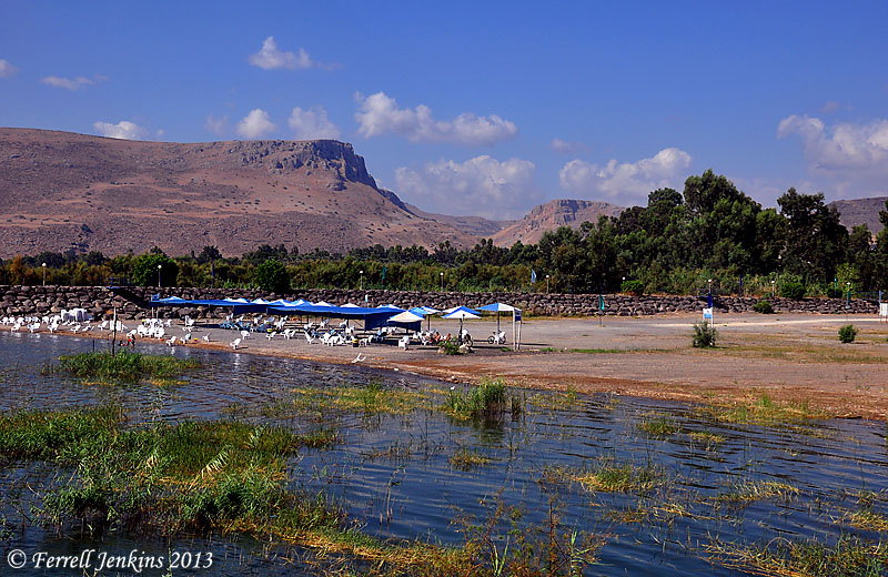
Here is a photo I made yesterday at Nof Ginosaur in the Biblical Gennesaret (Matthew 14:34). I walked out to the end of the pier that has been built to allow boats to drop off passengers.

Sea of Galilee at Nof Ginosaur, April 18, 2913. Photo by Ferrell Jenkins

Sea of Galilee at Nof Ginosaur, April 18, 2913. Photo by Ferrell Jenkins

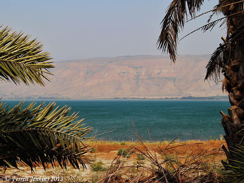
And here is the same area in September, 2012.

The Sea of Galilee at Nof Ginosar, September, 2012. Photo by Ferrell Jenkins.

The Sea of Galilee at Nof Ginosar, September, 2012. Photo by Ferrell Jenkins.

Kinneret Bot reports for April 18 that the Sea of Galilee is –209.94 meters below sea level. Americans typically translate that as –688.78 feet. A year ago the level was –693.44 feet (211.36 meters) bsl.

Touring Israel again

We completed our second full day of study in Israel today. The photo below shows our guide explaining the geographical/topographical features of the area around a site northeast of the Sea of Galilee. The site is known as et-Tell, and is identified by some as the New Testament site of Bethsaida, and perhaps the Old Testament site of Geshur.

Bethsaida is listed in the New Testament as the home of Andrew, Peter, and Philip (John 1:44; 12:21).

The land of Geshur was located in this same area. David married Maacah, the daughter of Talmai, king of Geshur (2 Samuel 3:3). Absalom, the son of David and Maacah, spent three years in Geshur after he killed his half-brother Amnon (2 Samuel 13:30-38; cf. 14:23, 32).

Tour group at "Bethsaida". Photo by Ferrell Jenkins.

Tour group at et-Tell. Photo by Ferrell Jenkins.

While traveling I do not have time to elaborate on the arguments about the identity of this site with Bethsaida.

Mysterious structure in the Sea of Galilee

Scientists report the discovery of a mysterious structure in the Sea of Galilee on the SW “corner” near the site of Bet Yerah.

According to Live Science here, this structure is made of large basalt blocks. These volcanic stones are common in the region.

A giant “monumental” stone structure discovered beneath the waters of the Sea of Galilee in Israel has archaeologists puzzled as to its purpose and even how long ago it was built.

The mysterious structure is cone shaped, made of “unhewn basalt cobbles and boulders,” and weighs an estimated 60,000 tons the researchers said. That makes it heavier than most modern-day warships.

Rising nearly 32 feet (10 meters) high, it has a diameter of about 230 feet (70 meters). To put that in perspective, the outer stone circle of Stonehenge has a diameter just half that with its tallest stones not reaching that height.

You will need to check the Live Science report, or the original scholarly article from International Journal of Nautical Archaeology (Vol. 42: Issue 1; March 2013) here or here (pdf). There you will find a map, photos and drawings of the structure.

I stopped very near the spot of the structure to make some photos of ripe date palms a few years ago.

The Sea of Galilee near Bet Yerah. The view is to the east across this narrow southern end of the lake. Photo by Ferrell Jenkins.

The Sea of Galilee near Bet Yerah. The view is to the east across this narrow southern end of the lake. Photo by Ferrell Jenkins.

Whatever this structure and it purpose, it seems to have existed long before any of the biblical activity recorded in the region.

HT: Joseph I. Lauer

Ancient Sumerian site excavated

Mike Addelman, Press Officer of the Faculty of Humanities at the University of Manchester, has been kind enough to provide us with some photos of the recent excavation of Tell Kahiber.

Some of us might easily drive past the ancient mound without realizing that it was an ancient archaeological site. Prof. Stuart Campbell and Dr. Jane Moore, both of Manchester University, and independent archaeologist Robert Killick, first recognized important features of the tell on satellite images.

Early stages of excavation at ancient settlement mound of Tel Khaiber. Photo by Prof. Stuart Campbell, University of Manchester.

Early stages of excavation at ancient settlement mound of Tel Khaiber. Photo by Prof. Stuart Campbell, University of Manchester.

Tell Kahiber is located close to Tell Mugheir, thought by some scholars to be the biblical Ur of the Chaldeans, the home of Abraham (Genesis 11:28-31; 15:7). Historically we know this area to be Sumer. The following map from Bible Atlas shows the general area.

Area of ancient Sumer. BibleAtlas.org

Area of ancient Sumer. BibleAtlas.org

The New International Dictionary of Biblical Archaeology points out,

There are no direct references to Sumer in the Bible, although it corresponds to the “land of Shinar” mentioned eight times in the OT.

Amraphel is designated as the king of Shinar (Genesus 14:1). Notice a couple of other references.

The beginning of his [Nimrod] kingdom was Babel, Erech, Accad, and Calneh, in the land of Shinar. (Genesis 10:10 ESV)

And as people migrated from the east, they found a plain in the land of Shinar and settled there. (Genesis 11:2 ESV)

One of the most striking finds thus far is a plaque, about 3½ inches high, showing a worshiper approaching a sacred place. He is depicted as wearing a long robe with fringe down the front opening. Images such as this one help us to think of the clothing that may have been worn by Abraham and his family.

One of the most striking finds to date is a clay plaque, 9cm high, showing a worshiper approaching a sacred place. Photo by Prof. Stuart Campbell, University of Manchester.

One of the most striking finds to date is a clay plaque showing a worshiper approaching a sacred place. Photo by Prof. Stuart Campbell, University of Manchester.

This information is being broadcast via several news outlets. You may read the press release from Manchester University here.

Crucified skeleton found near Jerusalem

The Romans were adept at crucifixion, according to many historical sources. The first archaeological evidence of crucifixion was uncovered in 1978 [1968; see comments] when an ossuary (bone box, or receptacle) was found north of Jerusalem containing the bones of a man who had been crucified. His name was “Yehohanan, the son of Hagakol.” He is thought to have been between 24 and 28 years of age, and was about 5 feet 6 inches in height.

Both the ossuary and a replica of the heel bone are displayed in the Israel Museum. When Yehohanan was removed from the cross the nail pulled away from the wood.

Ankle bone of a man crucified outside Jerusalem in Roman times. Photo by Ferrell Jenkins.

Nail through the heel bone of a man crucified outside Jerusalem in Roman times. Display in Israel Museum. Photo by Ferrell Jenkins.

On Pentecost, Peter proclaimed the truth about Jesus. He said,

This man was handed over to you by God’s deliberate plan and foreknowledge; and you, with the help of wicked men, put him to death by nailing him to the cross. (Acts 2:23 NIV)

No ossuary, or bones belonging to Jesus, have ever been found. The angel at the empty tomb of Jesus announced to the women who had gone to complete the burial,

He is not here, for he has been raised, just as he said. Come and see the place where he was lying. (Matthew 28:6 NET)

Rock tomb with rolling stone near Jezreel Valley. Photo by Ferrell Jenkins.

Rock tomb with rolling stone near Jezreel Valley. Photo by Ferrell Jenkins.

SourceFlix has posted a nice brief video of Passion Week Archaeology here.

Hidden treasure

The discovery of hidden treasure is fairly common in and near ancient sites. Individuals may not have a bank account, but they keep the funds they have stored in what they consider a safe place.

The photo below shows a clay jar with a hoard of silver coins displayed in the Samsun (Turkey) Archaeological Museum. These coins date from the Roman Imperial Period (69-79 A.D. and 238/244 A.D.). The earliest coins are not far removed from the time of the delivery of Peter’s Epistles to saints in Pontus and other Roman provinces (1 Peter 1:1). For more information about the delivery of Peter’s Epistles, see here.

For more information about the museum, check here and here.

Hoard of Roman coins displayed in Samsun Archaeological Museum. Photo by Ferrell Jenkins.

Roman coins displayed in Samsun Archaeological Museum. Photo by Ferrell Jenkins.

Photos such as this remind us of several Biblical passages. For today, consider Paul’s instruction to Timothy regarding what he was to teach those who set their hope on the uncertainty of riches.

 17 As for the rich in this present age, charge them not to be haughty, nor to set their hopes on the uncertainty of riches, but on God, who richly provides us with everything to enjoy.
18 They are to do good, to be rich in good works, to be generous and ready to share,
19 thus storing up treasure for themselves as a good foundation for the future, so that they may take hold of that which is truly life. (1 Timothy 6:17-19 ESV)

Restoration of historic sections of Izmir (biblical Smyrna)

Izmir is looking for local input on a restoration plan of the historic areas of Kadifekale and the agora.

On my last visit to Izmir I could see new work underway, especially in the area of the agora. The city now is developing a plan to restore an area of the city to make it more desirable for local citizens as well as tourists.

An article in Hurriyet Daily News (here) reports,

Municipal authorities in İzmir are calling for public participation amid an ambitious new project to redevelop some of the Aegean province’s most famous tourists sites in a bid to draw more visitors.

“We want to share ideas with scientists and the residents of İzmir. If we cannot get the support of citizens, it will not be possible to realize this project,” İzmir Metropolitan Mayor Aziz Kocaoğlu said.

Our first photo shows a portion of the Roman agora. The arches which appear to be at ground level are actually the lower level of a two-story building.

The Roman agora of Izmir, biblical Smyrna. Photo by Ferrell Jenkins.

The Roman agora of Izmir, biblical Smyrna. Photo by Ferrell Jenkins.

The second photo was made from the agora, with a view of Kadifekale. The word Kadifekale means velvet castle. In ancient times this hill was called Mount Pagos. The article mentions plans to include a restored area on the mountain, including the theater which was built on the hillside. Mark Wilson says the ancient theater, now build over by houses, seated 16,000 persons (Biblical Turkey, 312).

A view of Kadifekale (Mount Pagos) from the agora. Photo by Ferrell Jenkins.

A view of Kadifekale (Mount Pagos) from the agora. Photo by Ferrell Jenkins.

Smyrna is mentioned in the Bible as the location of one of the Seven Churches addressed in the book of Revelation (the Apocalypse).

“And to the angel of the church in Smyrna write: ‘The words of the first and the last, who died and came to life. (Revelation 2:8 ESV; see also 1:11)

Here’s hoping for a speedy and accurate restoration of the ancient city.
HT: Jack Sasson

Video about King Herod exhibit

CBN.tv has a nice brief video about the King Herod exhibit at the Israel Museum. This video features the exhibit as well as commentary by James Snyder, Israel Museum Director, and Dr. Sylvia Rozenberg, the Senior Curator. Here you will learn the rationale behind the million dollar exhibit that emphasizes Herod as a builder.

Click here for the short video.

For previous links to King Herod and this exhibit click here, or type the word Herod in the Search Box.

HT: the Book & the Spade.

The theater at Beth-shean — a show of history

Beth-shean is mentioned only a few times in the Old Testament. The English Standard Version uses both Beth-shan and Beth-shean for this town. Other English versions use a variety of spellings including Bethshan.

During one of my recent trips to Beth-shean I sat in the Roman theater and thought about the show of history that passed before my eyes. In the distance was the ancient tell, called Tell el-Husn or Tel Beth She’an, from which one has an impressive view of the area. Occupational levels date back at least to 3000 B.C. Artifacts from Canaan, Egypt, Anatolia, north Syria, and Mesopotamia have been uncovered from the mound.

For many Bible students the first event that comes to mind is the defeat of King Saul at the hands of the Philistines. After his death on nearby Mount Gilboa, Saul’s body was taken to Beth-shean and fastened to the wall of the city (1 Samuel 31).

View of Bethshan from the Roman theater. Photo by Ferrell Jenkins.

View of Tel Beth-Shean from the Roman theater. Photo by Ferrell Jenkins.

During the Greek period the city was named Scythopolis (city of the Scythians) and expanded to the foot of the tell.

In 63 B.C. the Romans, under the general Pompey, made the city part of the Decapolis (a league of ten cities; Matthew 4:25; Mark 5:20; 7:21). This was the only city of the Decapolis west of the Jordan River. The city was populated by gentiles, Jews and Samaritans.

The city grew to its largest size during the Byzantine period as a “Christian” city. It came under Muslim control in A.D. 636, and was destroyed by an earthquake in A.D. 749.

The destroyed Byzantine city lies between the theater and the mound. That’s a lot of history in one small place.

Clarence Stanley Fisher — Armageddon

Clarence Stanley Fisher was trained as an architect at the University of Pennsylvania in his hometown of Philadelphia. He became involved in archaeology at Nippur, Iraq (the region of ancient Sumer). Later he worked with George Andrew Reisner at Giza, Egypt, and then at Samaria from 1908 to 1910. This expedition, sponsored by Harvard, was the first American excavation in Palestine. After a short time back at Giza, he excavated at Beth Shan (Beit She’an), a dig sponsored by the University of Pennsylvania.

Fisher received an invitation from the University of Chicago to work at Megiddo, a work funded by the Rockefeller family. This excavation continued from 1933 to 1939, but fisher stopped working at the site after two years because of bad health.

The Megiddo excavations were recounted by Fisher under the title The Excavation of Armageddon, a work published by the University of Chicago Press with a foreword written by James Henry Breasted. This work is available at Google Books.

From 1936 to the time of his unexpected death in 1941, Fisher served as Professor of Archaeology at the American Schools of Oriental Research in Jerusalem (now the Albright Institute).

Fisher is buried at the Protestant Cemetery on Mount Zion in Jerusalem.

Grave marker for Clarence Stanley Fisher. Photo by Ferrell Jenkins.

Grave marker for Clarence Stanley Fisher. Photo by Ferrell Jenkins.

The brief information I have included here is summarized from a brief article by Milton C. Fisher in Bible and Spade 6:2 (Spring 1993). I get the impression that Milton is not related to Clarence. Milton Fisher cites two comments about C. S. Fisher that I wish to quote here.

W. F. Albright described Fisher as “an archaeological genius of no mean quality.”

Nelson Glueck wrote the following at the time of his death:

“The company of his friends misses him sorely. The host of those who loved him for his goodness of heart and humility of spirit will cherish the memory of this gentle man, whose last pilgrimage was to Nazareth, and whose final resting place is in Jerusalem.”

I find it fascinating to see so many well-known names associated with Fisher when Americans and American institutions were actively working in the Middle East.