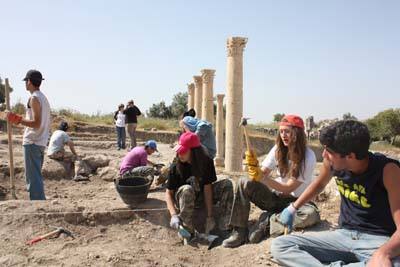
Jordanian students from the International Academy Amman spent a week excavating at Umm Qais. The full article may be read in The Jordan Times here.

Students from the International Academy in Amman work at Um Qais. Photo by Taylor Luck, Jordan Times.
Umm Qais (a common spelling) is the site of Gadara, one of the cities of the Decapolis. Mendel Nun discovered 16 ancient ports around the Sea of Galilee, including one for the city of Gadara. He describes Gadara:
Gadara, the most magnificent of the Hellenistic towns that circled the Sea of Galilee, was located on the heights of Gilead above the Yarmuk River. The marine suburb and the city’s harbor were located on the southeastern shore of the lake, at Tel Samra (now Ha-on Holiday Village). In form, Gadara’s harbor resembles that of Sussita—a closed basin with an opening to the south—but it is much larger and more luxurious. The central breakwater is 800 feet long and its base 15 feet wide. The promenade was 650 feet long, built with finely chiseled stones, only one of which remains. The 150-foot-wide basin covered an area of 3 acres.
This harbor is superior to the one at Sussita not only because of its size but also because of its facilities. At the center of the promenade are the remains of a tower. Ruins of a large structure—probably the building of the harbor administration—are scattered on the ground near the harbor gate.
Gadara’s maritime character is attested by its coins, which depicted ships of war for some 250 years. The city’s harbor at Tel Samra was almost certainly not only an anchorage for ships. Second-century coins from Gadara commemorate the Naumachia—naval battle games performed for the inhabitants of Gadara. Until recently, researchers assumed that these games took place on the Yarmuk River, which flows into the Jordan just south of the Sea of Galilee; but this does not seem likely, and no remains of a facility of this kind have been found at this site. The large harbor basin at Tel Samra, however, with its 1,600-foot-long combined promenade and breakwater, would surely have been more suitable to accommodate the throngs of spectators as they arrived. In addition, Gadara’s harbor must have been used by thousands of visitors to the famous baths at Hamat Gader, located 5 miles southeast of the sea. The ancient Roman road connecting Beth Shean and Sussita passed near Tel Samra, and the road to Hamat Gader branched off this road. (Mendel Nun. “Ports of Galilee.” Biblical Archaeology Review 25:04; July/Aug 1999)
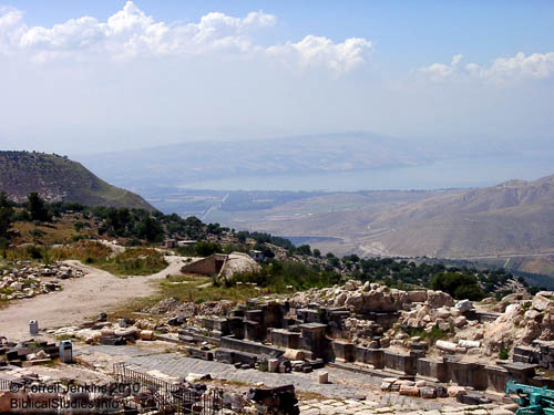
From Umm Qais (Gadara) one has a great view of the Sea of Galilee and the Yarmuk River valley. We are told that Jesus visited the region of Decapolis.
Then he returned from the region of Tyre and went through Sidon to the Sea of Galilee, in the region of the Decapolis. (Mark 7:31 ESV)
The Gospel of Matthew informs us about the healing by Jesus of two demon-possessed men in the country of the Gadarenes (Matthew 8:28). Mark puts this event in the country of the Gerasenes (Mark 5:1-20). Luke adds that they “sailed to the country of the Gerasenes, which is opposite Galilee” (Luke 8:26).
The photo below was made in the late afternoon when citizens of the local Jordanian village came out to enjoy the view. The view across the Sea is not clear, but you can see the entire western coast line. In the right foreground you can see a bunker used by the Jordanians in recent wars in the region. The hill directly across from the bunker is the beginning of the Golan Heights. Prior to 1967 this was in Syria. The Yarmuk River flows into the Jordan River south of the Sea of Galilee. All of the significant rivers of Jordan that flow into the Jordan River have dams on them, thus decreasing the amount of water flowing into the Jordan.
The next photo was made in 2002. It shows a portion of the nymphaeum (attractive water fountain) and the Yarmuk Valley.
Todd Bolen posted a beautiful, clear photo that also shows the Yarmuk River valley and the nymphaeum here. Note that the nymphaeum had undergone some reconstruction when his photo was made.
HT: Joseph Lauer


You must be logged in to post a comment.