Tag Archives: West Bank

A day in the West Bank

There was a time that it was easy to visit sites in the Palestinian West Bank. That is no longer true. Car rental companies will not permit their cars to be taken into the West Bank. We hired a driver and vehicle (4WD) to take us several places. I think we were fortunate to obtain the services of a tourist bus driver who happened to have a day free. Even for him going into the West Bank was not easy.

First it is necessary to choose the appropriate border crossing. Then instead of taking what formerly was the most direct route drivers must go in circles to avoid running into the fence (or wall). This is especially true near Jerusalem.

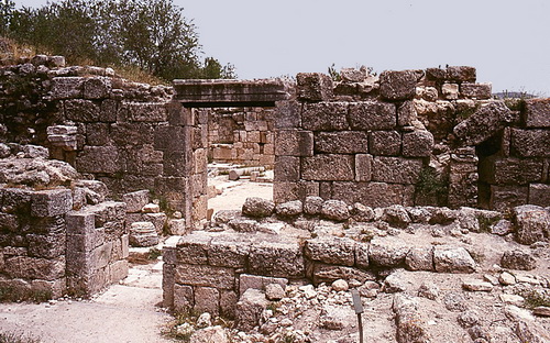
Our first stop was Gibeon (Joshua 9-10). The last time I was there to see the excavations by James Pritchard of the University of Pennsylvania I drove directly to the ruins. This time it was extremely difficult to reach the same ruins. We were successful in our efforts and got some good photos that we hope to share later.

We also stopped at Shiloh where the tabernacle was set up after the ancient Israelites entered Canaan  (Joshua 18:1). A team from the Israel Antiquities Authority was excavation in three different areas low on the tel in areas mostly from the Islamic and Byzantine period.

Next we went to Mount Gerizim to visit the Samaritans Museum. Husney W. Cohen, a priest and director of the Museum, was kind to show us around and explain the Samaritan viewpoint about several biblical events. Samaritans believe the temple was to be built on Mount Gerizim rather than Jerusalem. They think Abraham offered Isaac on the mountain. They accept only the first five books (the Pentateuch) of the Old Testament. In this photo you see Cohen, myself, and Leon Mauldin with the ancient scroll. This scrolls look to be much newer, or better preserved, than the old one I photographed many years ago (here).

wSamaritan Scroll at Mount Gerizim

Samaritan Scroll at Mount Gerizim. Husney W. Cohen, Ferrell Jenkins, Leon Mauldin.

I understood Husney W. Cohen to say that he was third in line to become the High Priest of the Samaritans.

We had hoped to visit the archaeological work on Mount Gerizim, but it was closed due to some construction.

We made a short stop at Jacob’s well (John 4). Then we visited the new Tel Balata Archaeological Park. Tel Balata is the site of biblical Shechem (Genesis 12:1). While in Nablus we also made a short stop at the traditional Tomb of Joseph (Joshua 24:32).

We left the central mountain rain through Wadi Farah (now called Wadi Tirza by the Israelis.   We were short on time and did not try to stop at Tirza (1 Kings 15:33). The springs that once flowed through the valley are now practically dry. I understand this is because the water is being piped away by Israel for use by the settlements.

We stopped at Jericho and made a visit to Tell es-Samarat (the site of Herod’s hippodrome) and Herod;s Palace (Matthew 2). New signs have been erected to point to these places, but the roads to them are terrible. The sites are in terrible condition and there are no explanatory signs.

In the future we hope to show some photo of some of these places.

Places less visited in Israel

Today we got a fairly early start and went through the Shephelah to Lachish. This takes about an hour or so from Jerusalem. We did not go to visit Lachish, but to continue east to a small kibbutz called Shekef. From here we would try to locate Tel Eiton (also Tel ‘Eton and Tel Aitun). I had been in the area before but did not locate the tel. The reason for going so far out of the way to get to the site is that it is situated on Israel’s border with the Palestinian West Bank. Just before reaching Shekef we began to  drive on the new highway 358 to Beersheba, parallel to the border. Soon we realized that we must be bypassing the place we want to go.

We backtracked and eventually after doing what men “never do”, ask for directions, we located Tel Eiton. Palestine is on the east side of the mound and a military firing range is on the west side. We decided it would be best to stick to the gravel road without straying too far to the left or the right — sort of like Joshua.

“Be very firm, then, to keep and do all that is written in the book of the law of Moses, so that you may not turn aside from it to the right hand or to the left,  so that you will not associate with these nations, these which remain among you, or mention the name of their gods, or make anyone swear by them, or serve them, or bow down to them.  (Joshus 23:6-7 NAU)

Tel Eiton currently is equated with biblical Eglon by many scholars. Recent excavations have been conducted under the direction of Prof. Avi Faust, now of Bar Ilan University.

Here is a photo of the tel from the south and perhaps a little to the east.

Tel Eiton (Tel Aitun), possibly biblical Eglon.

Tel Eiton (Tel Aitun) from the south (and east). Photo by Ferrell Jenkins.

Eglon is mentioned at least eight times in the Bible, all in the book of Joshua (10:3, 5, 23, 34, 36, 37; 12:12). The Scripture emphasizes that Israel defeated the king of Eglon. Notice the relationship between Lachish, where we started our trek, and Eglon.

And Joshua and all Israel with him passed on from Lachish to Eglon, and they camped by it and fought against it.  They captured it on that day and struck it with the edge of the sword; and he utterly destroyed that day every person who was in it, according to all that he had done to Lachish.  Then Joshua and all Israel with him went up from Eglon to Hebron, and they fought against it.  (Joshua 10:34-36 NAU)

We also visited the following places.

Tel Bet Mirsim, a site identified as Debir by William F. Albright (Joshua 10:38, 39). Albright identified Tel Eiton as Libnah, but scholars today question this.

Tel Halif, north and slightly east of Beersheba, is thought by some to be biblical Ziklag, . Others place the biblical city at Tel Shera, northwest of Beersheba.

Finally we visit the Brook Besor and Tel el-Farah South. Israel calls the site Tel Sharuhen (1 Samuel 30). This tel is located in the Plain of Philistia, not far from the borders with Egypt and the Gaza Strip.

Hopefully we will be able to share more photos and information about this places with you at a later time. It is all very fascinating to the student of the Bible. Right now it is too late and I need to be sleeping.

Model shrines from biblical sites

Model shrines have been uncovered in numerous excavations of biblical cities, but they are common throughout the Ancient Near East. Ziony Zevit says,

Some model shrines were found to contain built-in images of deities while others were empty. In the latter case, some scholars assume that a small portable image was placed inside when the shrine was in use. (The Religions of Ancient Israel, 328).

The model shrines come in a variety of sizes. Here is one excavated at Tell el-Farah, the biblical site of Tirzah.

Model shrine from Tell el Farah. The Louvre. Photo by Ferrell Jenkins.

Model shrine from Tell el Farah. The Louvre. Photo by Ferrell Jenkins.

Tirzah served as the capital of the northern kingdom of Israel during the reigns of Baasha (1 Kings 15:21) Elah and Zimri (1 Kings 16:17-18). Omri reigned six years in Tirzah before he purchased the hill of Samaria and moved the capital of Israel there (1 Kings 16:24).

The shrine discovered at Ashkelon is significant because it included a silver plated bull. See a low quality photo here.

Luke Chandler reports on the 2010 discovery of a shrine at Khirbet Qeiyafa, and includes two nice photos here.

Underground quarry discovered in Jordan Valley

Israeli papers are reporting the discovery of an underground quarry in the Jordan Valley. Prof. Adam Zertal and a team of archaeologists from the University of Haifa are working on the hypothesis that this is the site of biblical Gilgal.
The biblical account in Joshua reads,
Now the people came up from the Jordan on the tenth of the first month and camped at Gilgal on the eastern edge of Jericho. Those twelve stones which they had taken from the Jordan, Joshua set up at Gilgal. (Joshua 4:19-20 NAU)
The report in Ha’aretz gives more information about the discovery.

A spectacular underground quarry has recently been discovered in the Jordan Valley north of Jericho, which archaeologists believe may have marked a biblical site sacred to ancient Christians.

The large cave was discovered by Prof. Adam Zertal and a team from the University of Haifa which has been conducting a survey of the region since 1978. “When we reached the entrance to the cave, two Bedouin approached us and warned us not to go in, because it was cursed and inhabited by wolves and hyenas,” Zertal said yesterday from the site.

They entered anyway, discovering a ceiling supported by 22 gigantic columns on which various symbols were carved, including 31 crosses, a possible wheel of the Zodiac and a Roman legionary symbol. The columns also had niches for the placement of oil lamps and holes that apparently served as hitching posts.

Jordan Valley cave. Photo courtesy of University of Haifa.

Jordan Valley cave. Photo courtesy of University of Haifa.

The Ha’aretz article continues,

Zertal says their working theory is that the site is Galgala, biblical Gilgal, mentioned on the sixth-century Madaba mosaic map. The cave, buried 10 meters underground, is about 100 meters long, 40 meters wide and 4 meters high, is the largest artificial cave so far discovered in Israel.

Potsherds found in the cave and the carvings on the columns led Zertal to date the first quarrying of the cave to around the beginning of the Common Era. It was used mainly as a quarry for 400 to 500 years, “but other finds give the impression it was used for other purposes, perhaps a monastery or even a hiding place,” Zertal said.

Zertal said scholars wondered why people would dig a quarry underground considering the effort needed just to pull the stones out of the ground.

A possible answer may be in the famous Madaba Map of ancient Palestine, found in Jordan. In it, a place named Galgala is marked and an accompanying Greek word meaning “12 stones.” The map also depicts a church near the site. Archaeologists say they have found two ancient churches near the cave.

According to Zertal, scholars had always assumed that “12 stones” referred to the biblical story of the 12 stones the Israelites set up at Gilgal after they crossed the Jordan. However, the discovery of the quarried cave may mean the reference was to a quarry established where the Byzantines identified Gilgal. Zertal explains that in antiquity sanctuaries were built out of stones from sacred places.

If the Byzantines identified the site as biblical Gilgal, it would have been considered sacred and quarrying would have remained underground to preserve it.

Here is a photo of a portion of the Madaba Map that I made last year.

Madaba Map showing Gilgal, Jericho, Jordan River. Photo by Ferrell Jenkins.

Madaba Map showing Gilgal, Jericho, Jordan River. Photo by Ferrell Jenkins.

This portion of the map shows the northern end of the Dead Sea and the Jordan River. You will notice fish turning around when they reach the Dead Sea. I think everyone can make out the city of palm trees, IERIXW (Jericho, Deuteronomy 34:3). To the north of Jericho, and a little east toward the river, is the site of Gilgal.

The inscription reads “Galgala, also the twelve stones.” Below the inscription is a small church with its entrance hidden by a long structure with 12 white spots on it (two rows of six). The Madaba map is dated to about A.D. 560 to 565. You may read more about the Madaba Mosaic Map here.

HT: Joseph I. Lauer

UPDATE: A short video showing the cave and featuring Dr. Zertal is available from BBC here.

Almonds – a symbol of watchfulness and old age

Almonds were also among the best products of the land sent by Jacob to the man in Egypt (Genesis 43:11). The Hebrew word for almond (seqedim) comes from the root sqd which means “to watch, wake.” King and Stager tell us that the name was given because,

its splendid white blossoms appear as early as the end of January, a true harbinger of spring. Jeremiah plays on sqd: “The word of Yahweh came to me [Jeremiah], saying, ‘Jeremiah, what do you see?’ And I said, ‘I see a branch of an almond tree (saqed).’ Then Yahweh said to me, ‘You have seen well, for I am watching (soqed) over my word to perform it” (Jer. 1:11-12). (Life in Biblical Israel, 105)

The photo below was made in early March near the north border of the Palestinian West Bank near Jenin. Notice that the falling blossoms turn the ground gray.

Almond trees blooming in the West Bank. Photo by Ferrell Jenkins.

Almond trees blooming in the West Bank near Jenin. Photo by Ferrell Jenkins.

Other biblical references to the almond include the following:

  • The cups of the lampstand for the tabernacle were shaped like almond blossoms (Exodus 25:33).
  • Aaron’s rod sprouted and brought forth buds, produced blossoms, and bore ripe almonds (yummy; Numbers 17:8).
  • Used figuratively of the person growing older (“the almond tree blossoms,” Ecclesiastes 12:5). Matthew Henry says, “The old man’s hair has grown white, so that his head looks like an almond-tree in the blossom. The almond-tree blossoms before any other tree, and therefore fitly shows what haste old age makes in seizing upon men; it prevents their expectations and comes faster upon them than they thought of. Gray hairs are here and there upon them, and they perceive it not.”
Almond blossoms in the West Bank. Photo by Ferrell Jenkins.

Almond blossoms in the West Bank. Photo by Ferrell Jenkins.

John the Baptist and Samaria

I am in the process of preparing some material on John the Baptist in Biblical and Church History. There is a tradition that John was buried at Samaria. This is one of those late traditions that reflect the understanding of believers in the centuries following the time of John.

Jerome Murphy-O’Connor makes some comments on this in the fifth edition of The Holy Land. See our earlier reference to the book here.

Christian tradition very quickly (before 361) identified Samaria as the site of the infamous birthday party at which Herod Antipas had John the Baptist executed (Mark 6:17-29). With greater probability Josephus locates the murder at Machaerus in Jordan (Antiquities 18:119). This information, however, was not available to all Christians, and the much more accessible Samaria was associated with the name of Herod, who had held a wedding party there and much later executed two of his sons there. The fact that the two Herod’s were father and son would not have bothered the popular credulous mind. Two churches were built in John’s honour, one near Herod’s temple and the other in the modern village. (The Holy Land, 5th edition, 461)

Samaria is in the West Bank of Israel, under the Palestinian Authority. It has been impossible to visit Samaria on a regular basis for many years. My last visit was in 2000, but I was trying to use the “latest” in digital technology. The photos are not very good. Another thing to remember about important sites like this is that they are not well maintained. Here is a photo of the Church of St. John that I have scanned from a 1984 slide.

At the Biblical Studies Info Page I keep a list of good sources for photos (check Scholarly, then Photos). None of these have a photo of this site. On May 19, 2005, some scholars associated with the Studium Biblicum Franciscanum in Jerusalem made a visit to Sebaste (Samaria). There are several good photos of approximately 800 x 600 pixels, with commentary. These are stashed away in the archives of the web site. Perhaps you can access them here. These photos include the Iron Age site belonging to the time of the Divided Kingdom, and the Herodian and Roman site from the time of the New Testament (Acts 8).

Here is a comment from the Franciscan site about the two churches at Sebaste identified with John.

The Alleged Discovery of the Baptist’s Head. It is not known what happened to the head consigned to Herodias; but as early as the fourth century, stories begin to appear about the finding of the supposed relic. One such inventio took place in Sebaste in the place regarded as the Baptist’s prison. A church associated with this discovery was erected near the acropolis, while the large church containing the tomb was below to the east, in the cemetery area.

The cathedral from the mid-12th century, now a mosque, is said to enshrine the tomb of John the Baptist. The church is in the village of Sebaste. I am taking the liberty of showing you the photo of the exterior of the church from the SBF web site.