Category Archives: Photography

“Cracked Pot Archaeology”

If you have not taken a look at Life and Land by Gordon Franz, I suggest you do so now. Gordon is a careful scholar. His material is always well researched and documented. One category that caught my attention at Life and Land is called Cracked Pot Archaeology. Here is how he describes this category.

The Cracked Pot Archaeology category contains articles about popular, contemporary archaeological theories and ideas that, like cracked pots, hold no water! These articles are a review, scholarly analysis and critiques of theories and ideas that have been presented on the Internet or popular books, movies, DVD’s and videos.

Over the past few years Gordon has written a number of articles about the claims of the late Ron Wyatt and Robert Cornuke. Last evening I presented a lesson on “Ports of Paul.” I only had time to talk about Caesarea Maritima and the events of Acts 27-28 (Malta, Syracuse, and Rhegium). I called attention to the claim of Robert Cornuke and the response by Gordon Franz. You will find his response to Cornuke’s book, The Lost Shipwreck of Paul, under the category of Paul and Places. Gordon provides information about the possible places on Malta where the shipwreck may have occurred. I will leave any discussion of that at this time, and let you enjoy working through his material.

The photo below shows Mellieha Bay on Malta. Beyond the bay you may see the island of Gozo. Mellieha Bay is a few miles north of St. Paul’s Bay, the traditional site of the shipwreck. We discussed several places on Malta back in September here, here, and a few other places (use the Search box to locate places you are studying).
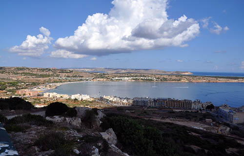
Mellieha Bay, Malta. Photo by Ferrell Jenkins.

Mellieha Bay, Malta. Photo by Ferrell Jenkins.

One of Gordon’s recent articles is a response to Cornuke’s claim to have found an inscription with the name of Yahweh on it. Read it here. The final sentence by Franz sums it up:

The assertion that Mount Sinai is at Jebel al-Lawz in Saudi Arabia still lacks credible and verifiable historical, geographical, archaeological, or biblical evidence.

You will find links to articles dealing with the claim that Jebel al-Lawz in Saudi Arabia is Mount Sinai.

A word of warning. Beware of someone who has discovered something all others have overlooked. Be especially wary if they have found two things no one else knows about. Shall I keep counting?
Video of high waves at Caesarea Maritima

December 13th I wrote about the high waves at the Herodian harbor of Caesarea Maritima here.  While in Israel I tried to post a short video I made, but it did not play smoothly and I gave up. Back home, I note that it plays correctly on my home computer. See if you get a good play.

If you have trouble playing the video, try the direct link here.

Headed for home

We are now at the Ben Gurion International Airport awaiting our non-stop flight from Tel Aviv to Atlanta. It takes about 11 -/+ hours on the westbound flight. The flight does not leave Tel Aviv until about 11:30 p.m. Hopefully this will give a good opportunity for some sleep on the way home.

Leon and I consider that our trip has been a success. We have had fairly good weather most of the time. We were able to visit a number of places that we had not previously visited. Some were fairly easy to reach, and others were difficult. I don’t know the total number of photos each of us made, but it was a lot. Perhaps in the months to come you will see some of these photos in presentations we make, in journals, and online.

We have missed our families while engaging in what we believe is important in our work as preachers and teachers of the Word. We look forward to seeing them tomorrow.

Thanks for following our travels. Please continue to check the blog from time to time. I usually post something at least 4 or 5 times a week; sometimes more often. The posts over the past two weeks have only touched the hem of the garment of the places we have visited. Use the search box to find posts about biblical places in which you may be interested.

The Herodian Family Tomb

In the morning we visited Nabi Samwil, the traditional tomb of the prophet Samuel. Some scholars think this may be the biblical Mizpah. Others believe that Mizpah should be identified by Tell en-Nahbeh.

Now Samuel called the people together to the LORD at Mizpah. (1 Samuel 10:17 ESV)

The site at Nabi Samwil provides a great view of the biblical territory of Benjamin.

Later we went to the traditional family tomb of Herod the Great (37 – 4 B.C.) which is located on the west side of the Old City, and behind the famous King David Hotel. We know from Josephus that Herod buried certain family members in Jerusalem (Wars 1:581). Herod was buried at the Herodium near Bethlehem.

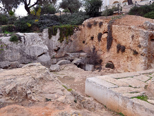
This first photo shows the general area of the tomb which is cut from solid rock.

Herodian Family Tomb in Jerusalem. Photo by Ferrell Jenkins 2009.

Herodian Family Tomb in Jerusalem. Photo by Ferrell Jenkins 2009.

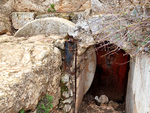
The photo below shows the rolling stone. In more recent time a door has been places at the opening of the tomb. Murphy-O’Connor says the tomb was found empty because robbers got there before the archaeologists (The Holy Land).

Herodian Family Tomb in Jerusalem. Photo by Ferrell Jenkins 2009.

Herodian Family Tomb Rolling Stone. Photo by Ferrell Jenkins 2009.

We also visited the Skirball Museum at the Hebrew Union College. Some artifacts from Gezer and Dan have been displayed at this small museum. Today we learned that the museum is closed. The lady at the reception desk said she did not know when or if it would be opened. She allowed us to look at a few items displayed in cases along a corridor among the offices. This was a disappointment. One item of interest that is in the poorly lit cases is a replica of the inscription from Dan that mentions the “god” who is in Dan.

The site of Kiriath-jearim is now Abu Ghosh

Conditions for photography today were about the best I have seen. We had a busy day but have run out of time to write very much. We have one more day before this wonderful study and research opportunity comes to an end.

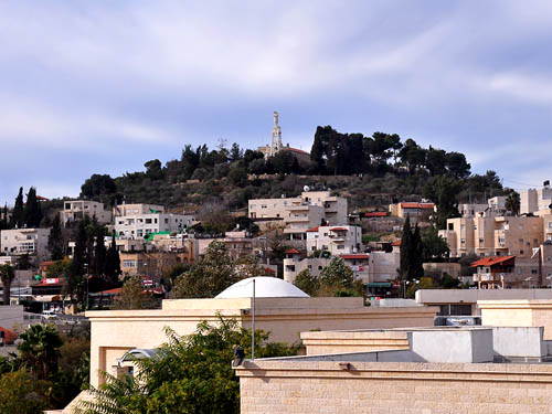
This morning we stopped in the Judean Hills, about nine miles west of Jerusalem, at the Arab town of Abu Ghosh. This is the biblical site of Kiriath-jearim (or Kiriath Jearim).

Kiriath-jearim’s highest honor is in the association with the ark of the covenant. The Israelites took the ark from the tabernacle at Shiloh to the battle field at Ebenezer when they were fighting with the Philistines (1 Samuel 4). The ark was captured by the Philistines and taken to Ashdod, then to Gath, and finally to Ekron before they decided to get rid of it. The ark was returned to Beth-shemesh (1 Samuel 4-6).

The men of Beth-shemesh sent messengers to the residents of Kiriath-jearim asking them to come and take the ark to their town. The ark was brought into the house of Abinadad on the hill. His son, Eleazar, was consecrated by the men of the city to keep the ark of the LORD. The ark remained there for many years until David had it brought to Jerusalem (1 Samuel 6:21-7:2; 2 Samuel 6).

The town of Abu Ghosh, site of biblical Kiriath-jearim. Photo by Ferrell Jenkins.

The town of Abu Ghosh, site of biblical Kiriath-jearim. Photo by Ferrell Jenkins.

Our photograph shows the hill of Kiriath-jearim. Our Lady of the Ark of the Covenant Church was built in 1911 on the ruins of a fifth century Byzantine church.

Museums and Tels

It was cloudy this morning, so we decided to visit the Eretz Israel Museum on our way from the coastal plain to Jerusalem. The Eretz Israel Museum on the campus of Tel Aviv University is built around Tel Qasile, a Philistine city established in the mid-12th century B.C. A sign at the site calls this the port city of the period of the kings and judges of Israel.

The excavation of Tel Qasile, Israel’s first archaeological dig, began in 1949 under Prof. Benjamin Mazar and uncovered three stages in the city’s history (strata XII-X). During the 10th cent. B.C.E. conquest of the region by King David, the city was destroyed by fire. Later rebuilt. It became part of the kingdom of David and Solomon (strata IX-VIII). Lebanese cedars, used to build the temple in Jerusalem, may have been transported via Tel Qasile.

Abandoned during the divided kingdom period, Tel Qasile was settled during the time of King Josiah (stratum VII) and from the Persian period to the Middle Ages (strata VI-I).

The Bible indicates that the Cedar was brought by sea to Joppa, but perhaps Tel Qasile was close enough to Joppa to have been used. It is near the Yarkon River. King Hiram is quoted as saying,

And we will cut whatever timber you need from Lebanon and bring it to you in rafts by sea to Joppa, so that you may take it up to Jerusalem. (2 Chronicles 2:16 ESV; cf. Ezra 3:7)

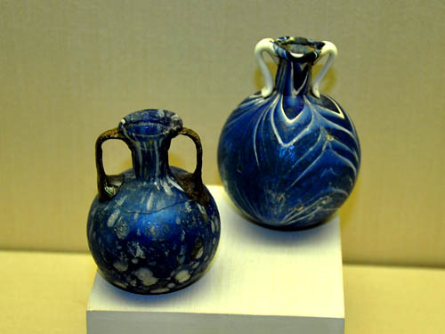
The museum is composed of several buildings. One has a good section on copper mining at Timna, north of Eilat. There are buildings devoted to glass, coins and stamps. Several examples of winepresses are located on the grounds. The glass museum has the finest collection of first century glass that I have seen.

Free-blown perfume bottles from 1st century A.D. Photo by Ferrell Jenkins 2009.

Free-blown perfume bottles from 1st century A.D. Photo by Ferrell Jenkins 2009.

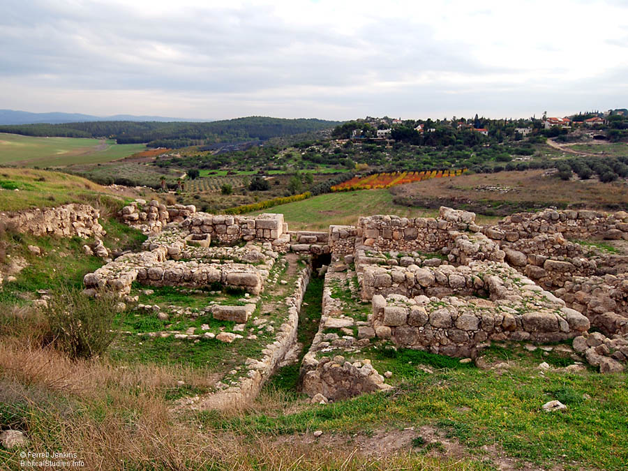
On the way to Jerusalem we stopped by Gezer. The tel is visible from a good highway, but it is difficult to reach. It is another of those tels that can not be reached without taking dirt roads through fields. Gezer was  discovered by Clermont-Ganneau in 1871. It was first excavated by R.A.S. Macalister between 1902 and 1905. A major excavation was carried out from 1964-1974. The most recent excavation began in 2007.

This photo shows what is often called the Solomonic Gate. It is a six-chambered gate similar to those discovered at Hazor and Megiddo. You may click on the photo for a larger image suitable for use in teaching presentations.

"Solomon's Gate" at Gezer. Photo by Ferrell Jenkins.

"Solomon's Gate" at Gezer. Photo by Ferrell Jenkins 2009.

And this is the account of the forced labor that King Solomon drafted to build the house of the LORD and his own house and the Millo and the wall of Jerusalem and Hazor and Megiddo and Gezer. (1 Kings 9:15 ESV)

The mountains of Judea are visible in the distance. Photograhically, it was a good day.

High waves at Caesarea Maritima

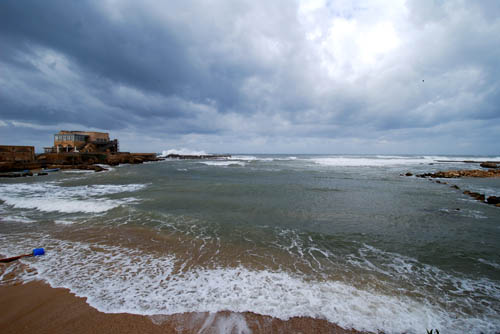
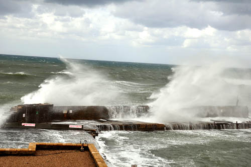
Friday evening we stayed in the plain of Sharon with friends and former students. We had selected some sites north of there to visit today, but the weather forecast indicated that the weather would be bad. The forecast for the area around Tel Aviv looked better so we went to Caesarea Maritima. When we arrived there was some sun. I noticed the waves were much higher than I had ever seen and those crashing into the breakwater splashed high into the air.

The first photo shows the site of the Herodian harbor. I rented a wide angle lens for this trip to be able to make photos of this type.

Harbor at Caesarea Maritima with high waves

Harbor at Caesarea Maritima with high waves. Photo by Ferrell Jenkins.

Look carefully at the breakwater to the right of the building on the left of the photo. You will see the splash of the waves high above the breakwater. The next photo shows a closeup of the same area. The splash appear to almost touch the clouds.

Caesarea Maritima harbor with high waves

High waves splashing against the breakwater. Photo by Ferrell Jenkins.

Caesarea Maritima was a first century Roman capital and seaport. The gospel was first preached to the Gentiles here when Peter came from Joppa to Caesarea to tell Cornelius words by which he could be saved (Acts 10, 11).

Herod the Great built a city on the site of Strato’s Tower and named it Caesarea in honor of Caesar Augustus. It became a center of Roman provincial government in Judea. The city had a harbor and was located on the main caravan route between Tyre and Egypt. This city is called Caesarea Maritima (on the sea) to distinguish it from Caesarea Philippi.

The Apostle Paul used the harbor at Caesarea several times. He was imprisoned here for two years before departing for Rome (Acts 24:27; 27:1).

A little storm on the Sea of Galilee

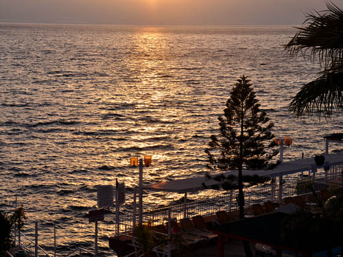
Friday morning I looked out the hotel window on the Sea of Galilee. First I noticed that it was clear — something for which I had been wishing. I also noticed that there were uncommonly high waves on the lake. The palm fronds were moving with the wind. By the time I made the photo below, as the sun was rising over the eastern hills, the waves were not at high. This photo may illustrate what I am talking about.

Sea of Galilee at Sunrise with Little Storm

Sea of Galilee at Sunrise with a Little Storm. Photo by Ferrell Jenkins.

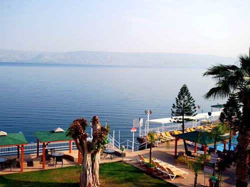
The next photo was made about noon from the same spot as the one at 6 a.m. At this time the sea is calm and fairly clear. Many who have taken a boat ride across the Sea of Galilee can attest to the calmness and quietness of the water.

Sea of Galilee from Ron Beach Hotel

Sea of Galilee from Ron Beach Hotel at noon. Photo by Ferrell Jenkins.

I was able to make a short video of the sea when the waves were higher and the wind was strong. Notice the sea gulls; you can even hear their call.

If there is any problem with the video, you should be able to go directly to it on YouTube here.

What is the explanation for such sudden storms on the sea? Notice the account given by Luke.

22 One day he got into a boat with his disciples, and he said to them, “Let us go across to the other side of the lake.” So they set out,  23 and as they sailed he fell asleep. And a windstorm came down on the lake, and they were filling with water and were in danger.  24 And they went and woke him, saying, “Master, Master, we are perishing!” And he awoke and rebuked the wind and the raging waves, and they ceased, and there was a calm.  25 He said to them, “Where is your faith?” And they were afraid, and they marveled, saying to one another, “Who then is this, that he commands even winds and water, and they obey him?” (Luke 8:22-25 ESV)

Luke explains in verse 23 that “a windstorm came down on the lake.” Such storms are produced by winds from the west and northwest that come down into the basin where the Sea of Galilee is located. These storms often occur in the late afternoon when the cooler air comes down on the hot air in the basin.

Before we left the hotel we said something to one of the owners about the morning storm. He said, “It was only a little storm; not a big one.” I am sure that is correct, but it does illustrate how these storms happen.

In the Galilee

We spent two days at Tiberias on the Sea of Galilee at a lovely smaller hotel called Ron Beach Hotel. I had stayed there once before and wanted to return. It is family owned and operated. The staff is friendly and the meals are good. The hotel is situated on the north side of Tiberias as you head toward Magdala and Tabgha.

Thursday morning heavy clouds covered the Sea of Galilee. Only occasionally the sun broke through to provide a glimmer across the water. We went to a few places where we could make photos on the shore of Galilee. We visited the Church of the Primacy. This is the traditional site where Jesus met with the disciples after the resurrection. The events are recorded in John 21. The disciples had fished during the night and caught nothing. At day break Jesus invited them to “Come and have breakfast.”

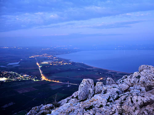
We also visited Hazor and Kedesh. In the late afternoon we went to Mount Arbel for a magnificent view of the northern portion of the Sea of Galilee. We were a little late. The photo you see below was made in the dark with a long exposure and the use of a tripod. The land below is known in the New Testament as the Land of Gennesaret.

And when they had crossed over, they came to land at Gennesaret. (Matthew 14:34)

The Sea of Galilee from Mount Arbel at night. Photo by Ferrell Jenkins.

The Sea of Galilee from Mount Arbel at night. Photo by Ferrell Jenkins.

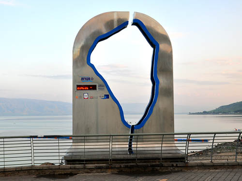
When we mentioned rain to the locals, they spoke of how badly they needed rain. There was evidence of rain in several of the places we visited. Due to drought conditions the Sea of Galilee is extremely low. This sea level indicator at Tiberias shows the level to be 214.31 meters below sea level. That is 703.12 feet.

Sea of Galilee Level Indicator at Tiberias

Sea of Galilee Level Indicator at Tiberias. Photo by Ferrell Jenkins.

The Israel Ministry of Environmental Protection has determined if the Sea of Galilee drops below 214.87 meters [704.95 feet] below sea level “the pumps in the lake can no longer operate.”

The risks associated with reduced water levels are formidable: ecosystem instability and deterioration of water quality, damage to nature and landscape assets, receding shorelines and adverse impacts on tourism and recreation. When the black line is reached, the pumps in the lake can no longer operate.

According to the Water Authority, Lake Kinneret lost 5.13 meters [16.83 feet] since the spring of 2004, equivalent to some 850 million cubic meters of water.

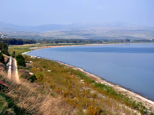
Everywhere around the lake one can see evidence that the water level is low.

The NW area of the Sea of Galilee. Photo by Ferrell Jenkins.

The NW area of the Sea of Galilee. Photo by Ferrell Jenkins.

Water once covered the area where you see grass. You may know that there are brackish springs at Taghba. This water is channeled around the sea to the Jordan River, so the sea remains fresh water. The concrete channel may be seen in the left of the picture.

Perhaps tomorrow I will have time to tell you about the little storm we saw on the sea this morning.

The waterfall at En Gedi

Yesterday Leon Mauldin made a short video of one of the waterfalls at En Gedi. He agreed for me to share this with you.

When David was fleeing from King Saul he visited En Gedi (or Engedi). There are a series of beautiful waterfalls at En Gedi. Everyone has to have water, and it would be difficult to think that David did not visit these waterfalls.

Then David went up from there and stayed in the strongholds of En Gedi. (1 Samuel 23:29)

Thursday we visited some interesting places in the Galilee. Hopefully I will be able to post a few photos later.