Category Archives: Israel

The ESV Study Bible

Quite a bit of attention is being given to the forthcoming (October 15) English Standard Version Study Bible. Dr. Leen Ritmeyer has served as archaeological and architectural editor for the new study Bible. On his blog he calls attention to two interviews with Justin Taylor, Project Director and Managing Editor of the ESV Study Bible.

The first interview is “What Did Calvary Look Like?” Evidence for the Church of the Holy Sepulcher and the Garden Tomb is summarized. Golgotha on this drawing is now the site of the Church of the Holy Sepulcher.

Drawing showing Golgotha.

Drawing showing Golgotha.

The second interview is “What Did Jesus’ Tomb Look Like?”

If you teach the Bible you will want to download the large drawings associated with these interviews. Some sample pages in PDF (Introductions to Luke, Revelation, and Psalms) are available for download here.

Taylor explains the high quality of these drawings (“paintings”):

Using Dr. Ritmeyer’s extensive research and new drawings, we then turned to the illustration firm Maltings Partnership (in Derby, England) to produce the final, full-color paintings. We knew of Maltings’ superb work from their reconstruction drawings in the DK Travel Guides and the National Geographic Traveler guides. We could not be happier with the final results.

Second Temple Model in new location

For years the model of Jerusalem from the time of the second temple was displayed on the grounds of the Holyland Hotel in Jerusalem. When the hotel needed the space to enlarge, the decision was made to relocate the model on the grounds of the Israel Museum. This was a wonderful decision. It is now possible to visit the model, the Shrine of the Book, and the archaeology museum with one stop. Also, the Bible Lands Museum is across the road.

Second Temple at the time of Herod and Christ? I know that Bible students wonder about this designation. In our Bible classes we often point out that the temple was first built by Solomon, king of Israel (970-931 B.C.). That temple was destroyed by the Babylonians in 586 B.C. The temple was rebuilt after the return from the Babylonian Exile in the days of the Persian King Darius (520-516 B.C.). If we consider Herod’s work a remodeling of the second temple, then I suppose we could think of it as the second temple. Herod’s work was so massive that we probably should think of it as the third temple. Herod began this work about 19/20 B.C. There is a reference to the long project in the gospel of John.

John 2:19-22  Jesus answered them, “Destroy this temple, and in three days I will raise it up.”  20 The Jews then said, “It took forty-six years to build this temple, and will You raise it up in three days?”  21 But He was speaking of the temple of His body.  22 So when He was raised from the dead, His disciples remembered that He said this; and they believed the Scripture and the word which Jesus had spoken. (John 2:19-22)

Here is a photo I made in April of the model which is based on available literary and archaeological evidence. In the background you see the Knesset of Israel and the Shrine of the Book where some of the Dead Sea Scrolls are displayed.

Second Temple Model of Jerusalem at its new location

Absalom, John the Baptist, and Zechariah

The Kidron Valley in Jerusalem has several ancient tombs in it. The Bible records that Absalom, son of King David, built a monument for himself in the King’s Valley.

Now Absalom in his lifetime had taken and set up for himself the pillar that is in the King’s Valley, for he said, “I have no son to keep my name in remembrance.” He called the pillar after his own name, and it is called Absalom’s monument to this day. (2 Samuel 18:18 ESV)

The so-called Absalmon's Monument in the Kidron Valley

In AD 1170 Benjamin of Tudela associated one of the monuments in the Kidron Valley with the monument of Absalom. The monument actually belongs to the early first century B.C. It is a funerary monument in front of an eight-chambered tomb.

Joe Zias, of Hebrew University, was able to locate an inscription on the right side of the monument in 2002. The inscription is written in Byzantine Greek of the fourth century AD and reads,

This is the tomb of Zacharias, martyr, very pious priest, father of John.

Could this be the priest Zacharias (also spelled Zechariah in English versions) who was the father of John the Baptist? I think the best we can do is agree with Murphy-O’Connor,

Such Byzantine identifications reflect the piety of the period and have no historical value.

John the Baptist and Samaria

I am in the process of preparing some material on John the Baptist in Biblical and Church History. There is a tradition that John was buried at Samaria. This is one of those late traditions that reflect the understanding of believers in the centuries following the time of John.

Jerome Murphy-O’Connor makes some comments on this in the fifth edition of The Holy Land. See our earlier reference to the book here.

Christian tradition very quickly (before 361) identified Samaria as the site of the infamous birthday party at which Herod Antipas had John the Baptist executed (Mark 6:17-29). With greater probability Josephus locates the murder at Machaerus in Jordan (Antiquities 18:119). This information, however, was not available to all Christians, and the much more accessible Samaria was associated with the name of Herod, who had held a wedding party there and much later executed two of his sons there. The fact that the two Herod’s were father and son would not have bothered the popular credulous mind. Two churches were built in John’s honour, one near Herod’s temple and the other in the modern village. (The Holy Land, 5th edition, 461)

Samaria is in the West Bank of Israel, under the Palestinian Authority. It has been impossible to visit Samaria on a regular basis for many years. My last visit was in 2000, but I was trying to use the “latest” in digital technology. The photos are not very good. Another thing to remember about important sites like this is that they are not well maintained. Here is a photo of the Church of St. John that I have scanned from a 1984 slide.

At the Biblical Studies Info Page I keep a list of good sources for photos (check Scholarly, then Photos). None of these have a photo of this site. On May 19, 2005, some scholars associated with the Studium Biblicum Franciscanum in Jerusalem made a visit to Sebaste (Samaria). There are several good photos of approximately 800 x 600 pixels, with commentary. These are stashed away in the archives of the web site. Perhaps you can access them here. These photos include the Iron Age site belonging to the time of the Divided Kingdom, and the Herodian and Roman site from the time of the New Testament (Acts 8).

Here is a comment from the Franciscan site about the two churches at Sebaste identified with John.

The Alleged Discovery of the Baptist’s Head. It is not known what happened to the head consigned to Herodias; but as early as the fourth century, stories begin to appear about the finding of the supposed relic. One such inventio took place in Sebaste in the place regarded as the Baptist’s prison. A church associated with this discovery was erected near the acropolis, while the large church containing the tomb was below to the east, in the cemetery area.

The cathedral from the mid-12th century, now a mosque, is said to enshrine the tomb of John the Baptist. The church is in the village of Sebaste. I am taking the liberty of showing you the photo of the exterior of the church from the SBF web site.

Pella of the Decapolis

The Jerusalem Post recently published an article about Pella under the title “Head for the hills.” The article is interesting, but is mostly speculation over whether Christians from Jerusalem found refuge in the Pella area at the time of the Roman destruction of Jerusalem (A.D. 70). It is not uncommon to find serious mistakes in articles of this type. They seem to be done hurriedly to meet a deadline. The article leaves the impression that Christ instructed the disciples “to reside for a while at Pella.” Here is the quotation:

“Christ having instructed them to leave Jerusalem and retire from it on account of the impending siege… to reside for a while at Pella.”

In fact, Eusebius says that the disciples were warned in advance, and that they fled to Pella. I have no stock in Eusebius, but see no reason to doubt what he says about this. Here is the statement from Eusebius:

The whole body, however, of the church at Jerusalem, having been commanded by a divine revelation, given to men of approved piety there before the war, removed from the city, and dwelt at a certain town beyond the Jordan, called Pella.

Anyway, if you would like to read the JP article, click here.

A few months back I prepared a short article for Biblical Insights about Pella, and thought I would share it with you here.

————

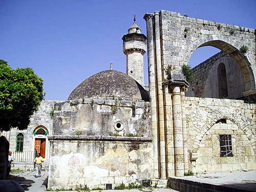
Pella was one of the cities of the Decapolis (Mt. 4:25; Mk. 5:20; 7:31). Pella is not mentioned in the Bible by name, but the location on the eastern side of the Jordan (Perea; “beyond the Jordan”) makes it likely that Jesus visited the area (Mt. 19:1; Mk. 10:1).

The term Decapolis was used to describe a group of ten cities established by the Greeks. Many of them claimed to have been founded by Alexander the Great. The number of cities may have been ten at some time, but the exact number varies from list to list. The cities include Abila [Lysanias was tetrarch of Abilene, Lk. 3:1], Gadara [Umm Qeis], Gerasa [Jerash], Hippos, Philadelphia [Amman], Scythopolis [Beth-shan], Pella, et al. These cities are located mostly south of the Sea of Galilee, and all except Scythopolis are east of the Jordan River. Damascus is included in some lists. In the first century A.D. they were part of the Roman province of Syria.

The cities of the Decapolis reflected the Hellenistic culture that had dominated the area since the days of Alexander. Jesus’ ministry took him “beyond the Jordan [east]” to “Galilee of the Gentiles” (Mt. 4:15; Isa. 9:1). It is here that we find a sizable number of swine (Mt. 8:28-34).

When Paul left Damascus to go away into Arabia, he would have traveled through the Decapolis area. And again on the return (Gal. 1:17).

Eusebius, the fourth century church historian of Caesarea Maritima, says that the church at Jerusalem, having been previously commanded by a divine revelation, left the city before the Romans destroyed it in A.D. 70. He says they fled to Pella (HE 3.5.5). This would have been in response to the teaching of Jesus recorded in Matthew 24, Mark 13, and Luke 21.

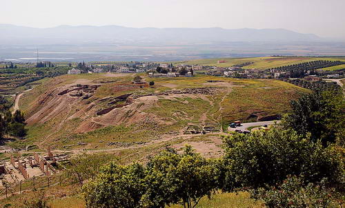
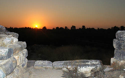
From a rest house above the mound one has a wonderful view of the tell and of the area to the west. From that point one can see (in the haze) Mount Gilboa, the Jezreel Valley (to the far right in our photo), and the city of Beth-shan across the Jordan Valley. The valley on the south side of Pella may have been the valley through which the Midianites fled from Gideon (Jud. 7). Surely the inhabitants of Jabesh-gilead would have come through this valley to take the body of Saul and his sons from the wall of Beth-Shan (1 Sam. 31:11-12).

The Dead Sea is dying!

Not exactly current news, but ABC News, Saturday, July 12, 2008, had a report about this. Read the story, and find a link to the video here. In a word, the Dead Sea is drying up because of a lack of water. Water that once flowed into the Dead Sea from the Jordan River is now being diverted primarily by Israel, and Jordan for domestic and agricultural use. The Jordan River no longer experiences the annual flooding that was known even fifty years ago. I have seen a tremendous change in the 41 years that I have been traveling in the area.

The Dead Sea is called the Salt Sea in the Bible (Genesis 14:3; Numbers 34:3, 12). Josephus knew the Dead Sea at Lake Asphaltites in Roman times (Antiquities 1.174; 15:168).

Many old sources have listed the Dead Sea as being 1,292 feet below sea level. According to a study in 2005, the sea was 1,368 feet below sea level. That number would be greater now. The lowest point in the United States is 282 feet below sea level, at Death Valley in California.

This photo shows encrustations of salt that build up on the rocks along the shore of the Dead Sea.

Here is a photo of a sign, a bit defaced, in Jordan at sea level showing a cross-section topography of the Dead Sea.

Sunset at Lachish

This photo was made from inside the gate at Lachish looking west toward the Mediterranean Sea. The city faced two significant sunsets. It fell to the Babylonians in 587 B.C. The Lachish Letters were found immediately outside this gate in a room on the left. My friend and colleague, the late Phil Roberts, worked in the gate when we were at Lachish in 1980. Phil continued to work there each year until the excavation came to a close. When the prophet Jeremiah wrote, only Lachish and Azekah remained of the fortified cities of Judah (Jeremiah 34:7).

Lachish fell to the Assyrians more than a hundred years earlier in 701 B.C.The Bible records the events after the fall of Samaria this way,

Now in the fourteenth year of King Hezekiah, Sennacherib king of Assyria came up against all the fortified cities of Judah and seized them. Then Hezekiah king of Judah sent to the king of Assyria at Lachish, saying, “I have done wrong. Withdraw from me; whatever you impose on me I will bear.” So the king of Assyria required of Hezekiah king of Judah three hundred talents of silver and thirty talents of gold. Hezekiah gave him all the silver which was found in the house of the LORD, and in the treasuries of the king’s house. At that time Hezekiah cut off the gold from the doors of the temple of the LORD, and from the doorposts which Hezekiah king of Judah had overlaid, and gave it to the king of Assyria. Then the king of Assyria sent Tartan and Rab-saris and Rabshakeh from Lachish to King Hezekiah with a large army to Jerusalem. So they went up and came to Jerusalem. And when they went up, they came and stood by the conduit of the upper pool, which is on the highway of the fuller’s field. (2 Kings 18:13-17)

Sennacherib was unable to capture Jerusalem. I take it that the destruction of Lachish was his greatest achievement because he plastered the walls of his palace in Nineveh. This photo shows the king receiving the surrender of Lachish.

The cuneiform inscription reads as follows:

Sennacherib, king of the world, king of Assyria, sat upon a (nîmedu) -throne and passed in review the booty (taken) from Lachish (La-ki-su). (ANET 288).

Lachish on July 4th

On July 4, 1980, I was participating in the excavation at Tel Lachish in Israel along with three of my colleagues from Florida College (James Hodges, Phil Roberts, and Harold Tabor). There were sizable numbers of participants from Israel, United States, Australia, South Africa, and Germany. In addition to the hard work out in the sun, we had some fun. On the morning of July 4th a few of the guys got an American flag and put together a drum and bugle corp and marched across the tel. Note especially the plastic bucket being used as a drum in this photo.

Lachish is identified with Tell ed-Duweir, located in the shephelah (lowlands) of Judah about 30 miles south west of Jerusalem. It is mentioned in Scripture during the period of the conquest (Joshua 10, 12, 15). Lachish served as one of the Judean store cities during the period of the kingdom Judah. Many of the LMLK jar handles have been found here. The city fell both to the Assyrians and the Babylonians.

Excavations were carried out by the British between 1932 and 1938 under the direction of J. L. Starkey. Starkey was murdered in 1938 while en route to the opening of the Palestine Archaeological Museum (later the Rockefeller Museum) in Jerusalem. Professor Yohanan Aharoni of Tel Aviv University excavated the “Solar Shrine” in 1966 and 1968. A new excavation was begun in 1973 under the auspices of The Institute of Archaeology of Tel Aviv University and The Israel Exploration Society. Dr. David Ussishkin served as the director until 1994.

One afternoon while we were in our tented camp a short distance from the tel, a bus load of Arabs from Jordan arrived. They had once lived in the area, prior to the founding of the State of Israel. Some of the older men had worked with Starkey. This photo which I took shows four of the Arab men and three of the Israeli archaeologists, along with one American. See if you recognize Gabriel Barkay, Richard Whitaker, Adam Zertal, and David Ussishkin.

The Arab men enjoyed seeing the old photos from the Starkey excavations and pointing out themselves as much younger men. I think you will see Ussishkin’s head to the left of the Arab, and Barkay on the right.

I thought you might enjoy this little bit of recent history from 28 years ago.

Update (July 6, 2008). Todd Bolen, at BiblePlaces.com has commented on this blog under the title Reminiscences of Lachish. He says he heard Gabriel Barkay tell about this event, but he includes some additional information that I did not know, including the name of the village where the Arabs previously lived.

The town of Qubeibe was leveled by the Israeli military in the 1960s and the stones of the village, probably many taken from the ruins of Lachish, were sold to building contractors.  Who knows but some ancient inscription was unknowing transferred from Lachish to Qubeibe and is now part of a wall in the area?

I recall that Richard Whitaker was the one best able to converse in Arabic.

The Fascination of Egypt

Egypt has a grip on the imagination of each of us. We probably first learned something about it in our elementary school studies. We have seen it portrayed in movies and television programs.

Every Bible student has studied about Egypt in numerous contexts. Not only did the tribes of Israel grow into a nation while in Egyptian bondage, but we know of the following characters who visited Egypt: Abraham, Jacob, Joseph, Moses, Joshua, Jeremiah, Jesus, Mary and Joseph. The prophets spoke much about the land of Egypt. Egypt is mentioned more than 600 times in the Bible.

This is a panoramic photo I made of the Pyramids of Giza in 2005. The pyramids, from left to right, are Mycerinus, Chephren, and Cheops. These structures were built about 2500 B.C. Some people have the mistaken idea that the Israelites in Egyptian bondage built the pyramids. You can see from the date that these pyramids were built about 1000 years before the Israelites did their building (Exodus 1:11).

LMLK jar handles

During the time of the Divided Kingdom, pottery jars with handles bearing the Hebrew letters LMLK seem to have been in common use. T. C. Mitchell comments briefly on these handles:

These handles of pottery jars which had been stamped before baking, with seals show symbols, either a four-winged scarab or a two-winged disc, with lmlk, ‘belonging to the king’ written above it in Hebrew script and a place-name below it. Over eight hundred of these stamped handles have been found at over twenty excavated sites in Palestine, nearly all in the territory to which Judah was confined by about 700 BC. (The Bible in the British Museum, page 55).

Tourists who have an interest in archaeology often pick up shards of pottery as they walk across various tells. It is not uncommon to locate a jar handle or the rim of a bowl. Recently a college student found a LMLK handle at Ramat Rahel, a site between Jerusalem and Bethlehem. Several blogs have commented on it. Todd Bolen has a nice photo of the handle here. A newspaper article about the chance find is here.The LMLK web site has a report here.

This is a photo of a LMLK jar handle that I made in the British Museum. The handle was found at Lachish. The LMLK handles have the phrase LMLK (“belonging to the king”) and the name of one of the cities that served as a distribution center: HBRN (Hebron), ZP (Ziph), SWKH (Socoh), or MMST. This one has SWKH.

King Hezekiah built “storehouses…for the produce of grain, wine and oil” (2 Chronicles 32:28). Mitchell says that the LMLK vessels “would have been suitable for any of the three staples derived from the land, grain, wine or oil.”