
The events of Joshua 9 and 10 are likely well-known to all readers of this page. After the Israelites entered Canaan and captured Jericho and Ai, the inhabitants of Gibeon acted craftily to deceive the Israelites into making an alliance with them. Even though Israel had been deceived they kept their end of the bargain when the Gibeonites were threatened. Adoni-zedek, king of Jerusalem, headed up a group of Amorite kings to fight against Gibeon.
The LORD helped Israel by sending large hailstones upon the enemy. Joshua spoke to the LORD in the presence of Israel: “O sun, stand still at Gibeon, And O moon in the valley of Aijalon” (Joshua 10:12). Gibeon sits on the central mountain range about 6 miles north, and slightly west, of Jerusalem. As one makes the descent from Gibeon westward toward the coastal plain he goes through the valley of Aijalon.
When we travel on the modern highway from Jerusalem down to the Ben Gurion Airport we cross over the valley of Aijalon. Our photo of the valley is made below traditional Emmaus (Nicopolis) looking northwest. The terrain shows the Shephelah, or as many English versions indicate, the lowland. To the right is the way up to Gibeon. To the left one continues past the towns of Aijalon and Gezer down to the coastal plain.

Aijalon Valley from the Latrun Interchange on Highway 1. 2005 Photo by Ferrell Jenkins.
In April I flew over the Aijalon Valley in approximately the same area. This perspective provides a better view of the valley. We were avoiding the afternoon storm clouds on our way from Jerusalem to the Sde Dov Airport at Tel Aviv.
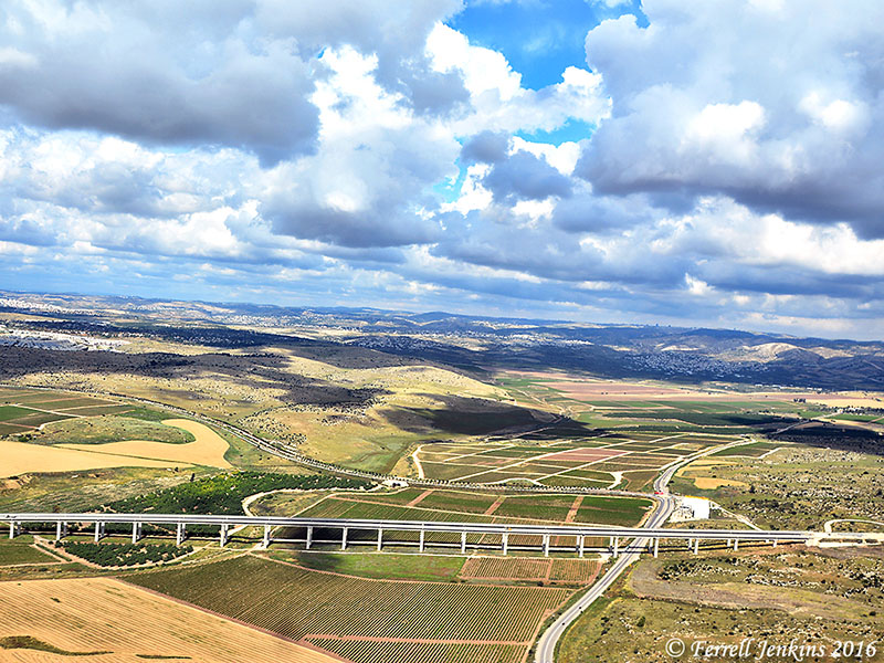
Aerial view of Aijalon (Ayalon) Valley. The view is to the north. The bridge is for the yet-to-open Tel Aviv-Jerusalem railway. Photo by Ferrell Jenkins
Three east-west valleys divide the Shephelah and provide access between the plain and the mountains. To the north is the valley of Aijalon. Further south is the valley of Sorek, and then the valley of Elah. Significant battles took place in the valley of Aijalon and the valley of Elah.
The town of Aijalon which overlooks the valley was allotted to the tribe of Dan (Joshua 19:42), but Dan moved to the northern part of the country and Aijalon was considered one of the cities of Judah and Benjamin (2 Chronicles 11:5-12). In the days of King Ahaz the city had fallen under Philistine control (2 Chronicles 28:16-20).
Have scientists discovered Joshua’s long day?
In 1969 an article began to be circulated in church bulletins, and later by Email, claiming that scientists had found evidence of the missing day of Joshua 10. Harry Rimmer had reported a similar story in The Harmony of Science and Scripture in 1936. There is no truth to this claim. I have an article written in response to it available at BibleWorld.com. An article by Dr. Bryant Wood is available at the ABR web site here.
This article is a revised reprint from 2009

You must be logged in to post a comment.